
Milwaukee Adopts New Ward Map For City
New districts coming next week. Riverwest further split between two council districts.
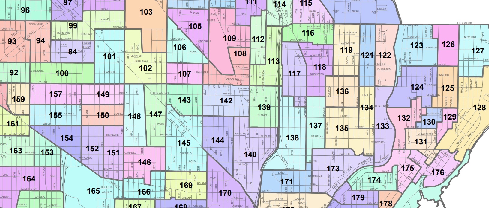
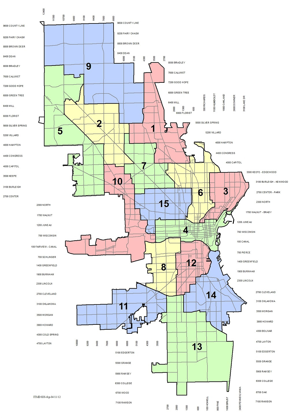
Milwaukee ward map. Image from the Legislative Reference Bureau.
City officials completed step one of the redistricting process Wednesday afternoon. The Milwaukee Common Council unanimously adopted ward maps for the entire city.
The wards, which under state law must hold between 1,000 and 4,000 residents, are the building blocks from which the city’s council districts are created.
The city has faced delay after delay in being able to start its work.“Pretty much every level of government, federal, state and county, has put us in a situation where we have two weeks to do wards and districts,” said Alderman Nik Kovac during a special meeting of the council held Wednesday.
The decennial census process was extended due to the pandemic, resulting in the data release being delayed. State officials could not agree on a revised redistricting timeline and then the Milwaukee County Board of Supervisors delayed its process after it created an Independent Redistricting Committee and repeatedly rejected its proposed maps.
The county process is critical for the city because city wards cannot cross county district boundaries.
“We really couldn’t start our work until we got their work,” said Ald. Ashanti Hamilton on Monday during a Judiciary & Legislation Committee meeting. The veteran alderman has served as the city’s lead elected official on the effort and repeatedly warned that other delays would impact the city process.
LRB had plenty of different variables to account for beyond just the Milwaukee County map in dividing 69 existing wards.
Milwaukee’s population dropped by 17,611 people, but in a very uneven manner. Losses primarily occurred throughout the North, Far North, Near West and Near South sides of the city. Population gains were seen Downtown, on the Lower East Side and in many of the outlying south-side neighborhoods.
The racial dynamics of the city also changed. As a percentage share, Milwaukee’s Black population fell by 1%, its white population declined 4.7%, its Hispanic population grew by 2.8% and its Asian population by 1.9%. The city is now 39.3% Black, 32.3% white, 20.1% Hispanic and 5.6% Asian.
The map the city adopted in 2012 had 324 wards. But when reevaluated using 2020 census data, 24 wards were below 1,000 residents and three were above the 4,000 resident maximum.
The revised map has 317 wards with an average size of 1,821 residents. And even wards that were unchanged by the process could result in confusion for voters the next time they vote in person: the wards were renumbered.
The fast-moving process resulted in a last-minute amendment before the full council. Three blocks in Riverwest, bounded by E. Keefe Ave., E. Townsend St., N. Humboldt Blvd. and N. Fratney St., were moved into a new ward.Hamilton called it a small change. “It’s something we discussed during the process, we just weren’t prepared to do it at the time,” said the alderman. “I do have to admit this is an unconventional process we are going through right now, so we had to some unconventional things.”
The change is being made to square what will likely be the dividing line between the Third (Kovac) and Sixth (Alderwoman Milele A. Coggs) aldermanic districts. The three blocks, and their 347 residents, will be placed in a ward with other residents located east of N. Fratney St.
Coggs said when she joined the council alongside Kovac in 2008 the boundary between their districts was primarily N. Holton St., which has long been viewed as a boundary between the predominately Black Harambee neighborhood and the predominantly white Riverwest neighborhood. “When we did redistricting 10 years ago the divider became primarily Pierce,” she said of the parallel street two blocks east.
Now it’s poised to move another block east into Riverwest.
“I’ve always told people it’s better when a neighborhood has two representatives,” said Kovac. “In theory, it allows for more responsiveness and more diversity of viewpoints.”
The council unanimously adopted the amendment and the full map, allowing it to meet a Nov. 18 deadline to return the ward maps to the county.
What’s Next?
A virtual town hall meeting will take place on Friday at 6 p.m. to present a draft district map (registration). Hosted by Hamilton with expected participation from other council members, the meeting will offer information in both English and Spanish.
A special meeting of the Judiciary & Legislation Committee is scheduled for Monday at 1:30 p.m. to review the map. The full council is slated to consider the district map on Nov. 23, the day it is due back to the county.
“Once again, this is attempting to do district maps in under a week,” said Hamilton. “However, these are the constraints we are under.”“It is our hope that we can at least have a meaningful process during this time frame,” said Hamilton.
Ald. Michael Murphy, at Monday’s committee meeting, expressed frustration at how the process is playing out in such a compressed time span. Murphy, the longest-serving council member, is going through his fourth redistricting process and said it would normally take months with ample public review.
“Alderman Murphy is right, this isn’t a crisis of our own making,” said Hamilton.
City Clerk Jim Owczarski told the committee that the city wasn’t able to do the wards and districts simultaneously because of public notice requirements.
Mayor Tom Barrett must still sign the legislation for both the ward and district maps for the city to officially meet its county obligations.
It will be years until the maps are used at the city level. All 15 council districts are up for election in 2024.
But the ward changes will also impact who people vote for in the 2022 Milwaukee County Board of Supervisors election, and where they do it. Polling places are determined by ward.
UPDATE: A third modification. Any special election for a council seat before 2024 would occur under new wards and old districts, with the election commission responsible for ensuring voters in the new wards would be eligible or ineligible to vote based on the 2012 map.
Maps and Statistics
- Adopted 2021 City Ward Map
- 2012 Ward Map
- 2012 Common Council Districts
- 2000 to 2010 Population Change by Aldermanic District
- 2010 to 2020 Population Change by Aldermanic District
- 2020 Population Change by Wards
- 2020 Aldermanic District Demographics
If you think stories like this are important, become a member of Urban Milwaukee and help support real, independent journalism. Plus you get some cool added benefits.
More about the Milwaukee County redistricting process
- Op Ed: Muslim Community Needs Representation - Janan Najeeb - Jan 29th, 2022
- City Hall: Council Ends Redistricting With Anger, Tears - Jeramey Jannene - Jan 18th, 2022
- Statement from Milwaukee Mayor Cavalier Johnson - Mayor Cavalier Johnson - Jan 18th, 2022
- City Hall: Latino Leaders Could Sue Over Redistricting - Jeramey Jannene - Jan 14th, 2022
- Latinx Leaders Condemn Common Council’s Refusal to Draw New Districts Reflecting Dramatic Growth of Latinx Population; Demand Second Legal Opinion - Voces de la Frontera - Jan 14th, 2022
- Voces de la Frontera Statement on Redistricting Decision - Voces de la Frontera - Jan 11th, 2022
- Statement on redistricting decision - JoCasta Zamarripa - Jan 10th, 2022
- City Hall: Milwaukee Starts Over On Redistricting, Only To Adopt Same Map Again - Jeramey Jannene - Jan 10th, 2022
- Statement by Milwaukee Mayor Tom Barrett: - Tom Barrett - Dec 14th, 2021
- City Hall: Council Halts Redistricting After Latino Pushback - Jeramey Jannene - Dec 14th, 2021
Read more about Milwaukee County redistricting process here
Political Contributions Tracker
Displaying political contributions between people mentioned in this story. Learn more.
City Hall
-
Menomonee Falls Could Get More Milwaukee Water
 Mar 11th, 2026 by Jeramey Jannene
-
Mayor Signs ‘Sanctuary City’ Resolution, With Key Caveat
 Mar 9th, 2026 by Jeramey Jannene
-
City Tows Hundreds With Unpaid Parking Citations
 Feb 25th, 2026 by Jeramey Jannene


Does anyone live in Wards 316 and 317 (the bits of Milwaukee in Washington and Waukesha Counties, respectively)?