
Study Released For 6.7-Mile 30th Street Trail
Plan envisions shared-use trail for bikers, pedestrians, perhaps commuter rail across the middle of city's North Side.
30th Street Corridor. Image from the City of Milwaukee.
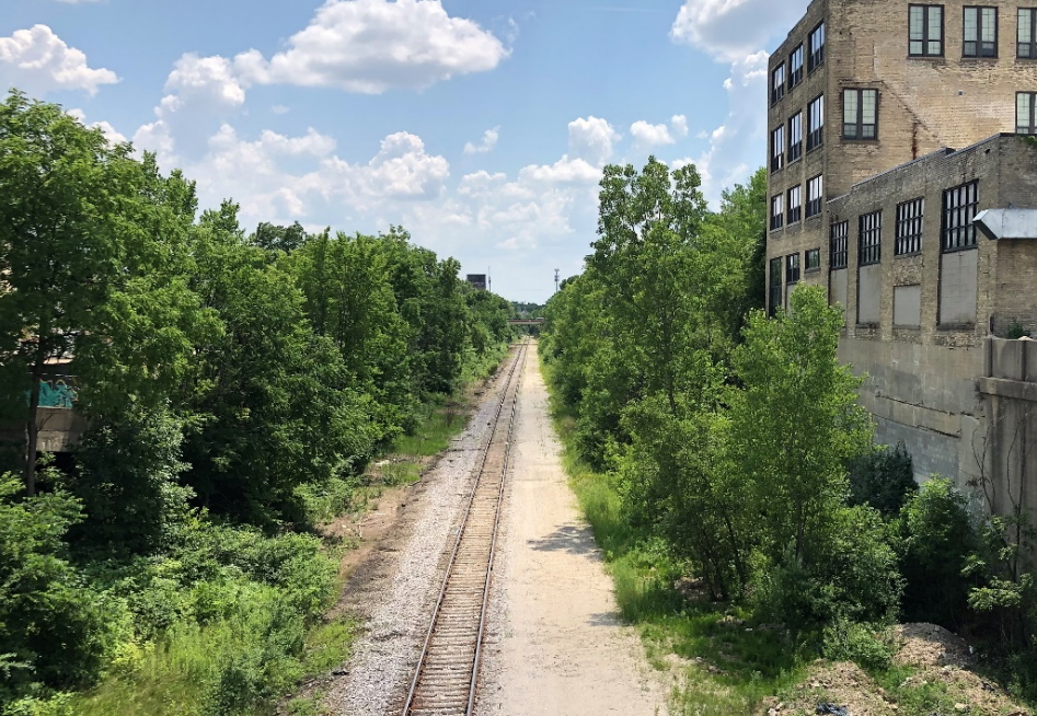
An underutilized rail corridor through the middle of Milwaukee could gain a paved, shared-use trail under a new plan from the City of Milwaukee, Milwaukee County, The Corridor Business Improvement District and Rails-to-Trails Conservancy.
Planners have identified the north-south, 6.7-mile corridor as a target for years, and a plan released Wednesday identifies issues and opportunities while providing a roadmap for next steps to create a trail for bikers, pedestrians and perhaps even commuter rail.
The corridor runs from approximately W. Silver Spring Dr. near N. Sherman Blvd. south to the Menomonee Valley and Hank Aaron State Trail. At its southern terminus, it would connect with the existing off-street trail network, while at multiple points along its northern leg it would connect with underserved neighborhoods and future planned trails.“We view this project as a catalytic component of our efforts to revitalize Milwaukee’s 30th Street Corridor,” said The Corridor executive director Cheryl Blue in a press release. “Though it will provide huge social and health benefits to the residents, we are determined that the economic impact benefits Black Milwaukee as well.”
A Rails-to-Trails study identifies the corridor as the most important potential trail investment in the region in terms of creating more equitable trail access. The 700-mile Route of the Badger initiative identifies the trail as a key link in a regional trail network.
Constructing the 30th Street Corridor trail and a planned extension of the Kinnickinnic River Trail would increase the number of Milwaukee residents with “safe” access to an off-street trail from 25,000 to 200,000 according to the report.
“This trail has the potential to strengthen neighborhoods in and around the 30th Street Corridor and provide more equitable access to outdoor recreational space, reducing health disparities and moving forward the city’s goals in racial equity,” said Mayor Tom Barrett in a statement. “This is a challenging project, but the city is committed to working with partners and the community to continue to ensure this project benefits residents and businesses.”
The rail line serves the Century City business park and a number of other industrial users. But the number of active users has fallen dramatically from its mid-century peak, most notably with the closure of Tower Automotive’s campus along W. Capitol Dr. Plans call for maintaining the active, single-track line while adding a paved, 10-foot-wide trail to the side.
The study identifies pinch points, properties with direct rail line access and spots where new bridges may be needed. It also provides cost estimates for different configuration options, including guidance on construction of a barrier between the rail line and trail (a chainlink fence is the cheapest option).Much of the corridor is at grade, with a series of bridges with excess space used to cross city streets. Near its southern end, approximately 1.2 miles of the corridor is below grade with city streets crossing above.
The rail line and surrounding land is owned by Canadian Pacific and leased to Wisconsin and Southern Railroad.
“The next step for a potential trail project is to craft and implement an equitable development strategy that will incorporate neighborhood leadership on the intersectional issues at play in the neighborhoods around the 30th Street rail corridor,” says the study.
Funds would need to be acquired for design, engineering and construction. The city and county routinely seek, and secure, such grants and the study lists a number of available programs.
The trail isn’t being planned in a vacuum. It’s one of 45 projects identified in the Connecting the Corridor Action Plan released in late 2020. That plan attempts to coordinate resources to maximize investments by sequencing projects and identifying funding opportunities.
A number of nearby trail projects are being actively advanced.
Last week we reported on a fundraising and planning effort to improve and extend the Beerline Trail in Riverwest and Harambee.
In late 2020 the city also secured a grant to develop a trail in the 20th Street corridor, a former streetcar corridor owned by We Energies. The Beerline and 20th Street trails would connect near W. Cornell St., with the Beerline running towards the 30th Street corridor.Further north, planning work is underway to study expanding the Lincoln Creek portion of the Oak Leaf Trail. It would run west from the creek’s intersection with W. Villard Ave. and the 20th Street corridor towards the 30th Street corridor. A grant was recently awarded for a portion of the project.
The study also explores how another prospective corridor use, a commuter rail line, could work with the freight rail line and trail. In many areas, the study authors conclude that all three uses could exist with dedicated lanes.
A full copy of the study can be found on Urban Milwaukee.
Maps


If you think stories like this are important, become a member of Urban Milwaukee and help support real, independent journalism. Plus you get some cool added benefits.
More about the 30th Street Corridor Trail
- Transportation: See Design Concepts for 30th Street Corridor Trail - Graham Kilmer - Apr 30th, 2026
- MKE County: County Holding Public Meeting on 30th Street Rail-Trail - Graham Kilmer - Feb 12th, 2026
- Transportation: 30th Street Corridor Trail Study Begins in May - Graham Kilmer - May 1st, 2025
- Milwaukee Wants To Buy 30th Street Line, Railroad Says No - Jeramey Jannene - Mar 18th, 2025
- Federal Grant Boosts Trail Connectivity Within Milwaukee’s 30th Street Corridor: A Model for Collaborative Community Development - Near West Side Partners, Inc. - Jan 13th, 2025
- Consultant Sought To Design 30th Street Corridor Trail - Jeramey Jannene - Jan 3rd, 2025
- Trail Extension Will Link Downtown With Planned 20th Street Trail - Jeramey Jannene - Dec 5th, 2024
- MKE County: Parks Finishes Trails Plan for Northwest Side - Graham Kilmer - Apr 5th, 2023
- Transportation: Should City Buy 30th Street Railroad Line? - Jeramey Jannene - Nov 10th, 2021
- Transportation: Study Released For 6.7-Mile 30th Street Trail - Jeramey Jannene - Jan 27th, 2021
Read more about 30th Street Corridor Trail here
Transportation
-
Milwaukee Plans 60 Traffic Safety Projects for 2026
 Apr 8th, 2026 by Jeramey Jannene
-
State To Reveal New I-794 Cost Estimates
 Apr 7th, 2026 by Jeramey Jannene
-
Bus Riders Can Finally Pay With Credit Card
 Apr 6th, 2026 by Graham Kilmer


“at grade, series of bridges” … should say “above grade”. The far northern end is ‘at grade’ around 35th and Cameron
Super cool to see this moving, even if only inching, forward. Stakeholders should all also remember we have local history on shared “rail with trail” corridor here in MKE — Oak Leaf Trail on east side coexisted with (barely) active C&NW line to North Avenue for a few years in late 1980s
@Steenwyr – Most of the corridor is actually at grade with the land around it. Many of the city streets go below grade to go under it and avoid a grade crossing. The setup, particularly at W. Capitol Dr. has created a situation where the streets can flood in heavy rain storms.
I think “shared” and “multi-use” are key concepts that planners and potential users have to be aware of. The trail experience in Milwaukee has deteriorated for both casual bikers and walkers with many cyclists on road bikes feeling entitled to travel at high rates of speed weaving in and out of pedestrians and other bikes without warning. I think enforced speed limits are in the future for these bike trails if this deliberate recklessness continues.
This will be a very big deal in moving toward equitable access to trails in Milwaukee. Kudos to all the volunteers and professionals who who have advocated for this for years!
I’ve learned about an upcoming book that’s sure to be of interest to trails advocates. Peter Harnik is a compelling storyteller and a leading expert about trails and parks.
Coming in May — “From Rails to Trails: The Making of America’s Active Transportation Network,” University of Nebraska Press.
Information at https://www.nebraskapress.unl.edu/nebraska/9781496222060/