
Parks Finishes Trails Plan for Northwest Side
Plan would dramatically increase access to trails for majority-Black neighborhoods.
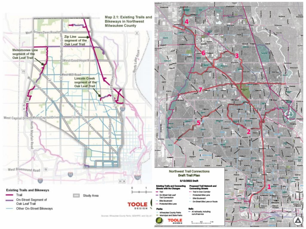
Existing Northwest side trails (left). Proposed Northwest side trails (right). Maps by Toole Design and Milwaukee County Parks.
For the past year and a half, Milwaukee County Parks has been engaged in a planning process to work out how and where it can increase access to bike and pedestrian trails on the Northwest Side.
Aptly called the Northwest Side Trail Connections Plan, the undertaking has yielded half a dozen ideas for new projects that will greatly increase trail access. Specifically, the goal of the project was to develop plans that would put a trail within 1.5 miles of everyone in the project area which is predominantly home to Black county residents. Only 30% of the county’s Black residents have direct access to a trail, according to a parks report from March.
The project area, according to parks, is bounded by “Bluemound Road on the south, County Line Road on the north, Green Bay Road on the east, and the Menomonee River on the west.” A map of the existing area shows it is currently a trail desert, with huge swaths of it unconnected to the county’s trail system. Existing trails essentially form a ring around the northwest-side neighborhoods in the city of Milwaukee that are home to most of Milwaukee’s Black residents.
The new plan identified seven priority trail corridors, all of which would also directly connect to the larger 135-mile Oak Leaf trail network. These new segments of the trail network would increase access to the wider trail network and the parks they run through for majority-Black neighborhoods on the city’s Northwest Side.
The project was able to capture public comment and input from more than 1000 people, including 600 from the project area, according to the parks department. Support for trails on the Northwest Side was unanimous, parks reported, with 100% of people surveyed supporting additional trails.
The plan also offers a vision of a “future trail and connecting street network” on the Northwest Side that includes a crisscrossing mixture of trail corridors, protected bike lanes, bike boulevards and on-street connections to the trail system. If all came to fruition, the percentage of Black residents on the Northwest side that are within 0.5 miles of a trail would jump from 6% to 64%.
The seven priority trail corridors that are the focus of the planning effort would create trail connections that run from the Menomonee Valley to the county line, and from the Menomonee River in the west to the Milwaukee River in the east. Three out of the seven projects would involve putting a trailway in an active or inactive railroad corridor.
The Northwest Side’s history as an industrial hub of the region means there are many railroad and waterway corridors that are publicly owned and can be converted to trails.
The next step for the plan is to adopt the trail plan as part of the county’s larger Park and Open Space Plan to improve the project’s eligibility for state and federal grants. These sorts of grants, like the Transportation Alternatives Program (TAP), have proven invaluable for maintaining and developing trails in the cash-strapped parks system.
Planned Trail Corridors
- 30th Street Corridor Trail: This trail would run from W. Hampton Ave. in the north to I-94 in the south. As Parks describes it, “North-south trail-with-rail through the heart of some of Milwaukee’s most disinvested neighborhoods with a proud industrial past ready for reinvention.”
- Lincoln Creek Trail Extension (south section): This trail would connect Meax Park to McGovern Park and Havenwoods State Forest. “Meandering trail that will connect neighborhoods to countywide Oak Leaf Trail system.”
- Lincoln Creek Trail Extension (north section): This connection would run between Havenwoods State Forest and Noyes Park and the Little Menomonee River Parkway. “Meandering trail that will connect central neighborhoods to parks and countywide Oak Leaf Trail system.”
- Little Menomonee Trail Extension: This trail would create a connection between the parkway and Lichter Park. “Scenic trail will close the last gap of the Oak Leaf Trail in the northern part of Milwaukee County.”
- Grantosa Drive: This trail would run from the Menomonee River Parkway to Lincoln Creek. “On-street connection that will connect the future Lincoln Creek Trail extensions to the Menomonee Parkway of Oak Leaf Trail.”
- Canadian Pacific Rail Trail: This segment would run from Havenwoods State Forest north to the Washington County Line. “Rail-trail that will continue the 30th Street Corridor Trail and provide connections to future trails in Havenwoods and Menomonee Parkway.”
- East-West Rail Trail” This trail would run from Kletsch Park in the east to the Little Menomonee River Parkway. “Rail-trail that will provide a critical and rare east-west connection between existing and future segments of the Oak Leaf Trail.”
If you think stories like this are important, become a member of Urban Milwaukee and help support real, independent journalism. Plus you get some cool added benefits.
More about the 30th Street Corridor Trail
- Transportation: See Design Concepts for 30th Street Corridor Trail - Graham Kilmer - Apr 30th, 2026
- MKE County: County Holding Public Meeting on 30th Street Rail-Trail - Graham Kilmer - Feb 12th, 2026
- Transportation: 30th Street Corridor Trail Study Begins in May - Graham Kilmer - May 1st, 2025
- Milwaukee Wants To Buy 30th Street Line, Railroad Says No - Jeramey Jannene - Mar 18th, 2025
- Federal Grant Boosts Trail Connectivity Within Milwaukee’s 30th Street Corridor: A Model for Collaborative Community Development - Near West Side Partners, Inc. - Jan 13th, 2025
- Consultant Sought To Design 30th Street Corridor Trail - Jeramey Jannene - Jan 3rd, 2025
- Trail Extension Will Link Downtown With Planned 20th Street Trail - Jeramey Jannene - Dec 5th, 2024
- MKE County: Parks Finishes Trails Plan for Northwest Side - Graham Kilmer - Apr 5th, 2023
- Transportation: Should City Buy 30th Street Railroad Line? - Jeramey Jannene - Nov 10th, 2021
- Transportation: Study Released For 6.7-Mile 30th Street Trail - Jeramey Jannene - Jan 27th, 2021
Read more about 30th Street Corridor Trail here
MKE County
-
Incumbents Sweep County Board Elections
 Apr 7th, 2026 by Graham Kilmer
-
Federal Judge Won’t Vacate Dugan Conviction
 Apr 6th, 2026 by Graham Kilmer
-
Sup. Vincent Faces Challenge in Heated Race for District 11
 Apr 6th, 2026 by Graham Kilmer
Transportation
-
Milwaukee Plans 60 Traffic Safety Projects for 2026
 Apr 8th, 2026 by Jeramey Jannene
-
State To Reveal New I-794 Cost Estimates
 Apr 7th, 2026 by Jeramey Jannene
-
Bus Riders Can Finally Pay With Credit Card
 Apr 6th, 2026 by Graham Kilmer


This is encouraging news.
It’s an important step in moving toward equitable access for all Milwaukeeans to recreational trails. It can also help support commuter biking across the city.
Kudos to all the citizens who have been advocating for this–some of them have been working on this for decades. And kudos to Milwaukee County Parks planners.