City Seeks Grants to Build Bike Lanes on 2nd, Center, Sherman and Lisbon
Part of mayor's proposal to build 50 miles of protected bike lanes by 2026.
A network of protected bike lanes could soon connect across a substantial portion of Milwaukee.
The Department of Public Works (DPW) is vying for state-administered federal funding to build 4.25 miles of protected lanes, expand the Bublr fleet of electric bikes and develop a citywide strategy for implementing a protected bikeway network. Each of the three new protected lanes proposed would connect with an already-funded protected bike lane project, expanding the utility of both the new and existing efforts.
The protected lanes would include physical barriers to protect cyclists, creating safe routes for those of all ages and abilities.
The latest proposals, which would join several projects already underway, follow Mayor Cavalier Johnson‘s June pledge to have 50 miles of protected lanes constructed or under development by 2026. It also fits within the mayor’s first act as mayor, proclaiming reckless driving a public health crisis, by promoting traffic calming with reduced roadway widths.
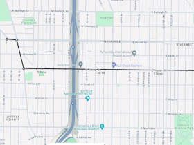
A 1.9-mile protected lane would stretch from the irregular intersection of W. Locust Street, N. Teutonia Avenue. and W. Hopkins Street south to W. Center Street and then east to N. Humboldt Boulevard. The east-west route would connect the North Division, Harambee and Riverwest neighborhoods and feed into the Beerline Trail on the eastern end. The northwest edge would feed into a planned and funded 2.2-mile protected lane on W. Hopkins Street. The new project would cost $2.07 million.
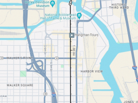
A second 1.9-mile protected lane would connect Downtown, Walker’s Point, Clock Tower Acres and the Harbor District via S. 2nd Street. It would also link up with an upcoming upgrade to the Kinnickinnic River Trail, for which final designs were released earlier this year. Starting at S. 1st Street and W. Maple Street, the protected lane would run west for a block before heading north on S. 2nd Street to the Milwaukee River. It would continue across the river, where the street becomes N. Plankinton Avenue before ending at W. Michigan St. in Westown. The protected lane would be a cycling upgrade to a street that was already substantially overhauled in 2010. The project would cost $2.04 million.
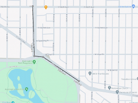
A 0.45-mile protected lane would run south from the intersection of W. North Avenue and N. Sherman Boulevard to W. Lisbon Avenue and then east on W. Lloyd Street to N. 40th Street. Serving the Sherman Park and Washington Park neighborhoods, it would connect with the planned reconstruction of N. Sherman Boulevard to the north and Washington Park to the south. The southeast edge of the protected lane would connect with a planned and funded protected lane that would run east to N. 20th Street. The project would cost $2.09 million.
An additional project would add 300 electric-assist bikes and 165 docks to the Bublr Bikes fleet at a cost of $2.06 million. A nonprofit operates the bike-sharing system, but the city and neighboring municipalities own much of the fleet. In 2022, approximately 350 e-bikes were added to the system.
DPW is also seeking a grant to develop a strategy plan to “educate, build awareness and help implement protected bikeways.” The project cost is $440,000.
Through the federally-funded Transportation Alternatives Program, the Wisconsin Department of Transportation could fund all or some the grant applications. Communities across the state apply for the competitive awards. The Southeastern Wisconsin Regional Planning Commission will review the applications from the Milwaukee area.
The program covers 80% of any project costs, with the grantee covering the remaining 20%. Awards, according to a program information sheet, are expected to be announced in April.
The Common Council unanimously endorsed the applications on Dec. 13.
Bike Lane Growth
The applications come as the city is already expanding the number and types of protected bike lanes that are being installed.
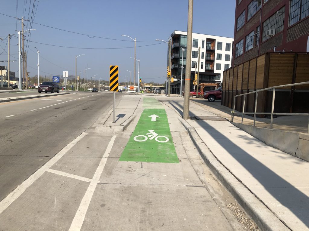
Completely separated lanes are being finished on W. Walnut Street as part of a complete reconstruction project. Earlier this year, lanes separated by parked vehicles or plastic delineators were installed on W. Lapham Street, W. Highland Avenue and E. North Avenue.
The new lanes join a handful of short protected lane segments already installed, including on Kilbourn Avenue through Downtown, on the Locust Street and North Avenue Milwaukee River bridges and on the N. Hawley Road bridge over the Menomonee River.
Powerline Trail Expansion
Several off-street trails are also being expanded, none faster than the Powerline Trail.
The new trail, which is planned to run east-west across almost all of southern Milwaukee County, saw its first phase open in 2022 between the intersection of S. 99th Street and W. Cold Spring Road and the intersection of S. 60th Street and W. Plainfield Avenue. It is now poised to enter the City of Milwaukee, with an extension to Pondview Park and S. 30th Street and a northern leg into Zablocki Park that terminates at W. Howard Avenue.
The City of Milwaukee approved a cost-sharing agreement with the City of Greenfield in September that will have Milwaukee pay for 27% (approximately $40,000) of the local design and construction costs on the $1.1 million, state-backed project.
Construction is expected to take place in 2024.
The We Energies-owned corridor is a former interurban corridor that was used primarily to shuttle coal to a power plant in St. Francis.
The city secured a $200,000 award earlier in 2023 to study extending the trail east to Lake Michigan near the former power plant.
A second “Powerline Trail” is being developed in the N. 20th Street corridor on the far north side of Milwaukee in a former interurban corridor. Work is also underway to add a trail to the 30th Street railroad corridor and construction is underway on a Beerline Trail extension under Interstate 43.
If you think stories like this are important, become a member of Urban Milwaukee and help support real, independent journalism. Plus you get some cool added benefits.
Transportation
-
Congestion Pricing Cuts Air Pollution in New York City
 Dec 14th, 2025 by Jeff Wood
-
FTA Tells Milwaukee to Crack Down on Fare Evasion — Even Where Fares Don’t Exist
 Dec 12th, 2025 by Graham Kilmer
-
Will GOGO’s Bus Service Ever Get Going?
 Dec 9th, 2025 by Jeramey Jannene









I like this
This is great. I just hope they really plan these things together so we don’t end up with wastelands and poor connections between each of these projects. All the improvements on Walnut are great, but 3rd to 4th is a bit iffy in both directions and still two race lanes plus slip lane eastbound. I think 9th through 13th also leaves a bit to be desired, understanding they probably couldn’t touch WisDOTs bridge, but sure could’ve done with less pavement around 12th and FDL. Every inch available for reckless driving will be abused, so I don’t know why they leave that opportunity.