Milwaukee Planning Three Protected Bike Lanes, Trail to Lake
City seeking federal funds from state to advance projects across city.
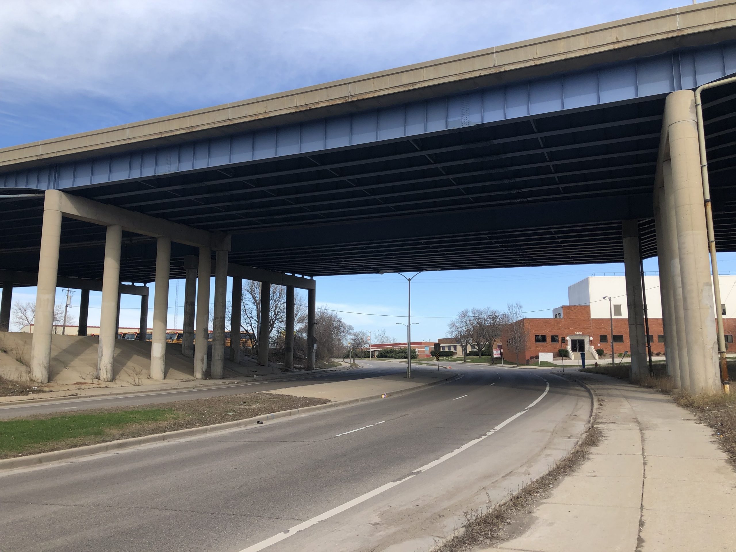
W. Oklahoma Ave. under Interstate 43/94. Photo by Jeramey Jannene.
The number of Milwaukee neighborhoods with protected bicycle lanes would increase substantially if the city is successful in securing four new grant requests.
The Department of Public Works (DPW) is vying for $5 million in state-administered federal funding to develop three new protected lines spanning several miles and extend the Powerline Trail in two directions.
The grants would cover 80% of the costs to design and build protected bicycle lanes on W. Walnut Street in the Midtown and Walnut Hill neighborhoods, W. Hopkins Street in the North Division and Franklin Heights neighborhoods near the Century City business park and Oklahoma Ave. in the Bay View, Polonia and Morgandale neighborhoods.
The fourth grant would cover 80% of the study costs of extending the Powerline Trail, which currently runs primarily through the City of Greenfield, north to the Hank Aaron State Trail near the Zoo Interchange from the Hale Interchange and east to Lake Michigan from S. 35th St.
The Wisconsin Department of Transportation oversees the funding through its Transportation Alternatives Program (TAP) and awards grants on a competitive basis.
W. Walnut Street and W. Lisbon Avenue Protected Bike Lane
DPW is planning to build 1.33 miles of protected bike lanes between N. 20th Street and N. 40th Street on W. Walnut Street and W. Lisbon Avenue.
The corridor is effectively one street that angles west of N. 24th Street. The protected bike lane would connect Washington Park on the west with an under-construction, fully-separated protected bike lane east of N. 20th St. The city is rebuilding W. Walnut St. from Interstate 43 to N. 20th St., converting the street from a four-lane road to a two-lane street with separated bike lanes.
“This section of W. Walnut Street and W. Lisbon Avenue had over 500 crashes from 2017-2021, including 17 bicycle and pedestrian crashes,” says the city’s grant application.
East of N. 30th Street, the current configuration is a four-lane, divided roadway. To the west it is a two-lane street. Each segment includes a painted bicycle lane.
The grant application is for a $1.62 million project, with $1.3 million from the state and $324,348 from the city.
W. Hopkins Street Protected Bike Lane
The 2.2-mile W. Hopkins Street project would run northwest from N. Teutonia Avenue and W. Locust Street. to W. Capitol Drive and N. 34th Street.
The stretch west of N. 27th Street forms the eastern edge of the Century City business park, with most of the adjoining land mostly vacant.
Most of the corridor has two lanes today, with the part near Century City having a painted bike lane and no cross traffic.
It’s been identified as a high crash area.
“W. Hopkins Street, W. Capitol Dr. and W. Locust St. are on
the High-Injury Network (high concentration of severe/fatal injuries),” says the city’s grant application.
Small portions of the protected bike lane would be constructed on W. Locust Street (just west of N. Teutonia Ave.) and W. Capitol Dr. (under the 30th Street railroad corridor).
The grant application is for a $1.95 million project, with $1.56 million coming from the state and $390,325 from the city.
Oklahoma Avenue Protected Bike Lane
The 1-mile Oklahoma Avenue project would run from S. Howell Avenue west to S. 6th Street.
It would add a protected bicycle lane on what is primarily a four-lane street that connects Humboldt Park in Bay View with the Polonia and Morgandale neighborhoods west of Interstate 43/94.
The character of the street changes dramatically across the one-mile stretch. It is a heavily-trafficked street three-lane street lined by homes between S. Howell Avenue and S. Chase Avenue, then angles southwest as a four-lane, divided roadway between a shopping center and industrial complex. It curves back northwest as it goes underneath the freeway, with industrial tenants on both sides.
“W Oklahoma and S 6th St are on the High-Injury Network
(high concentration of severe/fatal injuries) with over 200 crashes over the past five years,” says the grant application.
To the east of S. Howell Avenue, DPW recently installed a series of pinned-on concrete bump-outs to reduce illegal passing and shorten pedestrian crossing distances. An earlier, painted-based road diet narrowed the segment from four lanes to two.
To the west of S. 6th Street, DPW is currently working on a bicycle-focused traffic calming project that runs to S. 27th Street. A public meeting on the project is scheduled for June 13. A 2020 TAP grant is funding that project.
The latest grant application includes a one-block addition, north on S. 6th Street to W. Manitoba Street. and toward the western segment of the Kinnickinnic River Trail.
The grant application is for a $1.11 million project, with $885,580 coming from the state and $221,395 from the city.
Powerline Trail Extensions
DPW is also vying for a smaller grant to study how to extend the Powerline Trail north and east.
The first phase of the trail was already built in a We Energies-owned corridor from the Oak Leaf Trail at S. 105th St. and W. Cold Spring Rd. east to S. 60th St. The corridor roughly parallels W. Plainfield Ave.
The second phase, for which funding for planning work was secured, would run from S. 60th St. to Pondview Park, just east of S. 33rd St. in the City of Greenfield. DPW would study extending that trail east the entire way to Lake Michigan.
It would also explore extending the trail north to the Hank Aaron State Trail near the Zoo Interchange. Much of that would extension run through land in the City of West Allis.
Both corridors are largely open space, up to 200 feet wide, that were originally developed for an interurban rail line but now house high-voltage power lines. The proposed paved trail is to be 10 feet wide, accommodating cyclists, walkers, runners and more.
Milwaukee applied unsuccessfully for a TAP grant for the project last year
The grant application is $250,000, with $200,000 coming from the state. The city would need to provide a $50,000 local match.
A study, completed by the Wisconsin Bike Fed for the City of Milwaukee approximately a decade ago, identifies potential route issues and options for the Powerline Trail (on page 11) and other corridors.
The trail is the first new section of the Route of the Badger, a 700-mile regional trail network, to be constructed. The proposal calls for augmenting existing trails, like the Oak Leaf Trail, by adding new sections and connections. Proposals include a 30th Street Corridor Trail, a northside powerline trail paralleling N. 20th St., a western extension of the Kinnickinnic River Trail and a number of new suburban trails.
The Public Works Committee unanimously endorsed the latest grant applications Wednesday. The full council is to vote on the requests June 20.
If you think stories like this are important, become a member of Urban Milwaukee and help support real, independent journalism. Plus you get some cool added benefits.
Transportation
-
Milwaukee Plans 60 Traffic Safety Projects for 2026
 Apr 8th, 2026 by Jeramey Jannene
-
State To Reveal New I-794 Cost Estimates
 Apr 7th, 2026 by Jeramey Jannene
-
Bus Riders Can Finally Pay With Credit Card
 Apr 6th, 2026 by Graham Kilmer