
Independent Committee Submits Final Map for Supervisor Districts
But independence of the Independent Redistricting Committee is now in question, as county board could face lawsuits.
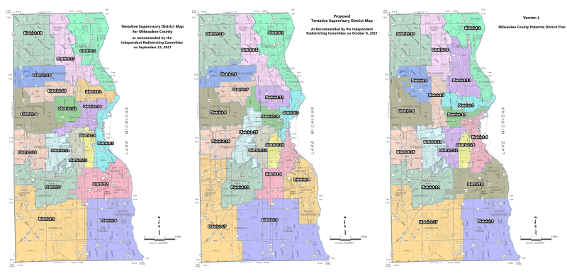
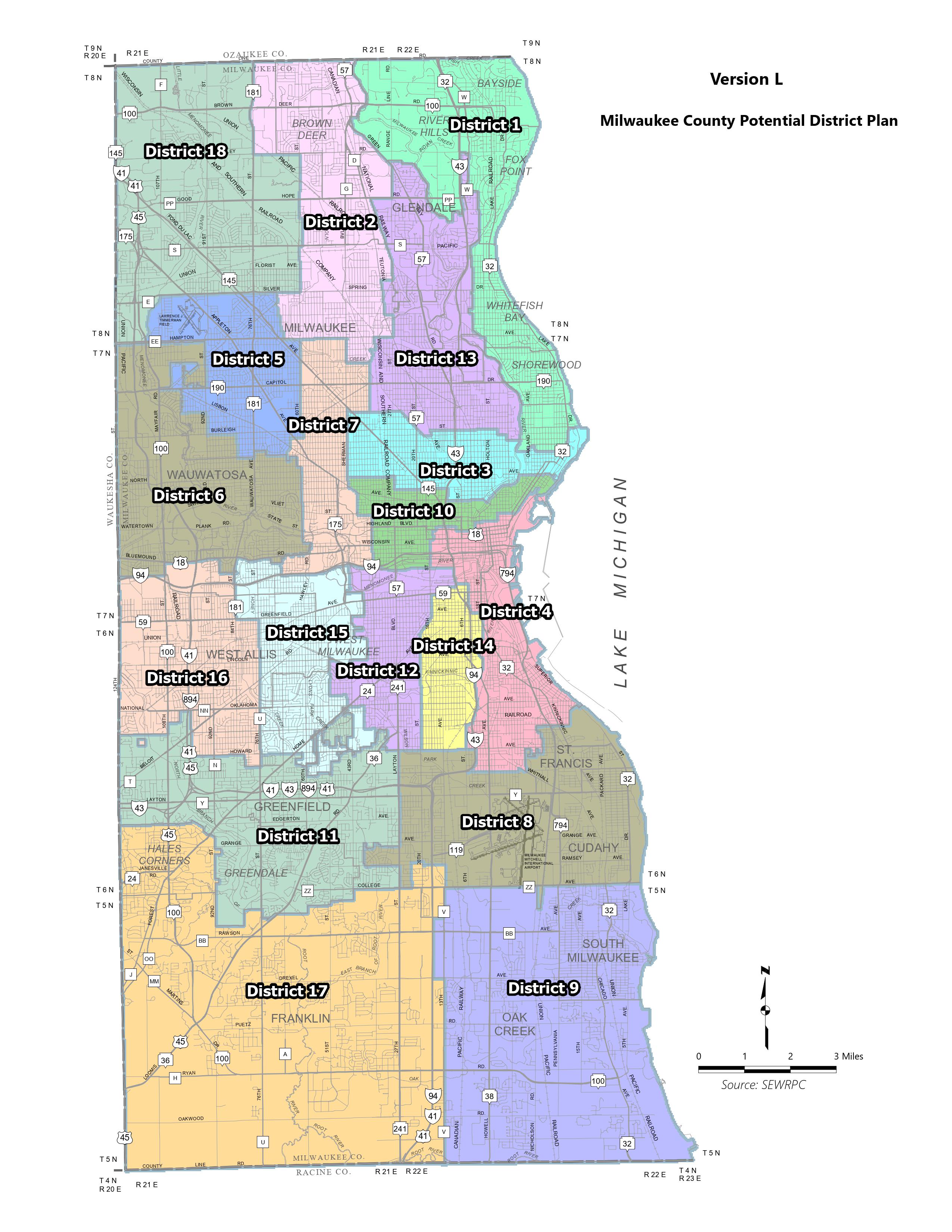
Independent Redistricting Committee’s first, second and third maps.
The Milwaukee County Board, more than a month behind schedule on its redistricting process, will consider the final map recommended to it by its own Independent Redistricting Committee (IRC). But the extent to which the process remains independent is now in question.
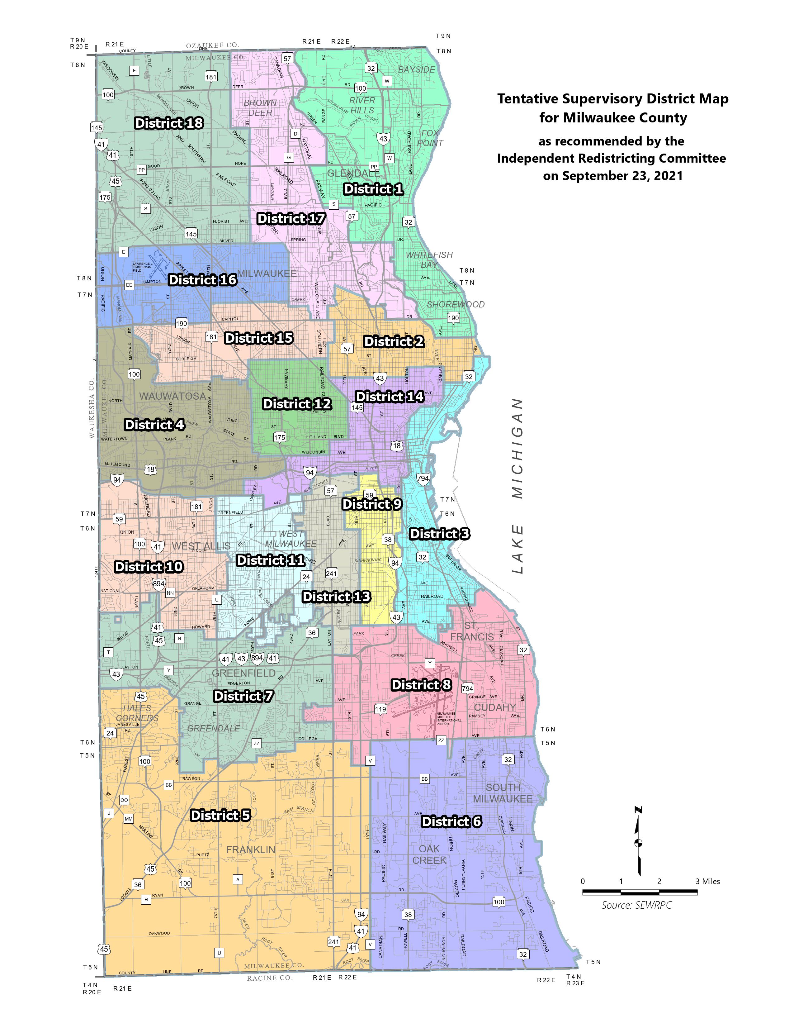
This is the final product from the independent committee of retired judges. The board rejected the IRC’s first map, suggesting that incumbency should be considered, and expressed concerns about white voter dilution of at least one majority Black district. Then it rejected a second map, suggesting even more changes.
The process moves closer to the mid-November deadline for the certification of maps needed for the Spring 2022 election. And while the county delays, it is also delaying the 18 underlying municipalities, including the City of Milwaukee, that need the county map to move forward with drawing election wards.
If the board misses the November deadline, it is very likely to face legal action. Milwaukee County Corporation Counsel Margaret Daun has provided legal opinions stating it would put the county at “acute risk for litigation.” In her latest opinion, Daun advised that claims could be made for a number of reasons including violations of the “Voting Rights Act of 1965 (VRA), denial of due process, First Amendment claims… such as a mandamus action to force the drawing of maps, or a request that a court intervene to draw the maps itself.”
The board created the IRC in 2016. Then, and in the months leading up to redistricting process, supervisors explained that the IRC was intended to eliminate partisan and political interference from the drawing of legislative districts. The committee is composed of retired judges Charles Clevert, Jean DiMotto, James A. Gramling, Jr., Chuck Kahn, Fred Kessler and Mary Kuhnmuench.
But when the IRC submitted its first map, the clearest objection from supervisors was that it had not considered their incumbency. Sup. Steven Shea said, at a meeting of the County Board’s Judiciary and General Services Committee: “It’s not fair, to the members of this body, to commit political hari-kari by signing their own political death warrant, by asking them to vote themselves out of office.”
After that meeting, the IRC directed the Southeastern Wisconsin Regional Planning Commission (SEWRPC) to consider the addresses of current supervisors in future iterations of supervisory districts.
The board has the authority to vote to suspend the IRC process at any time and draw maps that please enough supervisors to secure approval. Instead, supervisors continue to reject maps and direct the IRC with such specific instructions that the independent committee has been forced to abandon its own redistricting principles, including some specifically outlined in the county board’s authorization ordinance, like compactly drawn districts.
IRC Makes Final Recommendation
The board has already rejected two maps recommended by the IRC. It will consider the third and final map this week. Under the county’s redistricting ordinance, if the third map is rejected, the board can begin to make amendments to the map itself.
Based upon data from the 2020 Census, Milwaukee County is now a majority-minority county, with approximately 52% of its population being Black, Hispanic, Asian or mixed-race; and 46% of the county’s voting-age population is part of a minority racial or ethnic group.
The IRC sought to draw maps that had equal numbers of white districts and majority-minority districts. It landed on two Hispanic majority districts, six majority Black districts and one majority-minority district where no single race or ethnicity held a majority.
Since the first map was submitted to the board, supervisors, members of the public and other elected officials have expressed concerns and made suggestions for the maps that range from small, specific changes, to broad suggestions for redistricting principles. Concern about population levels and district lines in majority Black supervisory districts is something that came up with every map.
The first map, which was drawn according to the principles of the IRC, drew concerns from some supervisors about white voter dilution of a majority Black district that was drawn to include a very wealthy and white section of the Upper East Side. There were also concerns about whether the majority Black districts had solid enough majorities, and that historic voting patterns made some majority Black districts weaker than they appeared.
These concerns continued with each successive map. Each time, as changes were made, a new area of the redrawn map would produce concerns over majority Black districts, packing of Black districts to reach a significant majority, cracking of districts to achieve six majority Black districts. Or, as with one iteration, the majority-minority district was drawn to include portions of the county that are majority white and have a history of high voter turnout, potentially diluting the minority vote.
The IRC took seriously the concerns of Black vote dilution, and deliberated at length the comments from the public and elected officials regarding specific boundaries for majority Black districts. But once the addresses of sitting supervisors became a factor, the IRC and SEWRPC failed to develop maps that matched the majorities found in the first map that ignored incumbency.
That first IRC map remains the map with the strongest majority Black districts based on voting age population. It had four districts where the voting age population was more than 60% Black, and two districts that were above 50%. No other map has achieved that, but the first map was also the last map drawn before the incumbency of sitting supervisors was considered by the IRC and technical staff at SEWRPC.
Sup. Sylvia Ortiz-Velez, one of the first supervisors to express concerns about white voter dilution in majority Black districts, noticed this trend. On Oct. 12, she said to her colleagues on the judiciary committee, “I believe that starting with a clean slate gave the minority communities the best opportunity to create the… best maps to honor the voting rights act.”
Incumbency or Independence
Before drawing any maps, the six retired judges approved four redistricting principles that would guide their process and resulting maps.
Those principles were honoring the intent of the Voting Rights Act, respect for the boundaries of municipalities, districts with equally apportioned population and compact districts. Early on, the IRC voted unanimously to not consider incumbency as a redistricting principle. And nowhere in the county board’s own ordinance does it say incumbency should be considered.
Nevertheless, on Sept. 29, members of the board’s Judiciary and General Services Committee rebuked the IRC for not considering the addresses of elected supervisors, and, among other things, Sup. Sheldon Wasserman suggested the IRC consider a map that was previously drawn by IRC member Judge Kessler without the input of the committee and before the IRC’s principles were established.
Two days later, on Oct. 1, at a meeting of the full county board, the first objections from supervisors to considering incumbency were recorded. Since the first map rejection, public comment on the question of incumbency has nearly universally asked that it not be considered.
Of the 18 member board, six supervisors have explicitly objected, or questioned, the consideration of incumbency in redistricting. They were Supervisors Shawn Rolland, Sequanna Taylor, Ryan Clancy, Felesia Martin and Ortiz-Velez. Once the addresses of supervisors became a consideration, Sup. John Weishan, Jr. said he thought some areas showed an “over reliance” on incumbency. But Weishan was also among the supervisors that suggested the IRC consider incumbency after the first map was submitted. Sup. Patti Logsdon also asked SEWRPC how incumbency was affecting district boundaries, and said supervisors should not be requesting specific boundary changes out of self-interest.
In a tweet after this story was published, Chairwoman Marcelia Nicholson noted that she did not provide her address for consideration. On Oct. 1, SEWRPC did show a map overlaying supervisor addresses onto the districts, but staff were still working to confirm the addresses of all 18 supervisors.
The IRC had already voted in August not to allow the circulation of Kessler’s map to members or SEWRPC staff, so as not to taint the independence of the process. Daun, whose office was directed to provide legal counsel to the IRC, previously warned the judges against considering Kessler’s map. “This is a bit like a bell that cannot be unrung,” she said. “Once you’ve seen them, you’ve seen them.”
But they ended up ringing the bell and looking at the map on Oct. 1.
Before a discussion of his map, Kessler disclosed all his connections to elected supervisors. He said he was at a fundraiser for Rep. Jonathan Brostoff and Sup. Eddie Cullen’s father — Milwaukee County Treasurer David Cullen — discussed his son moving to a specific area of the county. He said he knew Sup. Joe Czarnezki, adding that Czarnezki endorsed him for judge (Czarnezki has announced he will not seek re-election). He said Wasserman worked on his congressional campaign, and that he mentored him during his time in the assembly: “He was a very close friend.” He also noted that he served with both Cullen’s father and Sup. Tony Staskunas in the assembly.
At this meeting, Judge Kuhnmuench pushed back against the IRC considering incumbency based upon the suggestion of the supervisors. “They have the right to change, and take that issue on, and do it in a transparent way, not use us to, and I’m using that word intentionally, to use us to legitimize that which we don’t believe is legitimate,” she said.
During this meeting, Judge Gramling put it bluntly, saying “Incumbency was forced upon us as an issue by the committee.” At the next meeting of the IRC, Kevin Muhs, executive director of SEWRPC, said that the new maps did consider the addresses of existing supervisors.
Each successive map has used as a starting point maps that were drawn after the consideration of incumbency.
Now the IRC has recommended their final map to the board. The board can approve it with a simple majority, or set about drawing its own districts and forget an independent process.
Supervisors have held up the independent redistricting process as a possible model for other legislative bodies going all the way back to when it was just a proposal under consideration. In 2015 as the board was considering making its process independent, then board Chairman Theodore Lipscomb, Sr. said, “I am open to Milwaukee County exploring options at the local level that could serve as an example statewide to ensure representation for all.”
Former Sup. Steve Taylor, who co-sponsored the independent redistricting ordinance with current Sup. Weishan, said at the time that they chose to pursue redistricting reforms then because it would be more than five years and two elections before the next round of map drawing. He thought the likelihood of board turnover in that time reduced the urge to protect the status quo, saying, “There’s no self interest to protect.”
The latest legal opinion issued by Daun on redistricting questions said her office has not found any relevant case law or provisions in the 1965 Voting Rights Act supporting the proposition that incumbency “should or must be considered.” Daun goes on to explain that considering incumbency will not help the county if the maps face a legal challenge, adding that, it could in fact have the opposite effect.
“More broadly,” Daun wrote, “preferencing incumbency may establish a precedent to do so during statewide redistricting, which could be argued as a reason to minimally alter the maps created in 2011 by a Republican-controlled Wisconsin State Legislature and signed off on by a Republican governor, resulting in what many have argued to be one of the most constitutionally suspect partisan gerrymanders ever accomplished in U.S. history.”
Update: This story was updated to reflect that Chairwoman Nicholson did not provide her home address to SEWRPC; and to reflect that Sup. Felesia Martin also spoke against protecting incumbency; and to reflect that Sup. Logsdon questioned how incumbency was affecting district boundaries.
If you think stories like this are important, become a member of Urban Milwaukee and help support real, independent journalism. Plus you get some cool added benefits.
More about the Milwaukee County redistricting process
- Op Ed: Muslim Community Needs Representation - Janan Najeeb - Jan 29th, 2022
- City Hall: Council Ends Redistricting With Anger, Tears - Jeramey Jannene - Jan 18th, 2022
- Statement from Milwaukee Mayor Cavalier Johnson - Mayor Cavalier Johnson - Jan 18th, 2022
- City Hall: Latino Leaders Could Sue Over Redistricting - Jeramey Jannene - Jan 14th, 2022
- Latinx Leaders Condemn Common Council’s Refusal to Draw New Districts Reflecting Dramatic Growth of Latinx Population; Demand Second Legal Opinion - Voces de la Frontera - Jan 14th, 2022
- Voces de la Frontera Statement on Redistricting Decision - Voces de la Frontera - Jan 11th, 2022
- Statement on redistricting decision - JoCasta Zamarripa - Jan 10th, 2022
- City Hall: Milwaukee Starts Over On Redistricting, Only To Adopt Same Map Again - Jeramey Jannene - Jan 10th, 2022
- Statement by Milwaukee Mayor Tom Barrett: - Tom Barrett - Dec 14th, 2021
- City Hall: Council Halts Redistricting After Latino Pushback - Jeramey Jannene - Dec 14th, 2021
Read more about Milwaukee County redistricting process here
MKE County
-
Incumbents Sweep County Board Elections
 Apr 7th, 2026 by Graham Kilmer
-
Federal Judge Won’t Vacate Dugan Conviction
 Apr 6th, 2026 by Graham Kilmer
-
Sup. Vincent Faces Challenge in Heated Race for District 11
 Apr 6th, 2026 by Graham Kilmer


If I’m reading this correctly, it appears that some Board members were in favor of an independent maps committee until it affected THEIR districts. (And chances for re-election). That’s shameful. Especially galling is the on-record position of so-called progressives (yes, You Steve). The precedents set by this tampering will surely be used by state Republicans in the statewide redistributing battle to solidify their grip on the State legislature- and Shea and friends will be complicit. Again, SHAME!
Thank you for the thorough reporting on what is an extremely important issue! The Board creating an independent committee was a great step forward for good government in Milwaukee, but that idea is now running up against the reality of self-interest amongst the electeds. While there is something to be said about protecting institutional knowledge on the county board by considering incumbency in map design, the principles of the Voting Rights Act and the ten year duration of the maps really do overwhelm that. Part of the issue is that the previous maps were not at all drawn with compactness in mind (some of the districts literally look like salamanders, which is where “gerrymandering” as a phrase came from), so any map that aims for compactness is going to feature pretty radical changes just from that. The stakes are high, especially as this could impact redistricting at other levels of government.
Just the fact that there’s an independent body under ordinance creating maps that don’t take incumbency into consideration is a rather significant show of progress from ten years ago. Then, the NAACP (aided by UWM) designed a map based on compactness and protecting minority representation that did not consider incumbency. Because it ignored incumbency, it wasn’t taken seriously.