Milwaukee Leads Great Lakes Cities
Its waterfront redevelopment is many decades ahead of Chicago, Detroit, Cleveland and Buffalo. Part IV of a series.
Local residents may assume that the magnitude and quality of waterfront development occurring in Milwaukee is not unique and simply part of a national trend. In truth, this development is exceptional in its scope and the degree to which it has included high-quality public amenities. Perhaps the most useful comparison is with Chicago, which also has a Lake Michigan shoreline and downtown rivers that historically formed an estuary and which has recently experienced the greatest influx of downtown residential development of any American city. Other useful comparisons are to the waterfront areas of the three other major U.S. cities on the Great Lakes — Buffalo, Cleveland, and Detroit — which share some of the physiographic features of Milwaukee’s waterfront, as well as the industrial legacy and more recent “Rust Belt” decline. Milwaukee outshines all four cities in its water-related redevelopment.
How Chicago Compares
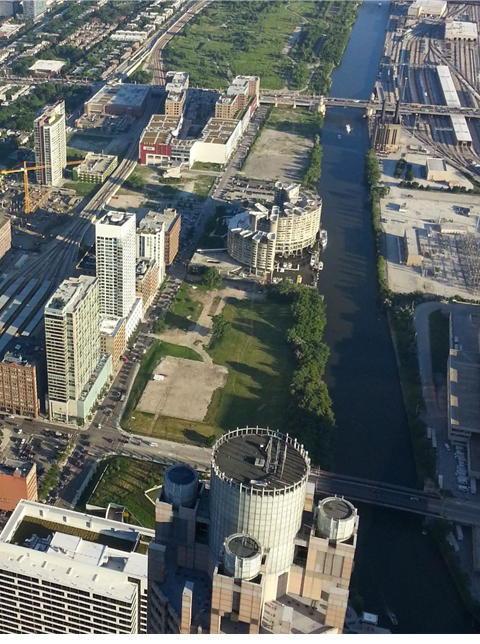
With the exception of a single building, the land bordering the South Branch of the Chicago River remains a vacant industrial wasteland. (2013)
Chicago would seem to be the city with the best potential to create a freshwater landscape equal in quality to Milwaukee, given the extraordinary amount of redevelopment that has occurred in Chicago’s Downtown over the past 20 years. From 2000 to 2010, downtown Chicago saw an increase in population that exceeded that of any city in the US (as reported in one census study). The downtown area was the focus of a high-rise residential construction boom exceeded only by New York City. With this investment, and the near universal appeal of waterfront locations, one would expect the greatest transformation would have occurred along the Chicago’s rivers, as has been the case in Milwaukee.
And yet, even with these extraordinary factors seemingly favoring water- front redevelopment, the city has continued to largely turn its back on the portion of its freshwater landscape formed by its downtown rivers (the North Branch, South Branch, and Main Stem of the Chicago River). Whereas the fundamental character of Milwaukee’s urban rivers has changed over the past four decades from being essentially industrial sewers and shipping channels to a restored urban fishery and recreational and residential amenity, the fundamental character of Chicago’s downtown rivers is still largely locked in that city’s industrial past, with continued prioritized use as a conveyance system for shipment of bulk cargo by barges and for discharge of partially treated wastewater to the Mississippi River system.
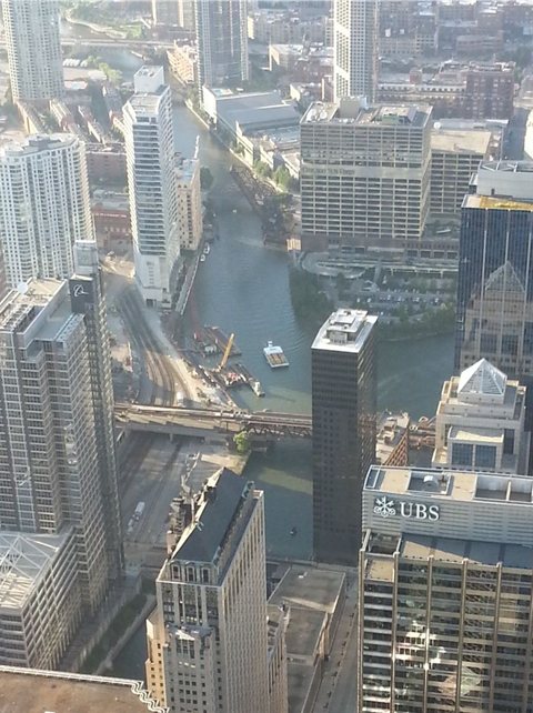
View of Wolf Point, where the North Branch of the Chicago (upper left) is joined by Lake Michigan water entering via the Main Stem (upper left) which flow then south through the South Branch lined on both sides by office towers. (2013)
The industrial character of the Chicago River peaks during winter months when up to 75 percent of the flow coming from the Chicago River’s North Branch is attributable to the discharge of treated sewage from the North Side Water Reclamation plant. The continued use of Chicago’s urban rivers as a conveyance system rather than an amenity or ecological feature represents not just a missed opportunity but something that has negative ecological impacts on Lake Michigan and the Great Lakes as a whole, with the continuous diversion of approximately 3.9 cubic meters per second of water from Lake Michigan and the rivers serving as a potential physical pathway through which invasive species (most notably, Asian Carp) could migrate from the Mississippi River watershed.
Although Chicago completed a deep tunnel system of its own in 2006 with a storage capacity of 2.3 billion gallons, the system at present is capable of capturing the discharge from only about 93 percent of the storm events that occur in an average year. Storms that exceed the design capacity are any with more than approximately 1.5 inches of rain. This results in the continued discharge of untreated mixture of stormwater and sanitary waste into Chicago’s rivers and Lake Michigan, on a scale that vastly exceeds discharges in Milwaukee (with over 11 billion gallons released during a prolonged storm event in 2008 – more than the combined total overflows from Milwaukee’s system over the previous decade). Although work is continuing on three above-ground reservoirs that will add 17.5 billion gallons of storage capacity, this work is not scheduled for final completion until 2029.
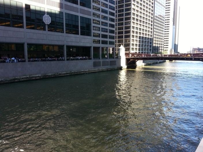
View of the South Branch, with no pedestrian access to the Chicago River in the shadow of 50- to 60-story high rises. (2013)
Chicago’s size and greater political influence are factors that may have enabled the city to postpone confronting the need to implement more technologically advanced, sustainable, and environmentally-sound methods for handling its wastewater and stormwater, and modernizing its bulk cargo transportation system. The costs for improvements necessary to address the Asian Carp threat have been estimated at $4.25 billion to over $15 billion, as reported in a 2014 article in the Milwaukee Journal Sentinel. Based on the ongoing fiscal crisis in Chicago, these or other improvements at best will likely require several decades to compete.
The lack of physical improvements along Chicago’s urban rivers during the past 20 years, at a time during which the city experienced one of the greatest downtown residential construction booms in U.S. history, is almost shocking to a visitor from Milwaukee. Within the shadow of new residential towers, vast stretches of the South Chicago River are currently bordered by vacant land. Chicago’s downtown riverfront provides the best evidence that the type of development that occurred along Milwaukee’s rivers was by no means assured or simply a reflection of a national trend, but instead is something attributable to a unique local commitment to environmental improvement.
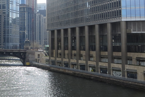
In spite of the $1 billion spent constructing the 98-story Trump Tower, public access along the riverfront pales in comparison to almost any section of the Milwaukee Riverwalk. (2013)
Although Chicago is in the process of completing a $100 million project that will greatly improve public access and amenities along the one-mile segment of the main branch of the Chicago River, this project was made possible only thanks to a federal Transportation Infrastructure Innovation Act (TIFIA) program loan announced in late 2013. Other sections of Chicago’s downtown riverfront remain completely inaccessible to pedestrians. And Chicago’s funding approach is far less sustainable than that used in Milwaukee, where 30 percent of costs have been paid for by private developers, and where public debt has generally been issued only in conjunction with new private developments that are assured of generating the tax increment necessary to pay for each segment of new RiverWalk construction.
Detroit’s Problems and Promise
View of the redeveloped one-mile section of downtown Detroit riverfront. Photo courtesy of the U.S.G.S.
Vacant and active heavy industrial land along the 7-mile section of riverfront to the west of downtown. Photo courtesy of the U.S.G.S.
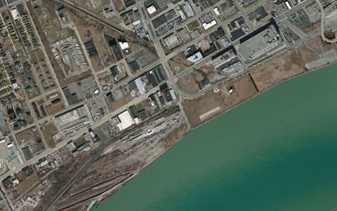
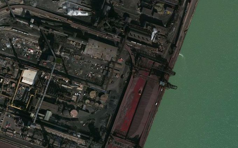
Waterfront areas on the Detroit River have been the primary focus for downtown revitalization efforts since the 1970s. These efforts included construction of the Renaissance Center, Cobo Convention Center, and Joe Louis Arena, as well as an approximately one-mile section of riverwalk. The waterfront to the east and north of downtown also shows significant promise, with several significant redevelopment projects, a high-quality recreational/natural area in the River (Belle Isle) and much of the waterfront already occupied by residential neighborhoods. Another positive is that Detroit’s downtown waterfront (like Milwaukee’s) is not separated from the downtown by highways (as is the case in Chicago, Cleveland, Buffalo, Cincinnati, St. Louis, Seattle, and many other cities). A third positive is that (like Milwaukee several decades ago) the extensive sections of vacant former industrial land bordering the waterfront could be more easily converted to high-quality uses that include public access than waterfront land in other cities now occupied by freeways, active industrial facilities, or infrastructure that would be costly to relocate.
Vacant and active heavy industrial land along the 7-mile section of riverfront to the west of downtown. Photo courtesy of the U.S.G.S.
However, despite all these positives, the challenges in Detroit include all of the well-documented social, fiscal, and political problems plaguing the city as well as the sheer scale of blighted lands requiring transformation. In particular, to the west of downtown, the Detroit River waterfront is a continuous 7.5-mile long strip of vacant former industrial land or active heavy industrial facilities. Detroit also lacks the type of downtown estuaries and urban rivers in Milwaukee that have vastly expanded the length of Downtown and near-Downtown waterfront available for redevelopment. Although Detroit’s waterfront has the potential to be the focus for a redeveloped city, it will be many decades before any comparisons would likely with what exists at present in Milwaukee.
Article Continues - Pages: 1 2
Freshwater Mecca
-
Milwaukee’s Extraordinary Freshwater Future
 Feb 20th, 2015 by David Holmes
-
Milwaukee’s Riverwalk Vs. San Antonio’s
 Feb 4th, 2015 by David Holmes
-
Milwaukee’s Clean Water Advantage
 Jan 21st, 2015 by David Holmes


Despite all this, won’t the Streetcar bankrupt Milwaukee and eventually Wisconsin? All kidding aside, great article!
Having traveled less than extensively and more than rarely, I have a sense that Milwaukee is doing something special and moving forward slowly but steadily in a positive direction. I think people here in WI & MKE take for granted what is happening… I think it’s something about being surrounded on 2 sides by Great Lakes that makes us all a little insular.
This may be off topic, but I’m so frustrated by the constant daggers thrown at Milwaukee when I see so much positive happening. I agree Tim…. we take for granted what is a beautiful and livable city. I know we have our issues with crime, poverty, education… etc., but there are so many committed people here working hard to improve life for everyone. We live in a post industrial city and if you were around here in the 70’s you would understand how far we had to go to get to this point.
As a resident of Milwaukee, I meet people every day from all walks of life. Everyone has an opinion depending on their circumstances and that’s great. What troubles me is the efforts by some, for political reasons only, to tear the city apart, to place blame where it doesn’t belong and to drive wedges between people that should be working together to solve problems. .
Great article. It is frustrating to visit these other cities and see how much of their waterfront is inaccessible. Do we have the Milwaukee socialists to thank?
David, thanks for your thorough research and broad perspectives comparing various Great Lakes cities. This info can help inspire Milwaukeeans to continue following a smart, sustainable approach to development. I was not aware of the extent to which Milwaukee is so unique, both for its accessible preserved lakefront and revitalized riverfront and clean rivers.
Bruce, the Milwaukee Socialists (from 1890s till 1960) do deserve some thanks for their vision and nuts-and-bolts good, clean government. The term “Sewer Socialists” was given to those early pragmatists who made sure good sanitation was put in place as the industrial era geared up.
Far-sighted city planners had already started setting aside parkland by then. They hired Frederick Law Olmsted in the early 1890s to design Lake, Riverside & Washington Parks & Newberry Blvd (when he was working in Chicago on the Columbia Exhibition World’s Fair). Of course, New Urbanists and preservationists have been working to keep our natural treasures and make the most of them.
Thanks for another installment of this brilliant series.
I wouldn’t credit Milwaukee’s successes, and they can be counted on one hand, to far-sighted city plannning, although they have been cautious in their process of decison making. Many scars have occurred from planning decisions from individulals that are NOT experts in their fields. i.e Erie Plaza, Bay View Bus Stop, Park East corriodr, etc. Is the streetcar next on that list?
Great article! Very informative. Having lived in the Buffalo, Chicago and Milwaukee and spent time in Cleveland and Detroit,I definitely support you view about Milwaukee being the most progressive in regards to waterfront development and accessibility. From the early urban parkway planning of Olmsted to the New Urbanism of former mayor John Nordquist, Milwaukee has done it right and hopefully continues to do so long into the future…
Great read! I have lived on the East side since 74. I love this city and remember the blight of the 70’s and 80’s and the progress that has been made. Unfortunately I will be moving when I retire due to the high property tax.
Apples and oranges when comparing Chicago to Milwaukee. Chicago’s waterways are a FEDERAL interstate and Milwaukee’s a cul-de-sac. The first act of Congress under the USC was reaffirmation of The Northwest Ordinance. All tributaries of the St. Lawrence, Mississippi AND it’s CARRYING POINTS (ie: Chicago Canals) shall be forever free and COMMON HIGHWAYS. Wow… Waterway precedent going all the way back to the very first act of congress in 1789! Whoever came up with the rubbish that this is a post-industrial world? Chicago is still an industrial city and it’s waterways are the backbone of it’s industrial economy. Like I said, the Chicago Area Waterway’s (CAW’s) are a waterborne interstate to the world. The CAW’s made Chicago and it’s still defining Chicago. You don’t build condos and golf courses along an interstate… A federal waterway interstate that is defined by industrial commerce. NEWSFLASH: You will always need somebody to ship the bulk comodities to market. The inland waterways are still the cheapest way to ship products to market. AND unlike the Seaway, Chicago’s other waterborne door to the world is open year ’round. Barges and tonnage on The CAW’s move even through the thickest ice. Once an ancillary transportation system is becoming more and more intermodal with rail and truck. That’s what places like Milwaukee and Detroit need to be afraid of in a highly competitive national & global economy. Winner take all.
You dreamers will always need somebody to pay the bills and drive the industrial ecomony. Chicago is still a working city with two waterborne doors to the world. The only city on the Great Lakes you can compare Chicago to is Toronto. Would Toronto advocate closing the Seaway… You have to be kidding.
This is all coming from me, a person who grew up in Buffalo, New York. @ one time the two biggest cities on The Lakes were Chicago and Buffalo. Since 1959 and the Seaway, it’s now Chicago and Toronto. Buffalo has now become “Radiator Springs” within the interlake and global transportation system thanks to the Seaway.
Again… You simply can’t compare apples with oranges. Federal interstates with cul-de-sacs. A state like Indiana and it’s ports on Lake Michigan and the Ohio River stand to lose 1.7 Billion dollars a year if the CAW’s is separated from The Lakes. They can have development and riverwalks in downtown Chicago… BUT, residential and recreational development simply does not soley define a place like Chicago like it defines cul-de-sacs like Milwaukee. Industry and recreational/residential interests need to co-exist in a place like Chicago.
Take a look @ this. 10’s of MILLIONS of tons transit the CAW’s each year… And it co-exists with 10’s of 1,000’s of recreational/pleasure craft.
http://www.iowadot.gov/compare.pdf
Chicago is a market center. In our streamlined transportation system, there is only one other market center on The Lakes: Toronto, Ontario. Milwaukee, Detroit, Buffalo, Cleveland are simply not in this league ANYMORE… Detroit was the last to fall. Milwaukee still clings to Chicago’s other door to the world. These cities were waterborne transportational hubs @ one time, but the systems are streamlined now and depend heavily on a city’s global positioning. Milwaukee needs to go the route it is going… Chicago doesn’t need to be all in. I am not going to say this article is insane, it is not… But, it is clueless to what actually is happening out there in the real, working, industrial world. We are the “bread basket” of the world because of the Inland Waterways and if we don’t start getting our collective heads out of you know what, that ag industry will shift to places like The Amazon River… It already is. I am not anti-green, but I am totally not anti-industry… We need industry to pay the bills. We chase it off in the name of going green, we will just pollute other places in the world 1,000 fold more!
This is a reply to Victor above in comment #8. If you are leaving because of high property taxes, who else is leaving? How is this residential/recreational & green model sustainable if you are not sticking around and paying the taxes? Who’s paying the bills?
Don’t get me wrong, it’s great what Milwaukee is doing and it works for Milwaukee. Yet, what’s going to happen when taxes go through the roof and industry doesn’t exist. How can people take vacations, become tourists when there are no good paying industry jobs. Mimimum wage @ riverwalk bistro hustling 5 dollar lattes can only get a city so far. As in Victor’s case… When he retires and actually has time to recreate, he’s leaving for lower taxes! WOW!
Thanks everyone for reading and for all of the positive comments,
Thamus (regarding comment 9):
My comparison of Milwaukee to Chicago was for the downtown and near downtown rivers that in Milwaukee, have undergone a dramatic transformation. Milwaukee’s Harbor and estuary are also subject to federal jurisdiction even if you would view them as a cul-de-sac relative to the Chicago Area Waterway System (CAWS).
I will confess to not having fully investigated all of the details regarding the operation of the CAWS. Therefore, I spent some time reviewing a report published in 2012 by the Great Lakes Commission on an Evaluation of Physical Separation Alternatives for the Great Lakes and Mississippi River basins by way of the CAWS. This report includes a comprehensive analysis of all functions of the CAWS.
According to this report, the total freight handled by CAWS of about 16 million tons represents only about 3% of the total freight moving through Chicago each year (67% is moved by truck and 30% by rail). What I suspected, but did not previously confirm, was that the vast majority of freight moving through CAWS is shipped through the Calumet Harbor via the Calumet SAG Channel rather than through the Chicago River. It appears that the amount of freight shipped by water through the downtown and the Chicago Harbor Lock is less than 1% of the total shipped through CAWS (or about 102,000 tons of cargo in 2010). Therefore, the economic benefits from continued use of the Chicago River for moving freight would seem to be pretty small relative to the opportunity cost associated with not having developed these portion of Chicago’s freshwater landscape in a manner comparable to Milwaukee.
Even if Chicago were to end use of the Chicago River in the downtown area for shipping of freight of other industrial uses, Chicago would hardly be lacking in industrial waterfront areas, with nearly the entire south end of Lake Michigan still dominated by industrial infrastructure and industrial facilities (from Burns Harbor through South Chicago) as well as nearly the entirety of the Calumet River and the Chicago Sanitary and Shipping Canal. There are probably thousands of acres of this land, where the waterfront location is no longer essential to the operation of the industrial facility, as well as thousands of acres of land that are vacant brownfields serving no economic purpose.
Although the transformation of Milwaukee’s waterfront areas is attracting billions of dollars of residential, office, and mixed use development, this has not been at the expense of the industrial economy. The Menomonee Valley area presents a great example for Chicago and other cities where industrial area has been revitalized for new industrial uses that now include quality of life amenities available to the workers in these facilities.
Milwaukee’s industrial present is alive and well and involved in many ways with the water initiative and the transformation of Milwaukee’s waterfront landscape. There are at least seven Fortune 1000 manufacturing companies based in Milwaukee with their headquarters or major facilities located within 2 miles of the Global Water Center. These include Johnson Controls, Rockwell Automation (located two blocks west of the School of Freshwater Science), Joy Global (overlooking the Hank Aaron Trail and Menomonee River), Rexnord Corporation (which moved its headquarters into the Global Water Center), A.O. Smith (with a research facility in the Global Water Center), Harley Davidson (which built its Museum on the a lot surrounded on three sides by the Menomonee River and Canal), and Gardner Denver (which just moved its headquarters to a location a half block from the Milwaukee River). The water initiative and/or quality of life amenities for workers at these companies (such as the revitalized waterfront landscape located in close proximity to their facilities) is most certainly relevant to these industrial companies and their competing and succeeding in the “real, working, industrial world.”
Thanks for the reply. A lot of what you said is informative yet, only tells one side of the story. Right now as I post, the lock on the Calumet River (O’Brien Lock) is closed for repairs. There were two seperate closures for about 45 days each. The first closure was from November to Decemeber. From mid-December to mid-January, the lock was reopened and freight was passed. The second closure was started on January 21st and is currently ongoing till around March 11th. Right now, all the freight is moving through the Chicago Harbor Lock. Hundreds of barges have passed through Chicago Harbor since the closure on January 21, 2015. The first closure, the same thing happened. When the numbers come out for 2014 and 2015, you will see a big jump in Chicago Harbor Lock’s tonnage. Of course this is a departure from Chicago Harbor Lock’s normal traffic of recreational craft and passenger vessels… BUT, they play a vital role in being a backup route/detour when one part of the CAWs is down for repair or closed to navigation… Just as O’Brien Lock and Dam does. Of course navigation is just one mission for the CAWs. There is also flood control, sanitary, and water diversion. The system is bought and payed for the most part. The O’Brien Lock was built in 1960 for 6 million dollars tacked on to Seaway appropriations. Right now a 60 day closure costs the economy/business 18 million dollars. That’s bang for our federal taxpayer’s buck! The CAWs is one of the few things in gov’t turning a profit and paying the bills… And they want to separate it for a huge taxpayer cost that has very weak ROI. Then, taxpayers like Victor above will leave the area because the taxes are too high?
I ask the question, what happens when one part of the CAWs is down for repair? The Inland Waterways and its connection to the CAW’s is vital in many ways to the economic health of the area and the nation. As a “common highway” “forever free” it can’t be choked off w/development or spearated from the Great Lakes. Part of this waterway “interstate” also plays an important part when it comes to the 10’s of thousands yearly recreational craft and passenger vessels transiting the area. The CAWs is the only way to enter the Inland Waterways to and from the Great Lakes (western end). The CAWs is vital and needs both Chicago Harbor and Calumet Harbor to function properly… It’s Chicago’s waterborne door to the world. The southern vessels that play all summer long in Milwaukee transit the CAWs to get to Milwaukee and other points on The Lakes. Chicago Harbor Lock is one of the busiest locks in the country.
The 3% in freight might seem small, but it represents a very important ancillary (which is becoming more intergrated into modern intermodal shipping systems) mode of transportation especially for bulk commodities that would be difficult to ship by rail/truck. Once the figure out the container condundrum, I am sure the intermodal freight facilites will become more important. The CAWs also represents an important avenue for ovesized shipments that can’t be shipped any other way. Shipments that are vital to national security. Also, factor in what the New Panama Canal will bring to the Inland Waterways. The system in Chicago is working perfectly fine, even with all that “wasted space.”
Again, thank you for the reply. Please don’t interpret my comments as being negative. Again, Chicago is in league of it’s own. What works for Milwaukee is great and Milwaukee should take pride in that without having to compare itself with other cities… Especially Chicago. Cities like Buffalo, Cleveland, and Detroit do need to look @ what Milwaukee is doing right.
Please excuse all the typos, poor spelling, etc… My quick reply was intended not to take away from anything positive Milwaukee is doing. I mentioned my roots to Buffalo and how hard they are trying to turn things around. Buffalo could learn a lot from Milwaukee. I do see the environmental agenda though. Chicago simply works differently and always will. Chicago will change, but it will change around what it needs, not because what others are doing. Again, its river systems simply operate differently. This will be my last reply so there can be more constructive thoughts on the very interesting article written.
Thanks Thamus. You make a lot of good points. The balance between new residential and recreational uses and existing industrial uses is a challenge for Milwaukee’s waterfront areas as well. In nearly all instances that I can recall, the City has been adamant about retaining industrial jobs (and maintaining the key transportation infrastructure provided by the Port of Milwaukee) even when these are located in waterfront areas that might otherwise be attractive for non-industrial development. The updated plan for the Menomonee Valley rejects any residential use in much of the Valley. So far, the focus on retaining established industrial companies does not seem to have impeded the significant progress in enhancing the waterfront areas. The School of Freshwater Science has coexisted with a bulk liquid asphalt storage facility on one side and a coal storage facility on the other. The coal piles will soon be departing with the conversion of a nearby power plant to gas, at which point the coal storage property will finally transition from 100+ years of industrial use to what will likely be a cleaner non-industrial use. Everything in its time….
Nearly all of the residential and other new development in waterfront areas in Milwaukee has occurred on vacant former industrial parcels or in vacant or underutilized former industrial buildings. I think the key perspective for Milwaukee that I wanted to bring through the comparison with Chicago is that the riverfront revitalization that occurred in Milwaukee was not something that was inevitable but was due to a unique set of circumstances that included a decades earlier cleanup of the river, the foresight to create the Riverwalk network, and the opportunity presented by the industrial decline and the abandonment of large sections of the riverfront by industries.