
The Port of Milwaukee Interchange Is an Overbuilt Mess
Simplified traffic connections could yield new land while better connecting to city.
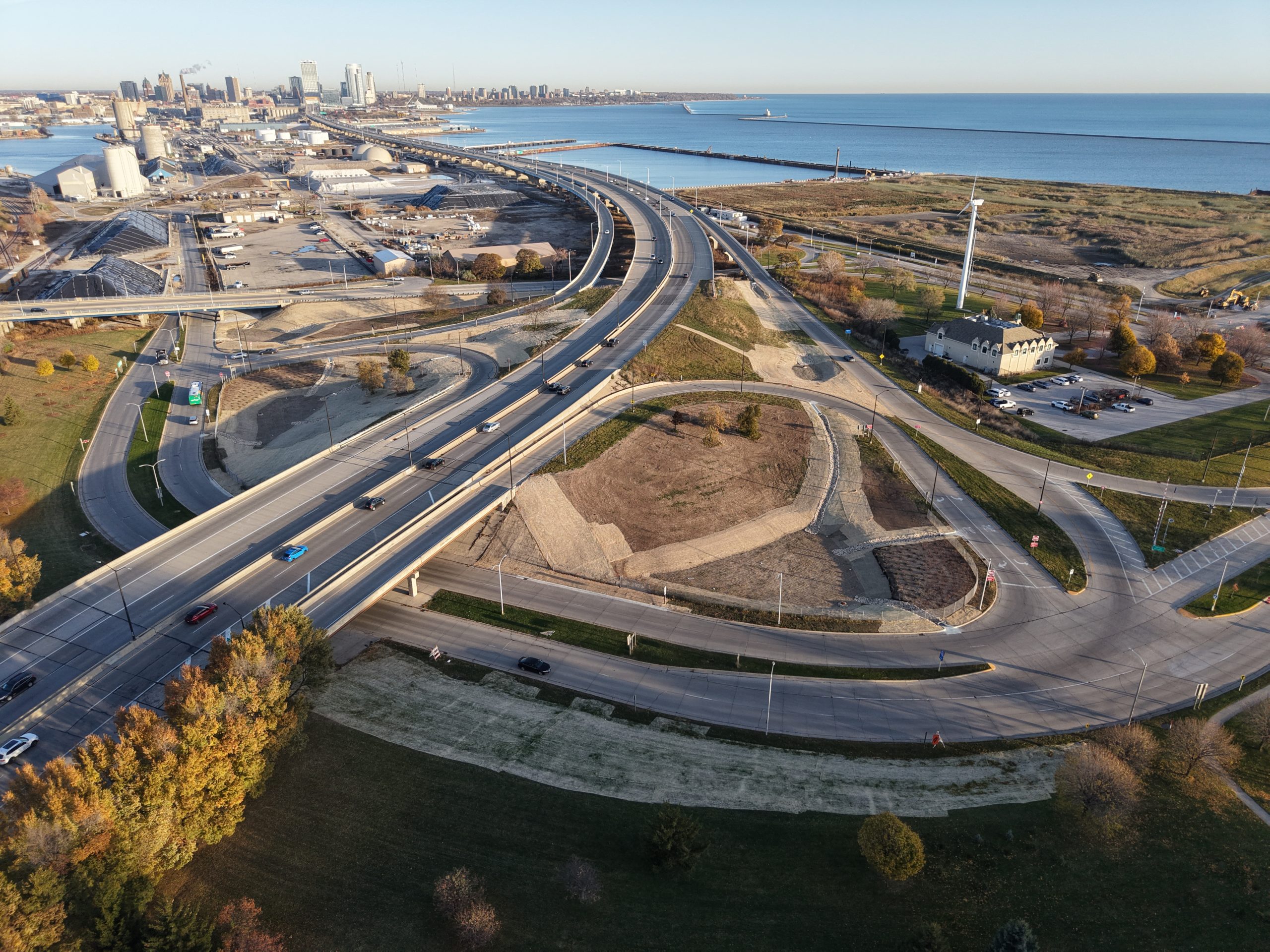
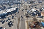
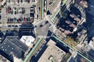
Port ramps at Wisconsin Highway 794. Photo by Urban Milwaukee staff.
The Port of Milwaukee interchange at the southern base of the Hoan Bridge is a vestige of the city’s overbuilt road infrastructure that is both inconvenient and inefficient.
Instead of offering direct access to Bay View or to industrial sites to the north of Bay Street, vehicles must pass through a web of overbuilt roads and antiquated ramps. Volumes of vehicle and rail traffic are low and don’t require the lane capacity and overpasses, which create barriers to direct connectivity to Lincoln Avenue in Bay View. This convoluted traffic pattern is also largely without infrastructure for pedestrians or bikes and separates the northern core of Bay View from I-794 and the lakefront. Meaningful fixes could help restore the street grid, improve connectivity, open up land for green space or industrial development and reduce long term costs for the city.
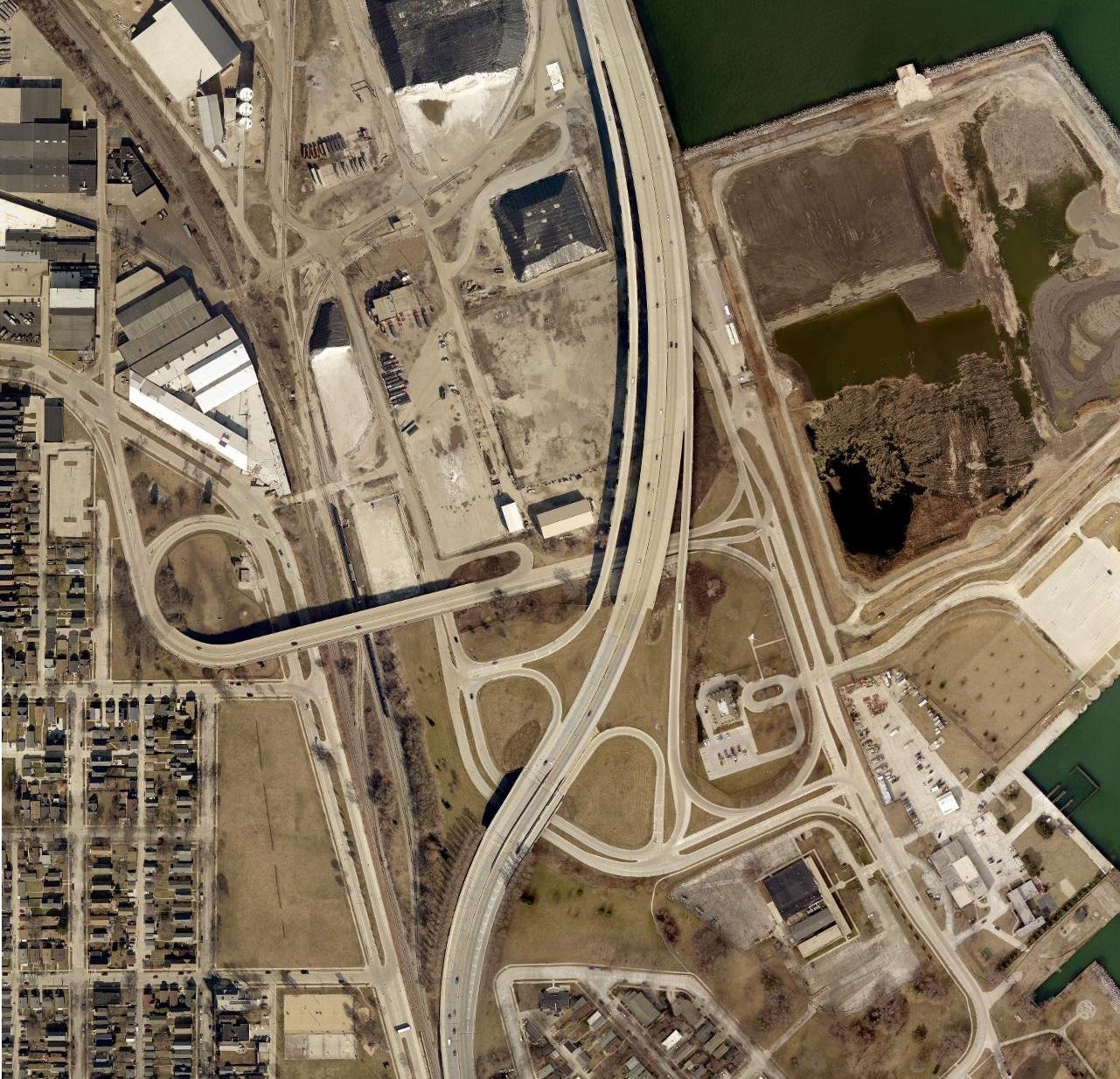
Figure 1: The existing Port of Milwaukee interchange in its current form.
The Hoan Bridge is a tied-arch closed access bridge spanning Milwaukee’s inner harbor that connects Bay View, St. Francis, Cudahy and South Milwaukee to Downtown. Construction took place from 1970 to 1972, but due to freeway revolts and delays in constructing connecting roadways, the bridge didn’t open to traffic until 1977. Until the opening of the Lake Parkway in 1999, the Port of Milwaukee interchange was the terminus of the bridge. Traffic entered and exited the southern end of the bridge at Carferry Drive, which connects to the port, South Lincoln Memorial Drive and the Lincoln Avenue Viaduct. Carferry Drive and the Lincoln Avenue Viaduct were built as boulevards to accommodate the highway traffic, which never materialized the way traffic planners imagined. The resultant network of roads is overbuilt for its number of daily users and is an inefficient use of space.
The interchange is built on what was once the Bay View Rolling Mill. The mill opened in 1868 and became an important center of iron and steel production. Thousands worked at the mill over the decades, and it became a major driver of the transformation of Bay View from a largely rural area to a densely built urban neighborhood. The mill closed in 1929 and the land was cleared a decade later. It remained fallow, an expanse of tall grass and backfill, until the early 1950s when efforts were undertaken to modernize and expand the Port of Milwaukee.The Lincoln Avenue Viaduct was constructed on the northern edge of the mill site and opened to traffic in 1958. The viaduct was built to provide a modern and high-capacity access point between the rapidly expanding Port of Milwaukee and newly widened Bay Street, which would ultimately connect to a not-yet-built I-94. But with the eventual construction and opening of I-794, the bridge became a secondary access point for port truck traffic. In 1977, Carferry Drive was rebuilt and widened into a boulevard with the completion of the Hoan Bridge. An uncomfortably tight loop ramp was added to the northern edge of Carferry Drive in 1990, connecting it to the Lincoln Avenue Viaduct.
The Lincoln Avenue Viaduct replaced the at-grade crossing at E. Bay Street, which has since been privatized but remains an at-grade crossing for the industrial property owner. To the south of the interchange, Conway Street once crossed the Union Pacific railroad tracks, but that crossing was closed to vehicles with the opening of the viaduct in the late 1950s. Pedestrian access remained available until the construction of the Lake Parkway in the early 1990s. With the construction of the parkway, pedestrians could cross the two parts of Bay View either over the viaduct or at the underpass at Russell, a distance of nearly half a mile. The resultant parkway and railroad tracks act as a wall between these two halves of the neighborhood.
The Lincoln Avenue Viaduct underwent a full deck reconstruction in 2012, which included improvements to the bike and pedestrian infrastructure. The bridge is under the jurisdiction of the Wisconsin Department of Transportation. To improve pedestrian and bike connectivity, the state should add an ADA-compliant switchback entry from Lincoln and Logan onto the bridge. The city should work with the state to remove the secondary entry to Bay Street south, which cuts through the Bay View Dog Park. A single access point at Bay with new signalization is sufficient for the 3,300 daily vehicular users of the bridge. This would open space to expand the dog park, plant additional trees and reduce excessive asphalt without disrupting the truck route.
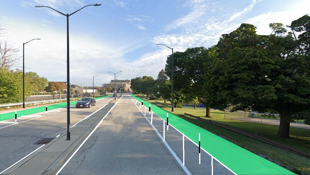
Figure 2: Rendering of the expanded Bay View Dog Park, the road loop to Bay Street south removed.
On the eastern side of the viaduct, the state should remove the ramp from Carferry Drive. As WisDOT considers the long-term future of 794, it should improve the existing ramp configuration at the interchange. The southbound exit ramp to the port should intersect with the Lincoln Avenue Viaduct at a signalized crossing. A new southbound entry ramp could open from the viaduct, replacing the existing confusing configuration that is both a tight turn and requires multiple wrong-way signs.
The northbound exit ramp from the Lake Parkway would intersect with the Lincoln Avenue Viaduct at a new signalized crossing and continue as an access ramp to South Lincoln Memorial Drive. South Lincoln Memorial Drive would be routed under the Hoan Bridge, connecting to the port while providing a new northbound on-ramp onto the bridge. Lincoln Memorial Drive could be constructed to cut through an existing salt pile site and connect to Harbor Drive, creating a more modern and attractive entry to the port and making it more easily accessible for trucks coming from 794 and Bay Street. This new configuration would render Carferry Drive duplicative and allow for its removal. In its place, a new parcel north of the Viaduct could be developed for industrial use, connected to the port’s activities. Perhaps it could even be the site of an exciting and expanded new salt pile!
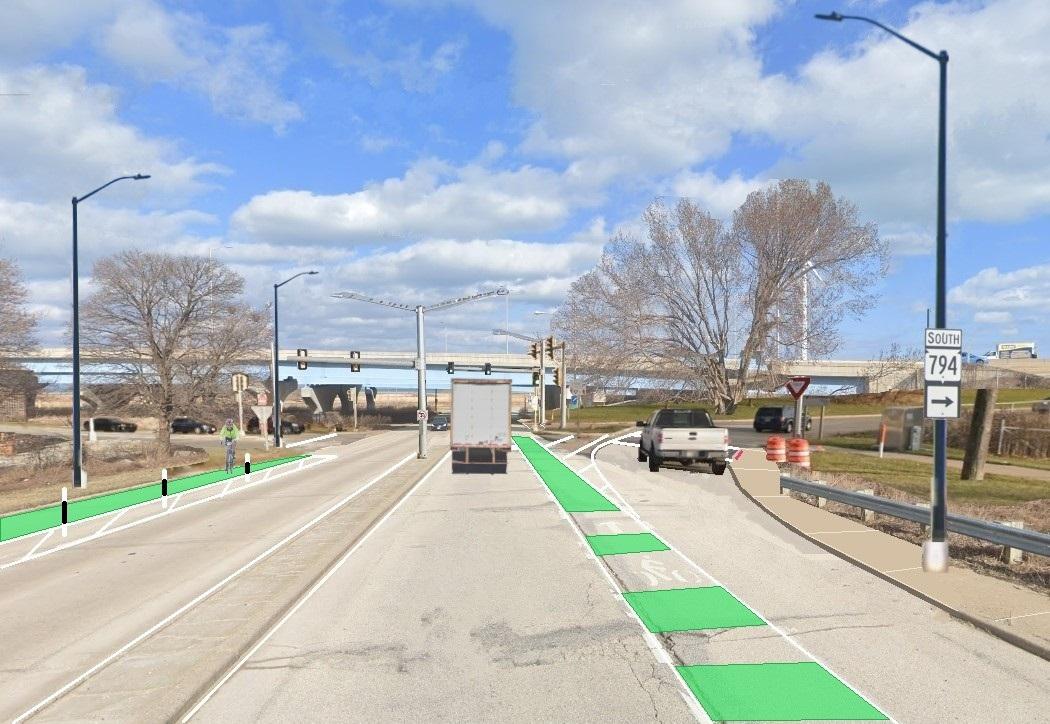
Figure 3: Rendering of a new signalized intersection with the southbound exit and entry ramps at 794 and the Lincoln Avenue Viaduct
The land currently occupied by the southbound ramps and Carferry Drive could be converted into a retention pond with native plantings. It would be an enhancement to the Milwaukee Metropolitan Sewerage District project currently underway on the land around the interchange. The area once hosted a creek, and with the risk of severe flood events increasing due to climate change, the retention pond could be an effective way to funnel excess water out of Bay View and into a natural basin. The most significant opportunity to emerge from this new configuration would be the new development site created north of Conway, bordered by the U.S. Marine Corps reserve base and the Port Milwaukee office sites. Since this land was once a rolling mill, it is likely not suitable for residential development, but could be suitable for a light industrial facility. Open sites near the area workforce and interstate highway ramps are highly attractive for industrial use.
The reconfiguration of these ramps could open nearly one million square feet of land to new green infrastructure and industrial sites, the latter of which could be added to the city’s tax rolls. The port is a high-intensity industrial district with several critical municipal and open uses, but it is deserving of a much easier and attractive access point. The city, working in conjunction with the state, could radically reimagine the interchange in a way that helps tie Bay View back together, ushers in new economic development and makes everyone’s trip a little easier.
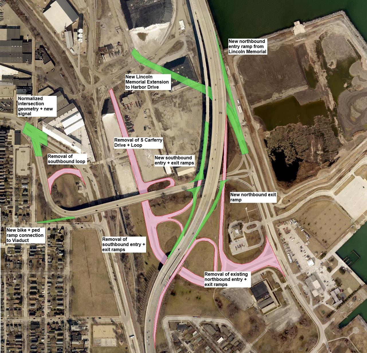
Figure 4: A diagram of the proposed reconfiguration. Red denotes pavement to be removed; green denotes new roads and ramps.
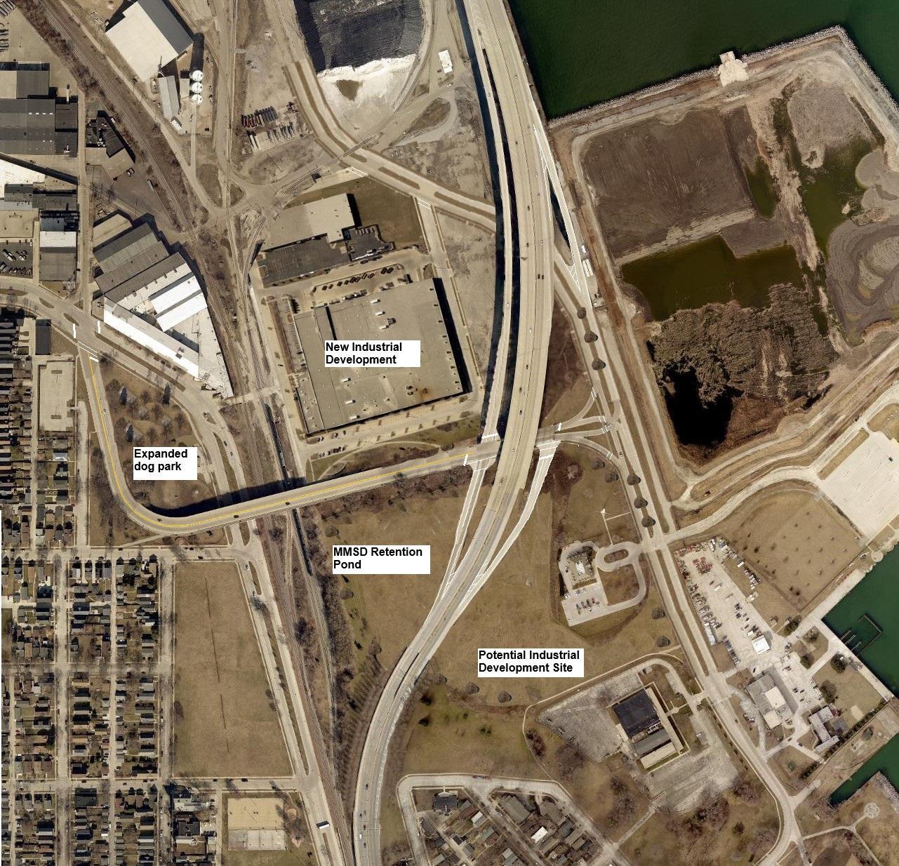
Figure 5: An aerial image of the interchange after the proposed reconfiguration with the expanded dog park and new industrial development.
Photos


Existing members must be signed in to see the interactive map. Sign in.
If you think stories like this are important, become a member of Urban Milwaukee and help support real, independent journalism. Plus you get some cool added benefits.
Intersection
-
The Bermuda Triangle of Milwaukee’s Northwest Side
 Feb 19th, 2026 by John O’Neill
-
6 Changes Needed on Commerce & North
 Aug 25th, 2017 by John O’Neill
-
Farwell and Brady Need Changes
 Mar 30th, 2017 by John O’Neill


Thanks for this wonderful article explaining how sensible reparation of the gross mistakes of traffic planners can make more property available for industry and ecology.
I can’t remember if the article about the ridiculous “interchange” at I-94 and National Ave. was here on Urban Milwaukee or elsewhere, but there’s another spot screaming for a major diet.
Milwaukee’s’ freeways (as was the case in every other city) displaced tens of thousands of families and businesses with disregard for, life, livelihood, community, or any for of traffic besides automobiles. I get the value of highways and the Interstate system, but traffic planners went way overboard in cities, and still do.
It’s high time the mistakes of the past be repaired for those of us here today and for future citizens.
I drive on this cluster of circles often. Direct access to/from 794 to/from the viaduct is a no-brainer.
We absolutely need the bike infrastructure, but let me point out that the rendering of just paint on pavement with plastic bollards is total trash and should never be how we build that infrastructure moving forward. *Protected* infrastructure for bikes and scooters, like how there is on Wells, Walnut, etc is how all bike infrastructure should be built from now on. When I’m driving my car and passing a bicycle with nothing separating us but paint, there’s a level of anxiety I would not have if we were separated by protected infrastructure like cars are from pedestrians.
Otherwise I absolutely love this idea. We need to reduce the footprint. That’s a lot of land value that is sitting completely empty.
The amount of high value land that Milwaukee has dedicated to massively overbuilt car infrastructure that generates $0 of property tax is insane.
Well WOW. Thanks for this fantastic in-depth reporting.
Excellent exercise and love it! One question, how do trucks from the Port get to NB 794? All I see for that is a very tight u-turn along LMD.
Cheapest solution: Just continue E Lincoln Ave at grade eastward to Carferry Dr. There’s rarely a train on those tracks and it would pretty much line up with the existing ramps. No big cost to do that compared to what is proposed here.
@CraigR – that was my thought as well, just remove the Lincoln viaduct and make the track crossing at-grade. Combine the ramp re-configuration with removal of the viaduct would open up land and reduce future roadway costs.
I would imagine the Marines could be tempted to move out of their rapidly aging legacy building to, for example, a more modern facility co-located in the Northside Army Reserve/Guard properties. Land swap with more fine industrial square footage.
“The resultant parkway and RR tracks acts as a wall between these two halves of the neighborhood.” I’d like to see built an additional access point across (or under) the Lake Parkway/Union Pacific RR tracks with placement say at Conway or across the street from the Beula Britten community center. I always felt the present configuration was a mistake especially since the community center was built.
The northern end of 794 is / should be greatly simplified with the coming 794 removal.
A tight diamond interchange is absolutely overkill for 794 here.
Get rid of the ramps and make it an at-grade intersection. Even a roundabout would be nice. Would be cheaper than building these new ramps, and would even open up money for further realigning 794 to maximize land for development.