
What’s That Orange Barrier in the Milwaukee River?
We Energies' project to dredge river bottom is part of much larger cleanup effort.
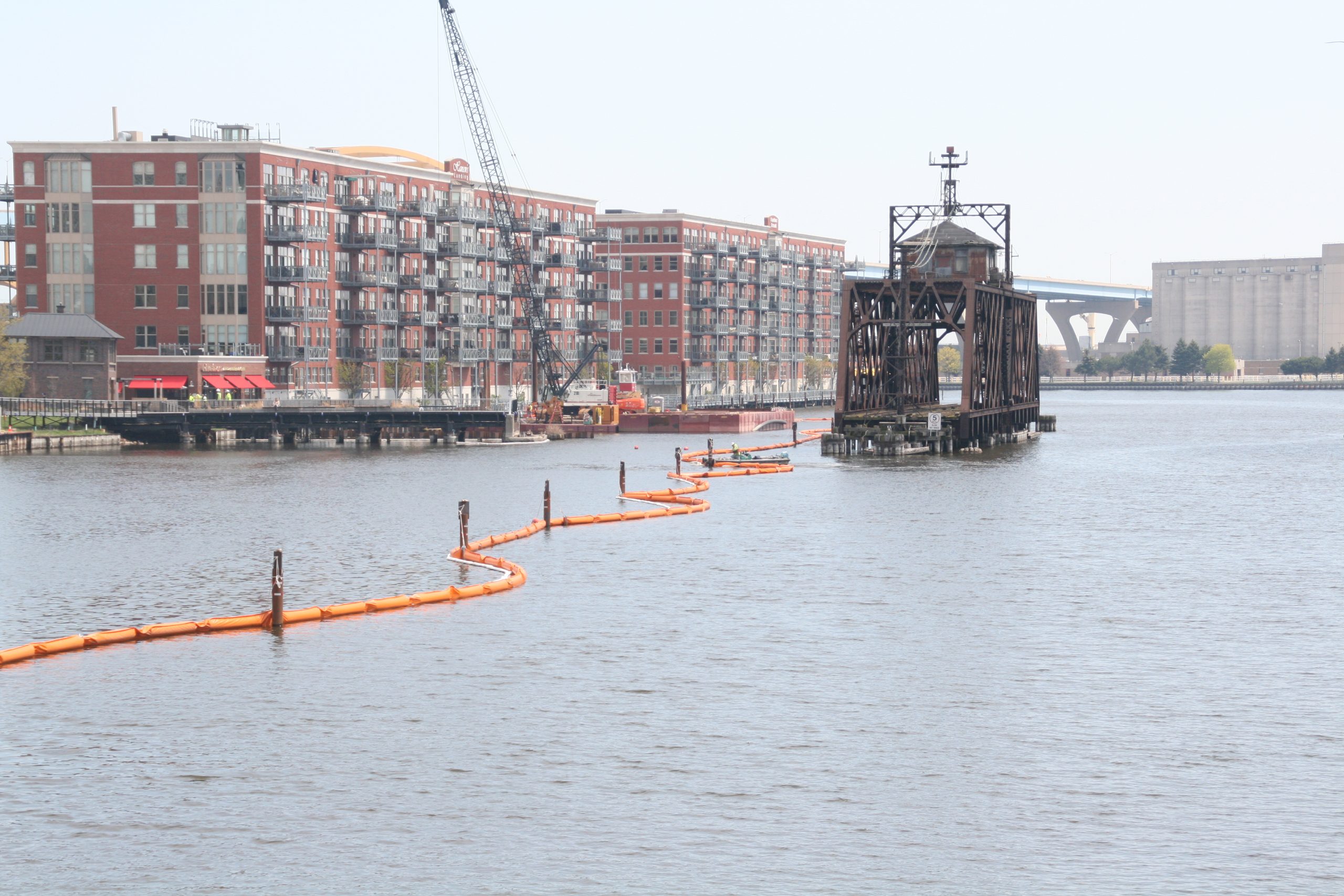
PCB cleanup in the Milwaukee River. Photo by Jeramey Jannene.
A busy portion of the Milwaukee River will look quite different this year. An environmental cleanup is underway that is intended to make all Milwaukee waterways more attractive for wildlife and recreation alike.
A crew is working to remove contaminated sediment from the bottom of more than a half mile of the Milwaukee River at the southern end of the Historic Third Ward.
The cleanup is part of a several-hundred-million-dollar initiative to clean up area waterways sufficient enough for the federal government to remove its “Area of Concern” designation. Known as the Waterway Restoration Partnership, the initiative was announced in January 2020 and the river cleanup is the first highly-visible piece of the effort.
We Energies, with contractors GEI Consultants and J.F. Brennan, is working to remove approximately 45,000 cubic yards of sediment from two spots on the river’s bottom. The largest area is a 0.6-mile stretch east of the Broadway Bridge. A small site just west of the Water Street Bridge is also being cleaned up.
Contractors will use hydraulic dredging, similar to an underwater vacuum, to remove the sediment. New steel sheet piles and a sand cap will be put into place to protect the area further.
The work is to be completed this year and is expected to cause temporary closures of adjoining Milwaukee RiverWalk segments while work is being actively performed. Boat traffic will still be allowed, although access to the work area is prohibited.
The contamination, polychlorinated biphenyls (PCBs), is from a gas manufacturing plant that was once located in the area. Owned by a We Energies’ predecessor, the plant was demolished in the late 1950s, but numerous references can still be found in local names like Gas Light Park and Gaslight Lofts.
Recovered sediment will be transferred to the existing Confined Disposal Facility (CDF), a man-made, concrete-protected storage facility near the southern end of the Hoan Bridge. Instead of using barges, the sediment is to be transferred using an underwater pipe.
The CDF, built in 1975, will be effectively full following the completion of the Third Ward project, necessitating the construction of a new facility to the north. The state, Milwaukee Metropolitan Sewerage District (MMSD) and the City of Milwaukee signed off on the funding for the Dredged Material Management Facility (DMMF) facility last year. The new facility could cost $150 million to build, with much of the funding from MMSD borrowing and federal support. The federal government is expected to provide at least $260 million to the larger effort.
The DMMF will eventually house 1.4 million cubic yards of sediment, the equivalent of 130,000 truckloads, from the cleanup project. Other planned projects will contribute an additional 500,000 cubic yards. Both the DMMF and CDF will be capped and dedicated for public use in the future, with the southern half of the CDF already capped.
The cleanup project is expected to last for at least the next five years. The Environmental Protection Agency anticipates delisting the Area of Concern in 2031.
First designated in 1987, the Milwaukee Estuary Area of Concern encompasses the Inner Harbor and portions of the Milwaukee, Menomonee and Kinnickinnic rivers. The area is roughly bounded by E. North Ave. to the north, W. Cleveland Ave. to the south, Lake Michigan to the east and N. 35th St. to the west. An expanded area of concern in 2008 includes the Milwaukee River to Cedarburg, the Little Menomonee River almost to the Mequon border, and the Kinnickinnic River to Greenfield.
There are five Areas of Concern in Wisconsin and 43 designated Areas of Concern in the Great Lakes, including 17 in Canada and seven shared by the U.S. and Canada. Nine of the areas have been successfully delisted.
A handful of other projects are at various stages of development, including the Grand Trunk site wetland restoration, a project to fill the Burnham Canal so it functions as a wetland and an effort to clean a sewer laden with PCBs from a contaminated plant in Riverwest.
Photos


If you think stories like this are important, become a member of Urban Milwaukee and help support real, independent journalism. Plus you get some cool added benefits.
More about the Area of Concern Abatement Effort
- New Mosaics Mark the Spot for River Cleanup Updates - Sophie Bolich - Jul 1st, 2026
- New Machine Quietly Cleans Milwaukee’s Water - Jeramey Jannene - Mar 21st, 2025
- Photo Gallery: New South Shore Park Beach Takes Shape - Graham Kilmer - Mar 14th, 2025
- MKE County: Effort Aims To Reduce E. Coli Closures at Bradford Beach - Graham Kilmer - Feb 27th, 2025
- MKE County: Habitat Restoration Planned in Kletzsch Park - Graham Kilmer - Feb 14th, 2025
- MKE County: County Deploying $1.3 Million in Environmental Cleanup Grants - Graham Kilmer - Sep 19th, 2024
- MKE County: Habitat Restoration Coming to Kohl Park - Graham Kilmer - Jan 12th, 2024
- MKE County: Largest Fish Barrier Between Grafton and Lake Michigan Removed - Graham Kilmer - Dec 21st, 2023
- EPA Giving Milwaukee $17 Million For Sewer Project - Evan Casey - Nov 2nd, 2023
- Cleanup Of Polluted Great Lakes Sites Reverses Housing Price Declines - Danielle Kaeding - Oct 19th, 2023
Read more about Area of Concern Abatement Effort here


My cousin was part of the Charles River mitigation project in Massachusetts 20(30?) years ago. Instead of laying down a layer of rocks and gravel to stabilize the riverbed, entombing the toxins, they too dredged. His crew taking water samples from a boat out in Boston Harbor had to wear Level B HazMat suits due to the huge quantity of PCBs the dredging stirred up and introduced to the water column.