New Development Plans for Streetcar
City details possible changes around a streetcar route to Walker's Point, Bronzeville, Harambee.
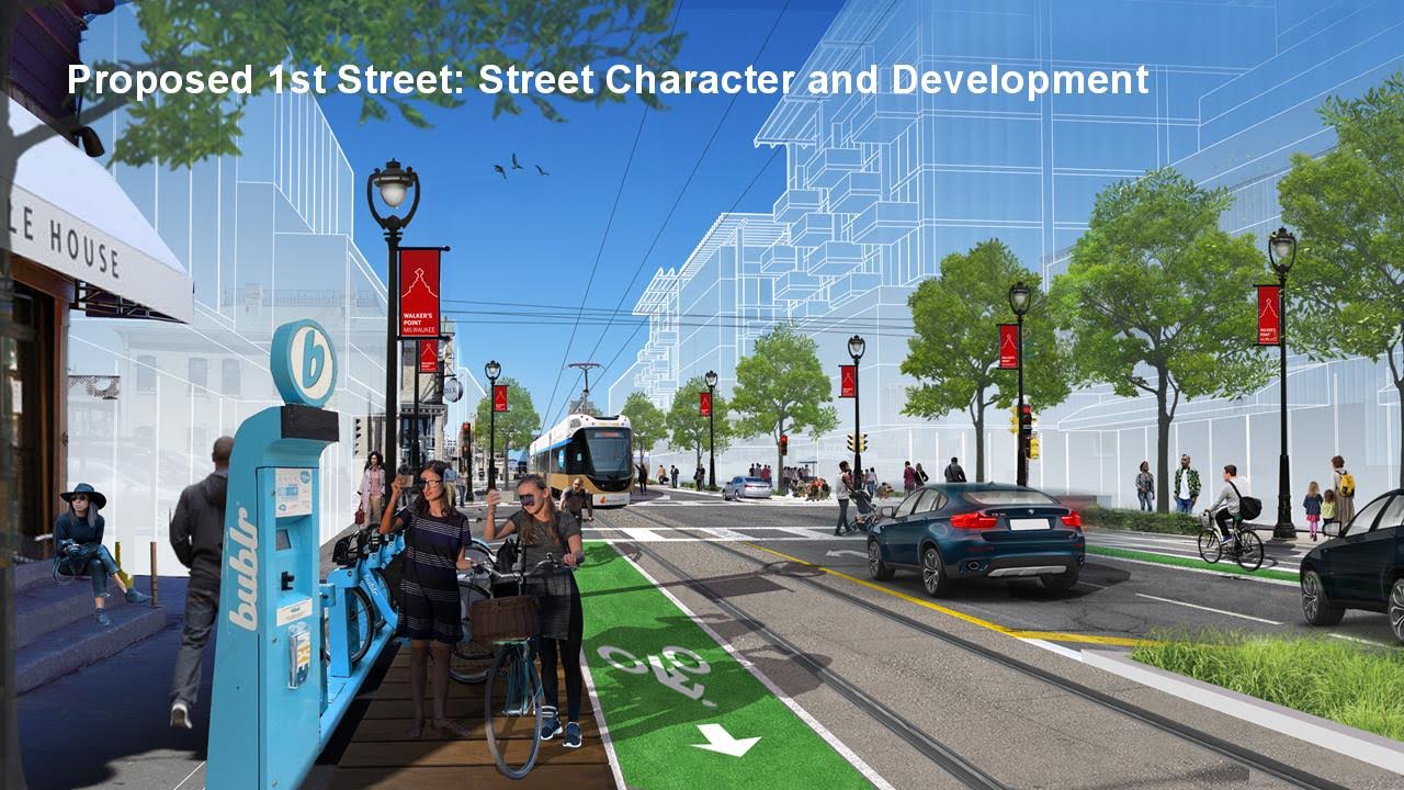
Walker’s Point Streetcar Rendering – S. 1st St. – Rendering by City of Milwaukee
While the actual extension of The Hop to the north and south is likely years away, the city has completed a planning process to study what development around stops in Bronzeville and Walker’s Point should look like.
Monday afternoon representatives of the project management team, led by the Department of City Development, presented the transit-oriented development plan to the City Plan Commission. Monica Wauck Smith walked the commission through a vision that would have the streetcar extending north from Downtown to W. North Ave. along N. Martin Luther King Jr. Dr. and south to E. Mitchell St. along S. 1st St.
She told the commission the study had a goal of creating a plan to extend investment from Downtown, connecting neighborhoods physically and economically, to enhance the local distinctiveness of neighborhoods and ensure that the existing communities benefit from any extensions through equitable and inclusive strategies. The results of the study will be incorporated into the city’s area plans for Walker’s Point and Bronzeville.
The plan, funded by a $750,000 federal grant, was created by lead consultant Skidmore, Owings and Merrill, with a number of subcontractors including local firms P3 Development Group. DAAR Engineering and Abrazo Marketing. The study team held 10 community workshops, five plan advisory group meetings and attended a number of community events to collect feedback from 1,800 people. “We wanted to make sure people did not feel that they would be moved out of the neighborhood,” said King Drive Business Improvement Bistrict director Deshea Agee. The King Drive BID and Harbor District both helped support the study effort.
Wauck Smith said that feedback in both Bronzeville and Walker’s Point supported providing more housing, including affordable housing, as well as preserving existing affordable housing and avoiding displacement. Community residents also expressed a desire for more commercial space and wanted vacant lots to be developed, so long as development stayed consist with the character of the neighborhood.
The plan prepared for Walker’s Point includes 1,500 to 2,000 new homes (primarily through multi-family buildings), 10 to 20 new storefronts and 3,000 to 4,000 new jobs primarily through the creation of new office space throughout the corridor.The Bronzeville plan envisions 1,500 to 2,000 new homes, 20 to 30 new storefronts and 1,500 to 2,500 new jobs. The plan also envisions up to four new community facilities in the corridor. Most of the development is envisioned to happen near two intersections, where N. Martin Luther King Jr. Dr. intersects with W. North Ave. and with W. McKinley Ave. Both intersections have seen increased development in recent years including the Bucks arena district just south of W. McKinley Ave. and a host of projects along W. North Ave. including the Pete’s Fruit Market grocery store and The Griot apartments.
Implementing the plan will include increasing the maximum and minimum building heights around proposed stops in the city’s zoning code. Wauck Smith also said the city could look at modifying the zoning code in those areas to better regulate building design. “This is kind of homework for the city,” said Wauck Smith about the consulting team’s recommendations.
Even if the streetcar never materializes, the plans are intended to create more walkable and transit-friendly places, said Wauck Smith. Both plans include changes to east-west running streets that intersect with the streetcar corridors to improve bicycle and pedestrian friendliness.
Wauck Smith told the commission that the city is seeking federal funds to support the expansion of the streetcar system into both neighborhoods. To connect to Bronzeville the city will first need to secure federal funds for an already approved extension up N. Vel R. Phillips Ave. to the arena district. The city, which leveraged long unused federal funds to build the system’s first phase, already secured a $14 million federal grant to build the extension to the lakefront.
The study did not include engineering work on the actual streetcar tracks and stations, both of which would still be required to build extensions to the north and south.
Displacement, Race and the State
City Plan Commissioner Darryl Johnson asked about planning efforts to prevent displacement, particularly among those on fixed incomes. “A lot of people refer back to what happened in Brewers Hill and how it could easily happen further north,” said Johnson. The Brewers Hill neighborhood, located just north of Downtown, experienced a surge in property values before the Great Recession.
“It is one of the things that was really challenging,” said Wauck Smith. “One thing that I learned doing this is that the city is really hamstrung doing this by the state. The state doesn’t allow us to cap senior citizen taxes… Some of those tools you see in other cities aren’t on the table for us unless the state makes changes.” Wauck Smith said the study also incorporates principles of the recently approved Anti-Displacement Plan.
Agee added that he’s seen the issue playing out in Walker’s Point already, even before the streetcar arrives. “On the South Side we’re finding that rents are going up and businesses are being displaced,” said Agee. He joked that the changes have led him to put on his “broker’s hat” and attempt to get those businesses to come to King Drive where rents are more affordable.
Daniel Adams, planning director at the Harbor District, said: “that was a big issue through our water and land use planning process, and it continued with this plan.” Adams said the problem is particularly acute with small manufacturers and artisans. “Much of our focus has been on preserving industrial zoning where we can,” said the planning director.Commissioner Joaquin Altoro had an even more complex question: “I know that there are nuanced differences in being black or brown in Milwaukee, and I’m always a believer that that should have an impact on how we design Milwaukee going forward… how has that impacted the work here?”
“That is a big question, but an important one,” answered Wauck Smith. She noted that every effort was made to make sure bilingual translators were available, as well as producing project materials in Spanish. She also said an effort was made to make sure the staff working on the study represented the races of the community they were working in. “That was very much on the forefront of our minds,” said Wauck Smith.
Agee added that having minority-led local firms work on the project was a sign that diversity was emphasized. “We want to make sure there is a component of black and brown on [real estate] development teams,” he said.
The plan commission unanimously endorsed the changes. More information about the study is available on MovingMKEForward.com.
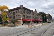
Renderings
Renderings of the proposed changes were released earlier this year.


If you think stories like this are important, become a member of Urban Milwaukee and help support real independent journalism. Plus you get some cool added benefits, all detailed here.
More about the Milwaukee Streetcar
For more project details, including the project timeline, financing, route and possible extensions, see our extensive past coverage.
- FTA Tells Milwaukee to Crack Down on Fare Evasion — Even Where Fares Don’t Exist - Graham Kilmer - Dec 12th, 2025
- Alderman, State Allies Seek Federal Help to Kill the Streetcar - Jeramey Jannene - Oct 28th, 2025
- Streetcar Service Suspended Following Truck Crash - Jeramey Jannene - Oct 21st, 2025
- One Alderman’s Quest To Defund The Streetcar - Jeramey Jannene - Oct 18th, 2025
- Another Streetcar Collision - Jeramey Jannene - Jun 27th, 2025
- Streetcar Hit By Apparent Red Light Runner - Jeramey Jannene - Jun 16th, 2025
- Streetcar Will Run On Consolidated Route During Summerfest - Jeramey Jannene - Jun 11th, 2025
- City Hall: Milwaukee Must Replace Failing Streetcar Switches - Jeramey Jannene - Feb 24th, 2025
- Streetcar Confronts Limited Funding, Operations Challenges - Evan Casey - Jan 22nd, 2025
- Council Kills Streetcar’s ‘Festivals Line’ - Jeramey Jannene - Jul 31st, 2024
Read more about Milwaukee Streetcar here
Eyes on Milwaukee
-
Church, Cupid Partner On Affordable Housing
 Dec 4th, 2023 by Jeramey Jannene
-
Downtown Building Sells For Nearly Twice Its Assessed Value
 Nov 12th, 2023 by Jeramey Jannene
-
Immigration Office Moving To 310W Building
 Oct 25th, 2023 by Jeramey Jannene
Transportation
-
Milwaukee Plans 60 Traffic Safety Projects for 2026
 Apr 8th, 2026 by Jeramey Jannene
-
State To Reveal New I-794 Cost Estimates
 Apr 7th, 2026 by Jeramey Jannene
-
Bus Riders Can Finally Pay With Credit Card
 Apr 6th, 2026 by Graham Kilmer