The Land of Brownfields
The 30th St. Corridor can’t succeed unless the contaminated land is healed. The process is already underway. Fifth story of a series.

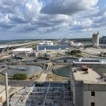
Aerial view of the 30th Street Corridor. Photo courtesy of the Redevelopment Authority City of Milwaukee.
Industries in Milwaukee were once concentrated along the lakefront and in Walker’s Point. Over time, industrial development moved west into the Menomonee Valley and then northward into what would become the 30th Street Corridor, and the industrial spine of the city. Then A.O. Smith “leapfrogged” out at the northern end, says Tory Kress, Senior Environmental Project Engineer for the Redevelopment Authority of the City of Milwaukee (RACM). Residential housing inevitably followed all this industrial development, as jobs were created.
Today, the task of cleaning up all the brownfields those industries left behind reverses their historic trajectory. Brownfield resolution begins in Century City because of its size and, at 74 acres, its development potential. Moving southward, the industrial sites get smaller and the solutions for them need to become more creative as RACM deals with small parcels and oddly-shaped lots.
The city purchased the Century City site in 2009. But before the purchase, they had already started assessing the environmental conditions there using a process called “all appropriate inquiry,” a process required for any property whose purchase will include funds from the federal Environmental Protection Agency. City officials knew they would have to purchase the site because they needed to take the lead on the development, but they were bolstered, says Kress, by the success they’d had in developing the Menomonee Valley.
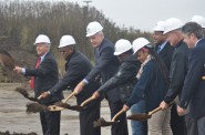
Cleaning up a brownfield is a complicated process. Not only must city officials package funding from state, federal and local resources, they must uncover the site’s history. They started, says Kress, by looking at the historical record of the site. What were the past claims that already existed with the DNR? What problems did they already know about? To facilitate the grant-writing process, they divided the property up into six sections: identified as A, B, C, D, E and F. Because there weren’t any structures there, cleanup began with section A, where General Capital is poised to break ground on Century City’s new building.
The project was divided into two phases, each funded by about $400,000 from the EPA and the state Department of Natural Resources. Margaret Brunette, who manages southeastern Wisconsin’s brownfield development for the DNR, says the project is being approached in pieces. “As the city gets funding, they’re working on it.” The first order of removal was the underground storage tanks. RACM reconciled their records with those of the DNR’s where there was a multiple record of contaminants.
Other problems cropped up, like storage tanks that didn’t exist in any of the records. As Kress says, “I suspect that there will be more surprises along the way.” As the property owner, she adds, RACM’s focus is on “how we can efficiently close out the site” as an environmental concern.
Some problems are straightforward. A tank full of chemicals, explains Kress, has only one resolution: they have to be removed. Spills are a more complicated problem. “If it’s a spill, we don’t know what that condition is now.” Some spills, she says, are naturally attenuating, meaning the impact of time and erosion has mitigated the environment damage. Milwaukee is fortunate, she says, because its water supply comes from Lake Michigan, not groundwater, so the state DNR can allow more leeway about the condition of those spills. The standards remain the same, but the time allowed for natural attenuation is a little more flexible.Site cleanup began with removing the buildings that weren’t slated to be saved. “Once we got all that junk out of there,” says Kress, the city was able to get a better look at the condition of the site. “Hot Spot evacuation” focused on concentrated contaminants that were excavated and trucked to an appropriate landfill. Because the area is being developed for industrial purposes, this means the city can use a capping option that may include some excavation but also allows for containment of the sites by covering them over with things like parking lots and foundations, protecting the area from the on-site exposure that happens when contaminated soil is excavated. Moreover, since future buildings will be for industrial use, they most likely won’t have basements, enabling the city to forego excavation by using the building’s foundation to cap the site. This strategy, says Kress, is “very development friendly.”
Right now, the city has a “pretty comprehensive set of soil and groundwater sampling,” Kress notes, “(but) we need to sample over time, and over seasons,” and as the groundwater in the area changes, to determine if the areas of concern are naturally attenuating. Continued cleanup of the site, he says, will be “dependent on the developments that are coming in.”
Further south, cleaning up the land becomes more complicated. South of Century City, there are 50 sites that are around an acre or less. Each one will require its own plan contingent upon its history, its current condition, and its proposed use. For example, the old Esser Paint site is slated to become a residential property. Residential requirements are different than industrial requirements, so that creates a need for other kinds of assessment and additional sources of funding. The first batch of proposals for the site, says Kress, revealed that potential developers were not all working from the same body of information about it. So city officials have put a hold on the Esser Paint project until they have a complete assessment to assure that “all the developers have the same understanding of the environmental issues,” Kress says.
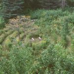
The scattershot way that the corridor evolved created oddly shaped lots—triangles that are less than an acre and unsuitable for any kind of commercial development, or National Hinge’s old site that is narrow and less than two acres and whose property line stops halfway down the slope to the Canadian Pacific rail corridor that gave the area its name. For sites like National Hinge, the city is open to any creative solution that fits within the mixed-use guidelines for the area, including those from urban agriculture organizations that see a one or two acre, weirdly-shaped lot that stops halfway down a hill as a perfect place for an urban farm.
When the factories departed from the 30th Street Corridor, not only did they leave behind empty buildings and brownfields, they left a lot of parking lots covered in impermeable pavement. All that non-porous surface contributed to the flooding problems that occurred in 2010, when 8.3 inches of rain descended on the city in a 24-hour period. According to the Milwaukee Metropolitan Sewerage District (MMSD), that event caused $32 million in damages to businesses in the northern end of the corridor.
The MMSD has a comprehensive plan for dealing with storm water and sewerage overflows in the corridor. They have a dropshaft to the Deep Tunnel in the 4100 block of N. 31st Street, which obligates them to use their financial resources to pay for remediation there. South of Capital Dr. is more complicated because the funding for that project must come from city, state and federal grants.
Kevin Shafer, Executive Director of MMSD, sees the stormwater and sewer issues not just as problem to solve, but as an opportunity to help restore 5.9 miles of blight in the corridor. “If we’re going to solve the problem, let’s not just put a pipe in the ground and have what we have now.” It’s the same approach MMSD used when they created the Menomonee Valley Storm Water Park that managed the problem there by restoring the natural landscape and then prompted the development of playing fields and the new Three Bridges Park.
Zoning codes updated in 2002 now require a buffer zone between residential and industrial uses—a zone that doesn’t exist in much of the corridor below Century City where backyards often back up to factory walls. This requirement provides an opportunity for the city to do one of the things they’re good at: building a green space trail that extends the length of the corridor and connects to the Menomonee Valley. The city also plans to incorporate a bike trail and urban agriculture.
North of Capital, MMSD is completing an 18-month design phase with construction to begin in 2015 that includes improving the capacity of Lincoln Creek to absorb stormwater. The design includes three retention ponds that Shafer is happy to report won’t look like retention ponds, but natural elements in the landscape. Restoring the natural landscape and “bringing nature back in to the city,” is how MMSD can help heal a blighted area.
Their plans are outlined in a recent proposal to the federal Department of Transportation for $900,000 in TIGER grant funds that will be matched by $400,000 split evenly between the city and MMSD. “This vision,” the application says, “would not only help address the drainage/basement backup issues, but would also serve as a platform for redevelopment and revitalization that could lead to enhanced safety, job creation opportunities, increased property values, recreational opportunities and neighborhood stability.” The key components, according to the proposal, are a drainage channel and a landscaped strip of land, continuous vertical landscaping that runs the length of the corridor and marks the boundary between the residential neighborhoods and industrial developments. Green infrastructure incorporated into both the grant application and the RACM’s development plan include porous pavement, bioswales, rain gardens, urban agriculture and recreational areas.As comprehensive as the plan is, Shafer says that MMSD needs community involvement if it’s going to be successful. They have experience in that kind of community involvement from a similar project on the South Side, when they removed the cement liner under the Kinnickinnic River. In that case there was sometimes a language barrier with Hispanic residents. This project presents no such issue, but Shafer fears winning over the community is going to be more challenging because of a long history of distrust between the city and its African American residents.
“It’s so destitute,” he says. “Folks are living day-to-day. We’re going to try to meet their needs and improve their living situation and disrupt their lives as little as possible.” His plan is to work with community organizations and faith-based groups that are already in the neighborhoods. He expects “a lot of public meetings, a lot of outreach,” and a lot of what he calls “aggressive listening” that MMSD will need to do.
The city, he says, has a great quality of life for some of its residents, but “if the city is going to continue to have a great quality of life for everyone,” he adds, the corridor needs to be healed. “It’s the heart,” he says. MMSD’s goal is not just to put a pipe in the ground and make the flooding go away, Shafer notes, but something more profound: “To bring these people back together and back to nature.”
Corridor of Dreams
-
How to Design a Public Space
 Jun 26th, 2015 by Susan Nusser
-
Celebrating the First Homeowner in New Program
 Oct 24th, 2014 by Susan Nusser
-
Putting the Pieces Together
 Oct 17th, 2014 by Susan Nusser