
UWM Students Design A Future Without I-794
Students envision two options for developing area around freeway-to-boulevard conversion.
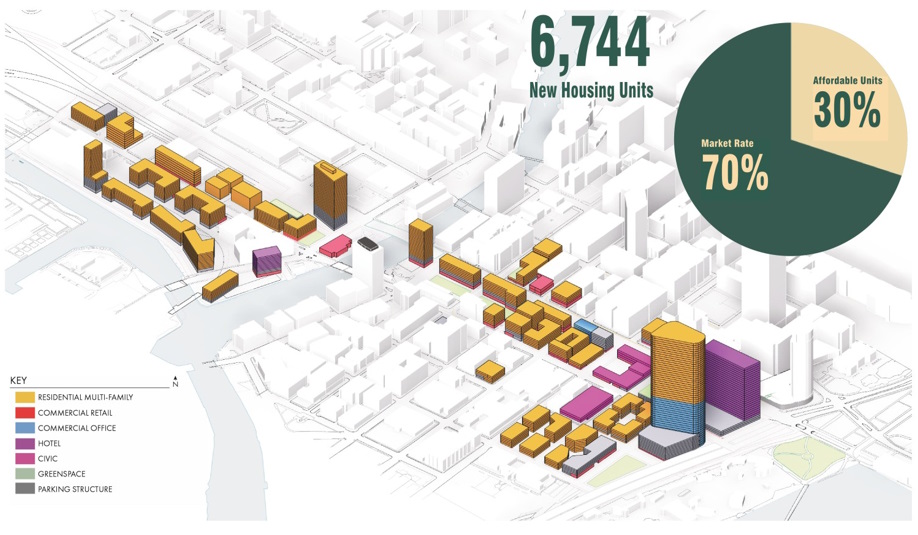
Mastodon master plan for Interstate 794 replacement.
“If 794 comes down, what’s possible?”
That was the challenge posed to 14 UW-Milwaukee students in a UW-Milwaukee School of Architecture and Urban Planning seminar by professors Carolyn Esswein and Larry Witzling.
The Wisconsin Department of Transportation (WisDOT) has been studying replacing the east-west, elevated portion of Interstate 794 between the Marquette Interchange and the Hoan Bridge for more than a year and is considering options that include a boulevard or a substantially slimmed-down elevated freeway.
Split into teams of seven, the students in the semester-long seminar created two master plan concepts for what a freeway-to-boulevard conversion could look like. They presented their work Thursday at The Avenue.
“With planners, we’re looking at street design, enhancing Clybourn to handle lots of cars, while St. Paul is a little bit more a walkable, commercial street, bike lanes, parks, plazas. And the architecture students focused more on the massing [of future developments]… envisioning the types of housing and the scale,” said Esswein, the department co-chair.
Students broke the master plans into districts, tackling ideas like expanding the Milwaukee Public Market into a larger area or redeveloping the U.S. Postal Service’s central post office. Other options considered included how to route bus routes through the area or how to preserve the identity of the Historic Third Ward when a freeway no longer divides it from Downtown.
“When the highway comes down, the adjacent parcels that are available have a different value,” said Esswein. One of the master plans envisioned $4 billion in new development within 30 years, which would generate $100 million in new annual property tax revenue. Esswein said the group was then tasked with thinking about how that would be spent throughout the city.
“What excites me a lot is the housing,” said graduate architecture student Gabe Zaun who worked on a high-density lakefront area and helped run mathematical models for the larger master plan. Zaun said he put substantial time into calculating what amount of parking would be required, especially to accommodate more than 7,000 new housing units and the existing festival traffic.
He saw his opinion of the project change as he worked on the project. “I didn’t know much about it,” said Zaun of his opinion before the project started. Now he’s in the “it should come down” camp.
Isabelle Jardas, a graduate architecture student, helped create a subdistrict called “Hoan Landing” where the Hoan Bridge comes down to ground at its northern end. “What we want to do is pull the energy from Summerfest out,” said Jardas of the mixed-use district with housing, restaurants, possible music venues and other entertainment options. “We kind of see this as a good opportunity for the Third Ward to have some of that.” It would also contain a street grid capable of distributing the traffic from festivals and the bridge.
Jardas said one of the challenges she encountered was balancing the large lots that would be created with the need to shape buildings in a way that would provide natural lighting and create public plazas that open up to the street.
“I’m more leaning towards taking it down. I’m glad we got to explore some of the impact to the city if we did take it down,” said Jardas.
The students did not formally interface with WisDOT on the project, but their designs were based on the freeway-to-boulevard street grid options previously released by the department.
The two plans are known as Mastodon, a nod to the sculpture installed in 2023 on a remnant freeway parcel along W. St. Paul Avenue, and The Stitch, for reconnecting the area.
While the UWM project is at its end, WisDOT continues to pursue the project. In early April, Urban Milwaukee reported on the remaining design alternatives that are being studied. Community meetings are expected to be held later this year to allow the public to weigh in on the proposed designs.
UW-Milwaukee has a lengthy history of exploring big picture design concepts with graduate and undergraduate students. Much of the conceptual vision for the Park East Freeway’s removal was advanced by a design studio at the university. Students have also looked at several other areas, including the Marcus Performing Arts Center parking structure site.
Mastodon Boards


The Stitch Boards


2025 WisDOT Design Alternatives


If you think stories like this are important, become a member of Urban Milwaukee and help support real, independent journalism. Plus you get some cool added benefits.
More about the Interstate 794 Rebuild
- Murphy’s Law: Mayor’s I-794 Stance Betrays His Grow Milwaukee Goal - Bruce Murphy - Jul 22nd, 2026
- Opposing Mayor, Council Members Back Boulevard to Replace I-794 - Jeramey Jannene - Jul 13th, 2026
- I-794 Highway-to-Boulevard Option is Best for City of Milwaukee - Ald. Bob Bauman - Jul 13th, 2026
- MMAC Supports Mayor’s Recommendation for I-794 Lake Interchange Project - Metropolitan Milwaukee Association of Commerce - Jul 8th, 2026
- Mayor Opposes Replacing I-794 Connection With Downtown Boulevard - Jeramey Jannene and Sophie Bolich - Jul 8th, 2026
- See Costs, New Details For 794 Replacement Options - Jeramey Jannene - May 1st, 2026
- State To Reveal New I-794 Cost Estimates - Jeramey Jannene - Apr 7th, 2026
- 794 Teardown Advocates To Host Walking Tour - Jeramey Jannene - Mar 30th, 2026
- Real Estate Group Casts Doubt on I-794 Removal Plan - Jeramey Jannene - Nov 11th, 2025
- See How State Thinks Traffic Would Change With I-794 Removal - Jeramey Jannene - Nov 5th, 2025
Read more about Interstate 794 Rebuild here


I always like seeing the project work of the UWM students and my personal hope is that the freeway comes down and Milwaukee can optimize the value of this exceedingly underutilized land.
Two things:
~ Jeramey, thank you so much for sharing all of the project boards…I will be spending at least a couple hours going through them this weekend. The problem is that the image sharing widget, at least for paid members, doesn’t readily accommodate images with a hyper portrait orientation that are also so content rich, and likely created to be shared on boards that are at least 2’x4’. (I read most everything on an iPad so I can enlarge words and images easily at whim. The best workaround for me was to go to my laptop, right-click and image, and copy it to a new tab, which allowed me to zoom in once.) is there something Urban Milwaukee can do on its end?
~ Second, one of the boards, I believe from the Mastadon group, scopes out a 30-year period for redeveloping all the newly available land, a bit humorously after another board claims developers will “flock” to the property, or some such thing. While the image of flocking and the projection of a 30-year period seem a bit incongruous to me, I do get that it will take longer than I would want. (Hey, it’s been 23 years since the Park East freeway was replaced with McKinley Boulevard and there are still 2-3 plots that remain to be developed in the nine-block stretch between 6th Street and Milwaukee Street. Part of my desire to speed up the process is totally driven by self-interest—I will be 92yo if I make it 30 more years and would love to see the results. In addition, for the city and the entire region to benefit from the new development and tax revenue ASAP, I wonder if there is a way for officials to fast track projects. Architecture students are used to doing charettes for their projects. Perhaps officials, the public, and developers can begin to come together in a sort of charette process, once a decision on the fate of the freeway is made but before removal work is completed, to consider highest and best uses for the land and sell sites to developers who will be ready to move in short order.
In the end, all exciting stuff!