
See Design Concepts for 30th Street Corridor Trail
New trail could connect north side neighborhoods to larger network of trails in Milwaukee County.
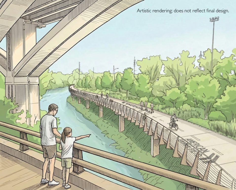
Conceptual artwork for one of the 30th Street Corridor trail idea called “Greenway Link.”
The Milwaukee County Department of Transportation (MCDOT) recently released general concepts for a proposed multi-use trail running through Milwaukee’s 30th Street Industrial Corridor alongside an existing rail line.
MCDOT and consultants from SmithGroup are in the middle of a feasibility study considering ways to develop a trail running from Havenwoods State Park south to the Hank Aaron State Trail. The approximately seven-mile corridor would create trail connections between north side neighborhoods and the wider trail network in Milwaukee County, including the parks system’s more than 135-mile Oak Leaf Trail.
The new trail, depending on the final design, could include new safety infrastructure, elevated trails and new trail boardwalks along water features and through natural areas.
“Bicycle and pedestrian trails are an important part of our transportation network, especially in Milwaukee County where we are working toward transportation solutions for a large non-driving population,” said Joe Lamers, MCDOT director, in a statement. “Expanding transportation options that work for all of our residents can help create a safer, healthier, more connected community.”
The three trail concepts consider potential routes as well as the infrastructure that might be included. County and city officials have long eyed the grade-separated Wisconsin and Southern Railroad (WSOR) rail corridor for a trail, and two concepts envision running the trail alongside the railroad at various points.
A concept called “Corridor Direct” would largely follow the rail line running through McGovern Park south to the Hank Aaron Trail entrance east of American Family Field. Portions of the route would run on elevated trails next to or over the railroad.
“Most of the 30th Street Corridor railroad right-of-way is private property, and the owners have not granted permission for public use, including the proposed trail,” according to MCDOT. “If permission were granted in the future, this route would provide the most continuous, uninterrupted trail option.”
The City of Milwaukee has attempted to purchase the railroad corridor and lease it back to WSOR to continue operating, but has been rebuffed.
Another idea called “Greenway Link” strays further from the rail line through Custer Playfield and cuts a wider berth through a planned naturalized stormwater basin and through Century City. The goal is to maximize exposure to green areas along the trail. It would use city rights of way to build out on-street trail.
The third concept, called “Explore the Neighborhoods,” zig-zags through Old North Milwaukee, Garden Homes, Amani and Midtown primarily using city streets. It would be the most accessible route, and it would include new road safety infrastructure to make the route safer for biking. “However, this route includes the most at-grade street crossings, and the addition of a separated trail along existing streets may cause conflicts with neighboring homes and businesses,” according to MCDOT.
MCDOT is looking for public feedback on the trail concepts, which will be used to select a preferred plan. A survey is available on the project webpage.
The feasibility study will be finished in 2027. It was funded through a $700,000 Transportation Alternatives Program (TAP) grant from the federal government. Future detailed design and construction will depend on additional funding and cooperation of the railroad.
The 30th Street Corridor was identified in Milwaukee County Parks‘ Northwest Side Trail Plan as a priority trail corridor. The north side of the county and the city of Milwaukee is a trail desert, with many areas lacking a direct connection to the county’s extensive trail network.
“Creating safe, accessible, bicycle and pedestrian access along the 30th Street Corridor would be one of the most impactful trail projects in the Milwaukee County region,” said Willie Karidis, Rails to Trails Conservancy’s Route of the Badger Project Director, in a statement from MCDOT. “Completing this study is another step toward significantly increasing equitable trail access to grocery stores, schools, employment, and nature.”
Railroad Company Statement
After publishing, Ken Lucht, Vice President of Watco, which owns a majority of the Wisconsin & Southern Railroad, told Urban Milwaukee, “The county has reached out to us, informing us of their planning process but we are not a stakeholder in their process and we are not participating. The city has a myriad of existing public roadways, trails and other public ways they can use for a future trail. The rail corridor is not for sale, lease or permit to the public.”
Conceptual Renderings


2020 Study Images


Existing members must be signed in to see the interactive map. Sign in.
If you think stories like this are important, become a member of Urban Milwaukee and help support real, independent journalism. Plus you get some cool added benefits.
More about the 30th Street Corridor Trail
- Transportation: See Design Concepts for 30th Street Corridor Trail - Graham Kilmer - Apr 30th, 2026
- MKE County: County Holding Public Meeting on 30th Street Rail-Trail - Graham Kilmer - Feb 12th, 2026
- Transportation: 30th Street Corridor Trail Study Begins in May - Graham Kilmer - May 1st, 2025
- Milwaukee Wants To Buy 30th Street Line, Railroad Says No - Jeramey Jannene - Mar 18th, 2025
- Federal Grant Boosts Trail Connectivity Within Milwaukee’s 30th Street Corridor: A Model for Collaborative Community Development - Near West Side Partners, Inc. - Jan 13th, 2025
- Consultant Sought To Design 30th Street Corridor Trail - Jeramey Jannene - Jan 3rd, 2025
- Trail Extension Will Link Downtown With Planned 20th Street Trail - Jeramey Jannene - Dec 5th, 2024
- MKE County: Parks Finishes Trails Plan for Northwest Side - Graham Kilmer - Apr 5th, 2023
- Transportation: Should City Buy 30th Street Railroad Line? - Jeramey Jannene - Nov 10th, 2021
- Transportation: Study Released For 6.7-Mile 30th Street Trail - Jeramey Jannene - Jan 27th, 2021
Read more about 30th Street Corridor Trail here
Transportation
-
See Costs, New Details For 794 Replacement Options
 May 1st, 2026 by Jeramey Jannene
-
Why Milwaukee’s Potholes Are So Bad, And What’s Changing
 Apr 28th, 2026 by Jeramey Jannene
-
Airport Launches Sign Language Service
 Apr 28th, 2026 by Graham Kilmer


Why can’t we use eminent domain to take the land?
There’s a lot of this plan that’s viable, but the viaduct over the yards isn’t. It doesn’t even look all that pleasant as it’s too narrow. It would also be incredibly expensive.
@PantherU in Wisconsin you can’t use eminent domain to build trails: https://wisconsinbikefed.org/what-we-do/advocacy/legislative-agenda/eminent-domain/
@puegeot thank you for the answer!
Heat is going to drive agricultural, manufacturing and service businesses northward, along with their workers and customers and equipment. The cities having the best and most flexible. freight and rapid transit rail capacities will grow and thrive, and more dramatically than those that don’t. We need to export and diversify our economy to bring in outside money,
Notes on the modern economy are best written in pencil.
This corridor can connect and generate both freight and passenger traffic, especially if the passenger traffic is elevated and features transfer engagement with bus lines.
As much as I like trails, they could diminish the capabilities of one or both of these vital rail services In short, rail use, both passenger transit & freight, provides the most valuable overall benefits to Milwaukee.
Current owners’ reluctance to sell is understandable.
They don’t want to be excluded or unreasonably impeded
by a government throwing its weight around.
Milwaukee County is a more viable partner than the City, since it has staff and facilities for, and experience in running the bus transit system that rail transit would interface with.
Expect to hire some out-of-town expertise.
The city of Milwaukee is unlikely to have even vestiges of knowledge and experience to run it, except for possible archived evaluations.
The Hop is not relevant – being stuck in pavement, it is vulnerable to all the conditions and events that slow or stop traffic on pavement. It can provide additional, larger-sized adventures
if mechanical or electrical failure occurs.
Let’s not expand our “portfolio” of squandered rapid transit rail rights-of-way, begun in 1962
It would be great to have Milwaukee County talking to trail users about their experiences in addition to trail expansion. There are some very dangerous crossings where a flashing yellow light is needed to help improve rider safety. How about starting to talk about there e-bikes that are like mini motorcycles and are operated by some who carry little about the safety other rides. Are there sections of trail that are used heavily by bikers and walkers that could be widened? Should there be some speed restrictions for the 25 mph road bikers who sometimes are slaloming through walkers and slower bikers on weekends when the trails are heavily used? Milwaukee County should send up some staff to talk to trail users about their concerns.