Public Meeting On Freeway-To-Boulevard Project
Community input sought on proposal to convert Stadium Freeway to boulevard.
The Wisconsin Department of Transportation (WisDOT) wants your input on the study to convert the Stadium Freeway spur into a boulevard on Milwaukee’s West Side.
A public involvement meeting is being hosted on Tuesday, April 30. It’s the first meeting being held since the department created alternative design options. The meeting will be held from 4 p.m. to 7 p.m. at the Washington Park Senior Center, 4420 W. Vliet St.
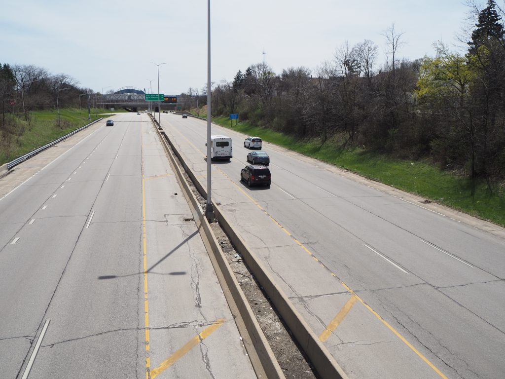
First announced in May 2022, the study seeks to generate a shared vision for the future of Wisconsin Highway 175 from W. Wisconsin Avenue 1.5 miles north to its terminus at W. Lisbon Avenue.
The six-lane roadway separates the Washington Heights neighborhood on the west from the Washington Park neighborhood to the east. It terminates just south of W. North Ave. in the Uptown neighborhood. The spur, which runs north from the Stadium Interchange, originally opened in 1962. It was planned as part of a largely-unbuilt network of freeway loops that would encircle Milwaukee.
In 2022, both Mayor Cavalier Johnson and County Executive David Crowley endorsed major changes to the roadway. “Now is the time to correct the flawed infrastructure of our predecessors,” said Johnson at a press conference. “The time for change is always now,” said Crowley.
WisDOT is funding the effort, estimated to cost up to $3 million. “We are really excited that we are at the point where we can look and imagine what 175 can look like,” said WisDOT Secretary Craig Thompson at the 2022 press conference.
The first public engagement meeting was held in May 2023. A third meeting, according to a project schedule, is to be held in the fall. The study is to be completed by the end of 2024.
The current configuration offers only five opportunities to cross the freeway between W. Wisconsin Ave. and W. Lisbon Ave. Similar to the Park East reconfiguration, converting it to a boulevard could allow better integration into the street grid, reducing travel times for many trips.
Urban Milwaukee, as part of its Intersections column, published an opinion piece by John O’Neill in 2016 exploring options for replacing the freeway with a boulevard and reconfiguring the northern on-off ramps. The city studied conceptual redevelopment options for the same stretch in 2017. It also purchased the 51,220-square-foot lot between the north-south ramps at the end of the freeway for $270,000. Johnson said it would give the city more control and flexibility in reconfiguring the freeway.
A reconfiguration could also open up more access to Wick Playfield, Doyne Park and Washington Park, each of which directly borders the freeway. Crowley noted that some people need to go a half-mile out of their way to access the parks today.
North of Wisconsin Avenue, the spur sees 71,000 vehicles per day according to 2022 WisDOT data. The traffic volume falls to 57,300 vehicles per day north of W. Vliet St. The parallel Interstate 41 and Interstate 43 corridors each see in excess of 150,000 vehicles per day.
Existing members must be signed in to see the interactive map. Sign in.
If you think stories like this are important, become a member of Urban Milwaukee and help support real, independent journalism. Plus you get some cool added benefits.
More about the Highway 175 Redesign
- Transportation: Public Favors Stadium Freeway Removal - Graham Kilmer - Jan 22nd, 2026
- A Final Public Meeting On Converting Stadium Freeway to Boulevard - Jeramey Jannene - Apr 1st, 2025
- Transportation: WisDOT Releasing New Freeway-to-Boulevard Designs in April - Graham Kilmer - Jan 22nd, 2025
- See The Design Concepts To Replace Stadium Freeway - Jeramey Jannene - May 1st, 2024
- Public Meeting On Freeway-To-Boulevard Project - Jeramey Jannene - Apr 26th, 2024
- Transportation: West Side Freeway-to-Boulevard Study Advances - Jeramey Jannene - Mar 27th, 2023
- Wisconsin Loses Out on Stadium Freeway Grant - Jeramey Jannene - Mar 1st, 2023
- Transportation: Should Milwaukee Remove A Second Freeway? - Jeramey Jannene - May 4th, 2022
- Supervisor Burgelis Encourages Public Participation in Highway 175 Study - Sup. Peter Burgelis - May 4th, 2022
- City Hall: Vliet Street Reconstruction Gets Federal Funding - Jeramey Jannene - Apr 27th, 2022
Read more about Highway 175 Redesign here
Political Contributions Tracker
Displaying political contributions between people mentioned in this story. Learn more.
- August 13, 2015 - Cavalier Johnson received $25 from David Crowley
Transportation
-
Congestion Pricing Cuts Air Pollution in New York City
 Dec 14th, 2025 by Jeff Wood
-
FTA Tells Milwaukee to Crack Down on Fare Evasion — Even Where Fares Don’t Exist
 Dec 12th, 2025 by Graham Kilmer
-
Will GOGO’s Bus Service Ever Get Going?
 Dec 9th, 2025 by Jeramey Jannene












Yes Artfully done makes lots of sense. There is no Harbor on one end of the freeway segment. It is not to late to wake up Maybe Urban Milwaukee could do some survey about the truck traffic and its impact That would be useful. Sort of like the ParkWest Freeway folks who opposed the freeway segment along North Avenue documented how a 10 or was it 12 lane freeway was a folly
Give the harbor folks a voice
I’m curious to see what designs they propose. The topography on some parts of this route don’t seem to suggest a boulevard that’s integrated with the street system. Maybe through Washington Park this could be done, but having a high traffic road in the park at street level doesn’t suggest to me a place for a pleasant stroll.
Now THIS one makes sense! Yes, please.
> The topography on some parts of this route don’t seem to suggest a boulevard that’s integrated with the street system.
That’s the sad part… look at the aerial photos (county GIS site has them) from 1951. Where the freeway is now was level and completely integrated with both Washington Park and the surrounding neighborhoods (talking about the areas north of Martin Dr here). The topography there now is completely man-made by demolishing the neighborhoods.
What is the traffic count on the spur now? yes the topography is an issue Add some land to Washington Park?? Keep the bridges over State and the river A narrower road way??
Average Annual Daily Traffic counts on STH 175 are as follows as measured in 2022:
North of Washington Blvd: 31,700
Between Vliet St and Washington Blvd: 57,300
Between Wells St and State St: 71,000
Bewteen Stadium interchange and Wisconsin Ave: 72,800
Thanks for the traffic information Also with Interstates 41 and 43 both under construction it would be good to leave this alone Then relook at the numbers As someone pointed out the topography and the existing land uses are the controlling features. It does provides a connection for 57,000 westside and near northwest sides folks to connect to the freeway system or to go south of the freeway While there is no harbor on Baseball days what is the additional usage??
@Thomas – The traffic counts include vehicles in both directions.
The topography, with the recessed highway, is largely man made. The design concepts released Tuesday, https://urbanmilwaukee.com/2024/05/01/see-the-design-concepts-to-replace-stadium-freeway/, would level much of it back to how it was.