
Group Unveils Plans To Replace 794 With Boulevard
Rethink 794 thinks replacing elevated freeway with boulevard could lead to $1.5 billion in development, better city.
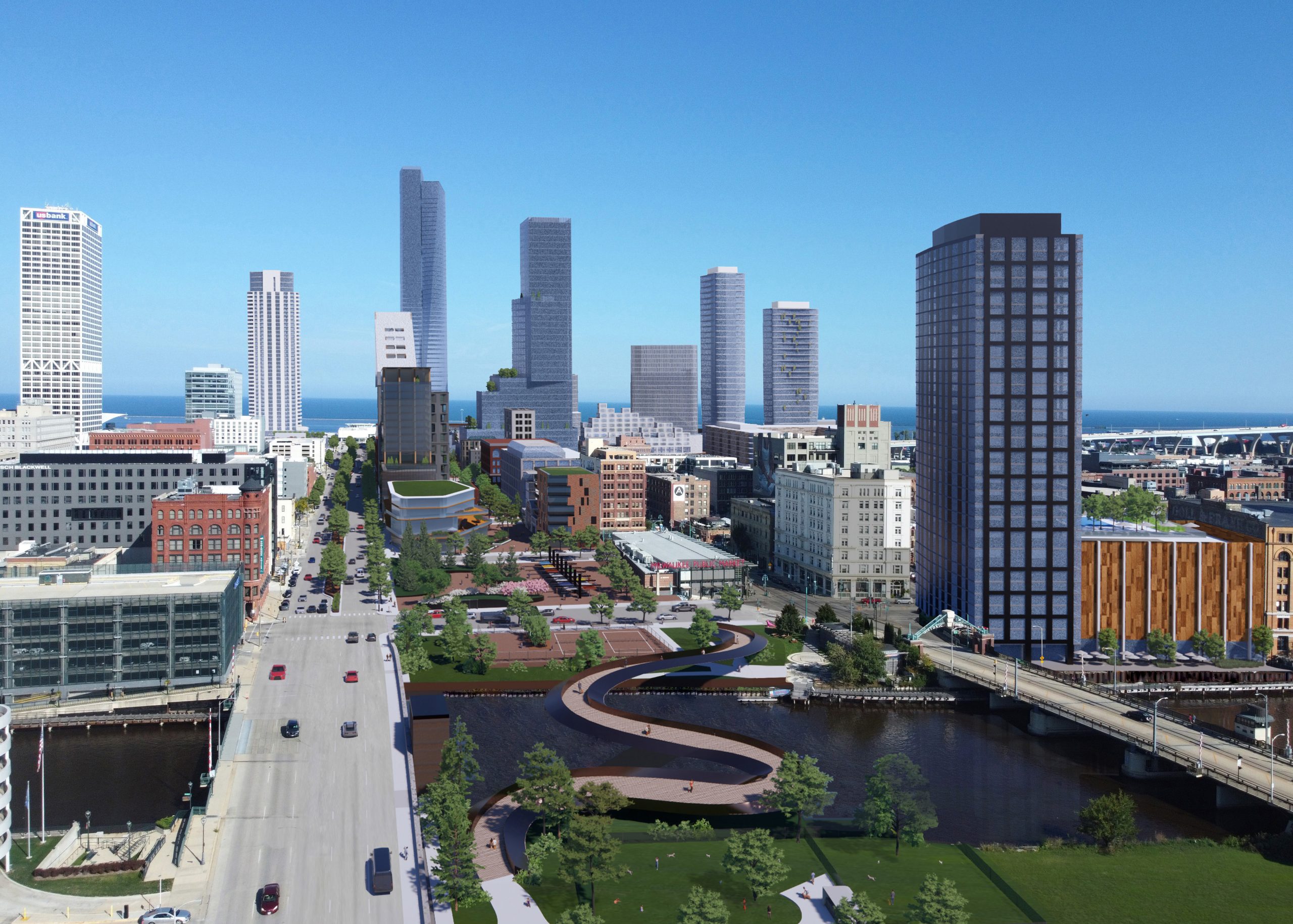
Interstate 794 replaced by a boulevard. Rendering by Taylor Korslin/Rethink 794
A new coalition, known as Rethink 794, has a vision to see Interstate 794 in downtown Milwaukee replaced with a boulevard. It’s a proposal the group thinks could save money, grow Milwaukee and better connect the city.
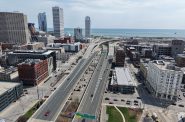
Their proposal, which they’re asking the Wisconsin Department of Transportation (WisDOT) to study, would keep the Hoan Bridge. But the east-west elevated freeway between N. Lincoln Memorial Dr. and N. 6th St. would be replaced with a street-level boulevard.
The coalition released renderings Monday of what the reconfigured street could look like, with the Historic Third Ward reconnected to Downtown. It will host a webinar Wednesday, Oct. 19 at noon to further discuss its idea and call for a formal study.“Is the best possible use of the space an elevated freeway? This is the most valuable real estate in all of Wisconsin,” said 1000 Friends of Wisconsin transportation policy analyst Gregg May, a leader of the coalition, in an interview.
WisDOT has an active project that includes considering options on how to reconstruct the freeway east of the Milwaukee River before rebuilding it in 2025. May and others want the state agency to formally examine the potential for replacing the elevated freeway, built in 1974, with an at-grade boulevard. WisDOT’s proposal to rebuild the highway as an elevated structure would cost $300 million, but the Rethink coalition believes its proposal could cost much less and generate value for the city and state in the future.
“From a math standpoint, it’s a no-brainer,” said Ben Crowther, advocacy manager for national nonprofit America Walks.
At its core the coalition’s vision is simple: free up land consumed by an oversized freeway for development or other purposes, while also better connecting the core of the city at street level. Based on conceptual estimates, the group believes the underlying 32 acres could see $1.5 billion in new development and generate $15 million annually in new property tax revenue.
The group believes that traffic data suggests the highway is a good candidate for conversion to a street-level boulevard. “[Traffic counts] are telling us that people are using the Hoan Bridge and Marquette Interchange to access downtown, not travel through it,” said May. “A boulevard is a better way to disperse people through a grid system.”
That’s part of the same reasoning that led to the removal of the Park East Freeway spur on the north side of Downtown almost two decades ago. Travel times decreased for a number of trips because of the increased turning options provided by a grid versus freeway ramps.
“Our effort isn’t to eliminate the Hoan Bridge or that connection that is vital to a lot of the southern portion of the city,” said architect Taylor Korslin. The group, formed by May, came together in January and has worked to refine and build support for the idea.
Korslin and landscape architect Xu Zhang produced aerial renderings to demonstrate the highway’s impact, and how making Clybourn Street into a grand boulevard could function.
“These are just an effort to show an alternative, to give people an inspiration,” said Korslin. His renderings show new high-rise buildings near the lakefront, including the under-construction The Couture tower, and smaller-scale development near the Milwaukee River.
“By no means are we trying to push for high density with lots of skyscrapers,” said Korslin. He said a number of different development styles should be considered, along with public uses like parks or an expanded Milwaukee Public Market.“We are trying to focus on what value can be added,” said Zhang.
Her street-level rendering depicts how new buildings would fill what is primarily a row of parking lots that border the freeway today. Zhang said the environment she’s depicting, a walkable, urban place, is the exact environment many big employers are looking for today.
“I think the Huron Building chose their location not because of the highway, but because of the Third Ward,” she said of the new office building located just north of the freeway.
But while the vision is simple, there are plenty of things a formal study would need to explore.
The group is already considering options for what to do with certain use cases, like truck traffic to and from the port of Milwaukee. One option they’ve considered is improving the connectivity at the southern edge of the port via W. Becher St. to Interstate 43/94. Korslin said it would be a shorter route than what trucks take today through downtown.
Rehtink 794 also would be open to options for different boulevard lengths. Their proposal would have the freeway end near the site of the proposed Iron District development near the Marquette Interchange.
The group would like the proposal to be included in the City of Milwaukee’s Downtown Plan update. The city is in the middle of what it calls “Connec+ing MKE 2040,” an update to its 2010 plan.“The most useful tool for getting the Park East [Freeway] removed was having a study in the downtown plan,” said May. The 1999 plan identified it as a catalytic project. In 1995, UW-Milwaukee students studied boulevard replacements for both 794 and the Park East spurs. More political will emerged behind the latter at the time.
The Metropolitan Milwaukee Association of Commerce has endorsed WisDOT studying a boulevard option for 794. “We’re a big tent group,” said May.
Crowther, who supports approximately 40 highway conversion or teardown groups across the country, said the Milwaukee proposal is among the best for economic potential. “This really is prime real estate,” said Crowther. It’s also a more straightforward case for removal. “It’s not an integral part of the interstate system.”
“This kind of highway removal project is very challenging, but it’s happening all over the nation,” he said.
May noted that the state has already committed to studying replacing the Wisconsin Highway 175 freeway spur with a boulevard, and 794 carries a similar amount of traffic. WisDOT reports 67,700 vehicles cross the river daily on 794 and 67,400 vehicles traverse 175 north of W. Wisconsin Ave.
Rethink 794 will present its vision in a free webinar Wednesday, Oct 19 at noon. The coalition also has a website with more information.
Renderings


If you think stories like this are important, become a member of Urban Milwaukee and help support real, independent journalism. Plus you get some cool added benefits.
More about the Interstate 794 Rebuild
- Murphy’s Law: Mayor’s I-794 Stance Betrays His Grow Milwaukee Goal - Bruce Murphy - Jul 22nd, 2026
- Opposing Mayor, Council Members Back Boulevard to Replace I-794 - Jeramey Jannene - Jul 13th, 2026
- I-794 Highway-to-Boulevard Option is Best for City of Milwaukee - Ald. Bob Bauman - Jul 13th, 2026
- MMAC Supports Mayor’s Recommendation for I-794 Lake Interchange Project - Metropolitan Milwaukee Association of Commerce - Jul 8th, 2026
- Mayor Opposes Replacing I-794 Connection With Downtown Boulevard - Jeramey Jannene and Sophie Bolich - Jul 8th, 2026
- See Costs, New Details For 794 Replacement Options - Jeramey Jannene - May 1st, 2026
- State To Reveal New I-794 Cost Estimates - Jeramey Jannene - Apr 7th, 2026
- 794 Teardown Advocates To Host Walking Tour - Jeramey Jannene - Mar 30th, 2026
- Real Estate Group Casts Doubt on I-794 Removal Plan - Jeramey Jannene - Nov 11th, 2025
- See How State Thinks Traffic Would Change With I-794 Removal - Jeramey Jannene - Nov 5th, 2025
Read more about Interstate 794 Rebuild here
Transportation
-
Milwaukee Plans 60 Traffic Safety Projects for 2026
 Apr 8th, 2026 by Jeramey Jannene
-
State To Reveal New I-794 Cost Estimates
 Apr 7th, 2026 by Jeramey Jannene
-
Bus Riders Can Finally Pay With Credit Card
 Apr 6th, 2026 by Graham Kilmer


That curving thing (pedestrian path?) crossing the river is unrealistic because (under federal law), you can’t obstruct river traffic. That’s why every bridge over the River (except 794 and the skywalks) opens. As I remember, 794 was constructed high enough to allow any likely ship to pass underneath. I think the 2 skyways were constructed at the same (or greater) height.
Happy Monday! What a great way to start the week…
As a longtime downtown Milwaukee enthusiast closing in on 60yo, I feel bittersweet about this. I give myself 25 more Christmases until I meet my Maker and its been nearly 20 years since the Park East freeway was demolished. Twenty years to get to where it is today. What’s the Greek proverb? “A society grows great when old men plant trees in whose shade they know they shall never sit.”
This certainly fits the “make no small plans bill.” Love it! I have the feeling the tide may actually be turning in this direction. These kinds of things seem to happen over generations. Values and perspectives change.
Of course I agree with TransitRider. The bridge will never happen, wonderful concept though it is. Good enough to get some more open space… Twenty years ago we could have not imagined where we are now with downtown–both opportunities and challenges. As a reality check given where we are now, I say expect most if not all high rises to be residential and expect 2-3 tops instead of the seven pictured in the renderings. Indeed, filling 32+ acres of vacant land downtown in addition to projects on other downtown areas will require lots of housing.
Oh, and I like the map the Business Journal published to accompany this news–knock down 794 all the way west to 6th Street!
I would love to see an expansion of the highly-successful Milwaukee Public Market toward its north. On the west bank of the Milwaukee River, north of St Paul Avenue, could be a Milwaukee River Market, with riverside balcony restaurants and mixed use housing and offices above. Tear down this wall (of the freeway spur), but make use of the land freed up, don’t just leave it empty space. This is the heart of a very highly successful area because of the unique density and interest it has managed to generate despite this freeway spur stuck in its midst. It would be terrible to approach it with suburban eyes and seek low density and empty space. Have medium but also some tall buildings, mixed uses, including pocket parks, and more aspects of the city to enjoy. The most green city is the most dense and makes the most use of its land so as not to put pressure on additional sprawl at its edges and allows people to live close to their regular destinations. Successful cities create a distinct option of urban density, in sharp contrast to suburban low-density, and this is an opportunity to grow urbanism in that direction.
The MU interchange rebuild project (circa 2008) included rebuilding 794 as far east as (approximately) Milwaukee/Jefferson, including the river crossings.
Through that area, the freeway is two independent structures (one for eastbound lanes, one for westbound lanes). The project was done by temporarily rerouting all traffic to one structure, demolishing the other one, rebuilding the demolished section, then repeating the process for the other structure.
This meant that for a long period, the freeway’s “presence” was reduced by half. I recall reading comments in the press that this positively affected the neighborhood (more sunlight, better views, etc.). But by then, the work was “full speed ahead” and way beyond the point of considering alternatives.
The challenges to designing an alternative are huge, most notably the river crossing. As another writer noted, with ever increasing boat traffic, this is not an ideal place for another movable span bridge.
A key point is determining how exactly people use that segment of 794. When the Park East removal was debated, there was no shortage of people who thought no alternatives would work. As we now know, the alternatives serve that neighborhood better than the elevated freeway.
Jeramey can you make the photos on UM website capable of being enlarged?
@wardt01 – They are already capable of being enlarged. If you’re on a photo, you should be able to pinch the image after clicking on it. If you’re on a desktop computer you can zoom in your browser (often with a mousewheel + control) or right-click to view in its own window. Let me know if you’re having issues getting that to work.
John December, if the Public Market expanded north into the space now occupied by I-794, it could have an entrance on Clybourn which would make it seem much closer to the office buildings on Wisconsin Avenue. Removing the “wall” created by 794 would also make the Market seem closer.
No one proposing this is likely a user of this segment. People on the East Side, Bay View, and the South Shore actually use this segment to get places. The sections that were replaced recently are less of a wall than the original structures. Freeways are ugly but people like to get places. This same logic would argue that we should make I-43 a boulevard through Downtown to increase development near Marquette.