How Is City Doing on Complete Streets?
New report analyzes ongoing program, establishes benchmarks for future progress.
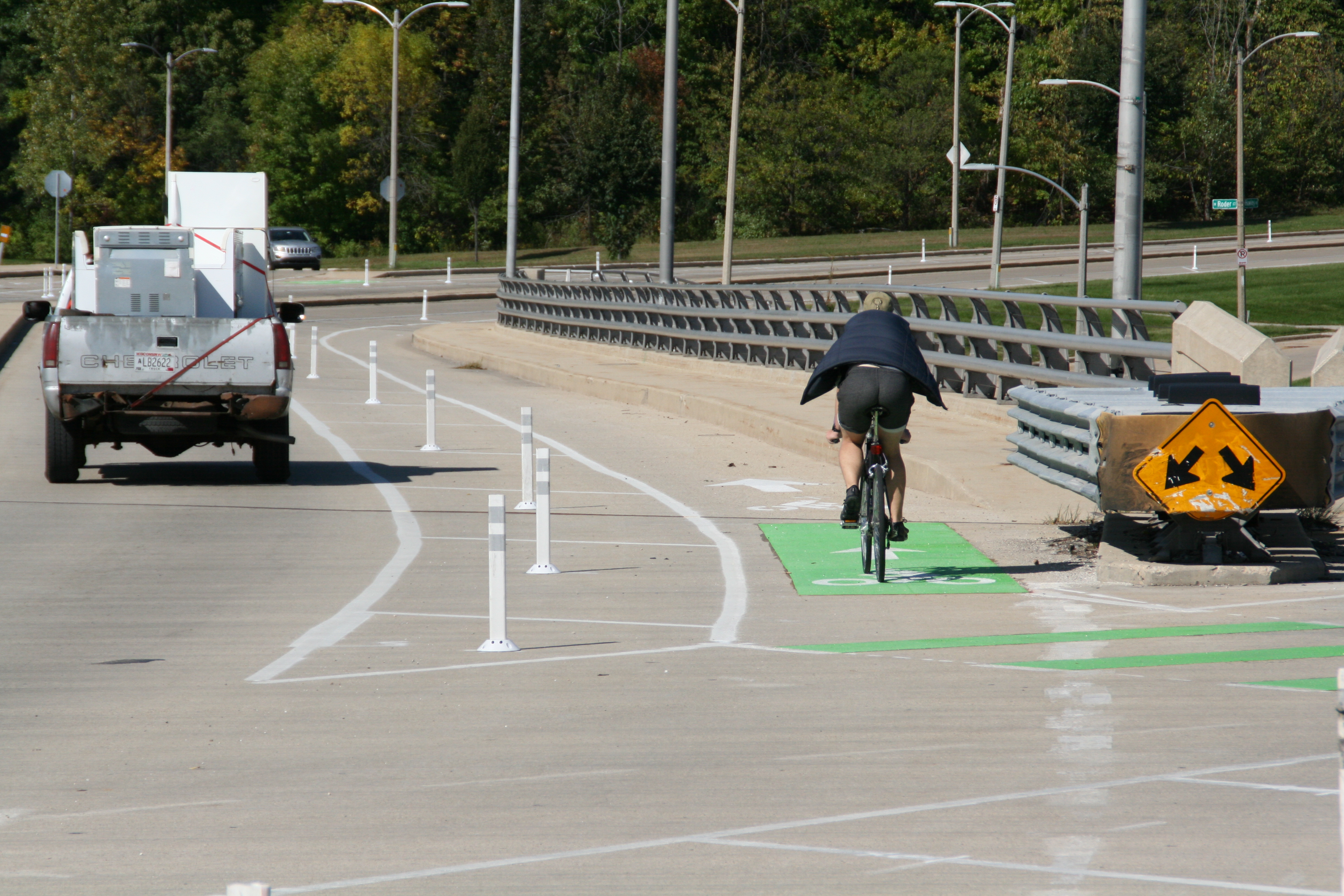
A cyclist on the N. Hawley Rd. protected lane. Photo by Jeramey Jannene.
The Department of Public Works (DPW) has unveiled its first benchmark report on how the city is doing in its effort to increase safety for all street users.
Known as the Complete Streets policy, it requires DPW and other city departments to take into account not just motorists, but the safety of pedestrians, bicyclists and other road users, regardless of age or ability, in every street project.
In the analysis, the city does not attempt to give itself a grade, but instead creates benchmarks for future progress. The report, released in August 2020, covers projects completed in 2019. The policy was adopted in October 2018.

Equality versus Equity. Image from the City of Milwaukee.
“This allows us to gauge our success and look for areas of improvement as we work to ensure Milwaukee’s streets and public spaces properly serve every resident, regardless of their background or how they choose to move around our city,” said Public Works Commissioner Jeff Polenske.
An equity lens is applied to the analysis, with a graphic for bicyclists emphasizing the difference between equity and equality. “Equity goes beyond simply treating everyone the same. Equity means that individuals and groups receive treatment or resources based on their individual needs or assets, or because they have been treated differently historically,” says the report.
“Meaningful changes and successful implementation of the Complete Streets policy will only be realized if people and neighborhoods that have historically faced disinvestment and currently experience many negative health outcomes benefit most. All Milwaukeeans must experience the health, social, economic, and safety benefits that Complete Streets provide,” says the report in its conclusion.
The city uses the federal US Department of Housing and Urban Development (HUD) designation of Neighborhood Revitalization Strategy Areas (NRSA) to determine which areas of the city to specifically monitor investment and overall progress. HUD requires the areas to be made from contiguous census tracts where a majority of the population earns 80 percent or less of the county median income.

Milwaukee NRSA map. Image from the City of Milwaukee.
In Milwaukee, the HUD NRSA designation applies to 61.2 percent of the city’s population and stretches from approximately W. Mill Rd. on the north to W. Oklahoma Ave. on the south and runs between Interstate 43 on the east and 60th Street on the west.
The report looks at all street reconstruction, repaving or striping projects greater than a quarter-mile in length where a “substantial design change” occurred. DPW notes that 22 projects were completed in 2019. Primarily due to the timing of the policy’s October 2018 adoption and long lead time on many DPW projects, only two projects incorporated Complete Streets improvements. One of the projects was located in an NRSA.
The city added 1.2 miles of protected bike lanes in 2019, slightly more than doubling the existing segments. A total of 3.5 miles of traditional bike lanes were added to the city’s existing 160 miles of marked or protected lanes and shared-use trails. Only 10.3 miles of that network are included in a designated NRSA.
DPW reports that 3,577 street trees were planted in 2019 and 37 bioswales (constructed to help handle stormwater runoff) were installed.
Trail usage counts found that the Marsupial Bridge that spans the Milwaukee River between Riverwest and the Lower East Side was the busiest trail segment surveyed with 215,492 users. The Beerline Trail near W. Vienna Ave. was the least traveled, with 11,868 users.
The report also looks at Bublr Bikes usage (74,702 trips) and scooter usage (350,130 trips). “Dockless scooter ridership numbers demonstrate the demand for increased transportation options, particularly in areas not well-served by public transportation,” says the report.
The report also notes city-specific bus ridership (17,360,596 trips, 9.6 million in NRSAs), bike on bus usage (87,318 uses, 46,742 in NRSAs) and streetcar ridership (760,321 trips).
The city recorded 12 fatalities and 71 serious injuries for pedestrians, one fatality and 11 serious injuries for bicyclists and 41 fatalities and 245 serious injuries for motor vehicle drivers. The data, paired with information on high-speeding areas and the city-identified pedestrian high injury network, is intended to form a baseline for future improvements
The 55-page report uses the reconstruction of S. Chase Ave., substantially completed in 2019, as a case study of what can be improved from a process standpoint. The project was first funded in 2014 and does not include any explicit improvements for pedestrians and cyclists.
A case study of what went right is centered on the conversion of N. Hawley Rd. between W. Wells St. and W. Vliet St. from two driving lanes in each direction to one, with the addition of protected bike lanes. “DPW crews implemented the traffic safety improvements in August 2019 and the desired changes were realized almost immediately,” says the report. The case study says the number of people going over 40 miles per hour decreased by 45 percent, average and median speeds fell by two miles per hour and motor vehicle traffic volumes increased by two percent.
The report also cites other programming efforts designed to generate community engagement, including project pre-walks (four were held in 2019) and a survey about perceptions of safety while walking and biking (164 responses from 20 events).
A number of projects have already been implemented in 2020 that aren’t included in the report, including narrowing or removing travel lanes, shortening pedestrian crossing distances and implementing an Active Street program.
A full copy of the report can be found on Urban Milwaukee.
If you think stories like this are important, become a member of Urban Milwaukee and help support real, independent journalism. Plus you get some cool added benefits.
Transportation
-
Milwaukee Plans 60 Traffic Safety Projects for 2026
 Apr 8th, 2026 by Jeramey Jannene
-
State To Reveal New I-794 Cost Estimates
 Apr 7th, 2026 by Jeramey Jannene
-
Bus Riders Can Finally Pay With Credit Card
 Apr 6th, 2026 by Graham Kilmer