Does the Estabrook Dam Cause Flooding?
Supporters of removing dam say it would reduce flooding, but their data is suspect.
The impact on flooding is perhaps the second most frequently cited reason for supporting removal of the Estabrook Dam rather than repairing it. As noted in Part 2 of this series, flooding problems occurring in this area were in part responsible for a state law enacted in 1931 which included flood mitigation measures and led to public works projects completed during 1933-40 that included construction of the Estabrook Dam. Today, the neighborhoods bordering the north end of the Estabrook Dam impoundment still contain the largest number of homes subject to flooding of any area in Milwaukee County. Although the dam was constructed as part of a flood control project, removal of the dam would potentially reduce flood levels in the flood-prone area. The benefits from lowering the water level would include reduced occurrence of flood damage and elimination of flood insurance requirements for certain homeowners affected by rare, 100-year floods.
But my own review of the modeling data used to predict water levels after removal of the dam suggests as few as 10 homes might as a result see reduced flooding levels. Moreover, the modeling data might be wrong: an actual 200-year-flood in 1997 did not result in flooding at levels as high as those predicted by the model. Finally, there has already been some spending on a flood mitigation program that might address this issue and whose effects have not been taken into account by those advocating removal of Estrbrook Dam.

Map of the Milwaukee River Watershed (from SEWRPC, 2010)
The area prone to flooding is located near the downstream end of the Milwaukee River watershed (as shown on the Southeastern Wisconsin Regional Planning Commission [SEWRPC] watershed map). As a result, this area is subject to runoff generated from nearly the full 882 square mile area of the Milwaukee River Watershed.
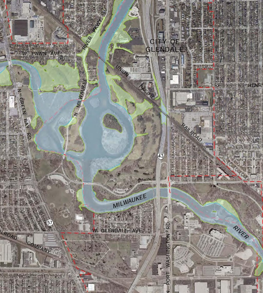
The flooding problems in this area were the focus for a study completed by SEWRPC in 2010 (A Watercourse System Plan for the Milwaukee River in Milwaukee County Upstream of the Milwaukee Harbor Estuary). The study was initiated by SEWRPC in 2006 in response to a request by Milwaukee Metropolitan Sewerage District (MMSD) for SEWRPC to perform hydrologic and hydraulic analyses and evaluate alternative floodland management plans for the main stem of the Milwaukee River in the 13.2-mile-long reach from the Milwaukee-Ozaukee County line downstream to the upstream limit of the Milwaukee Harbor estuary at the location of the former North Avenue dam. This segment represents the portion of the Milwaukee River for which MMSD has assumed jurisdiction for flood control purposes. The study included detailed maps of this section of the Milwaukee River showing both the locations of the 100-year flood plain (shaded green) and the 100-year floodway (shaded blue). Maps of the northern and southern portions of the impoundment area are presented below.

100-Year Flood Map for the northern portion of the Estabrook Dam impoundment, extending to approximately West Bender Road (modified from SEWRPC, 2010). The map was modified to both highlight the locations of W. Silver Spring Drive and W. Bender Road.
100-Year Flood Map for the southern portion of the Estabrook Dam impoundment (from SEWRPC, 2010).
The 100-year flood plain in the northern and southern portions of the Estabrook Dam impoundment have a significant qualitative difference. In the southern portion of the impoundment, flooding from overflow of the Milwaukee River and the lower ½-mile of Lincoln Creek during a 100-year flood event would potentially have no impact on buildings, with flooding restricted primarily to parkland. By contrast, the northern portion of the impoundment is bordered by extensive areas with homes and some commercial businesses located within the 100-year flood area and subject to flooding.
As part of the Environmental Assessment (EA) for the dam completed in 2014-15, hydraulic analyses were performed by SEWRPC on five dam removal or repair alternatives. The purpose was evaluate the effects of each alternative on water surface profiles under normal conditions (the long-term median and mean flows over the past 100 years) and for flood flows at 10 percent, two percent, one percent or 0.2 percent of the time (or every 10, 50, 100, and 500 years).
The modeling used the U.S. Army Corps of Engineers river analysis system computer program. The hydraulic model used as the starting point was the same used for federal flood insurance and local zoning purposes as described in the September 26, 2008, Federal Emergency Management Agency (FEMA) flood insurance study for Milwaukee County. The model was updated by SEWRPC for the dam evaluation by incorporating “bathymetric data” (i.e., elevations of the bed of the river) obtained as part of the sediment removal projects.The removal alternative was modeled assuming that the Estabrook Dam structure would be removed in its entirety. The modeled water levels were reported for approximately 140 locations along the Milwaukee River and the lowermost 1.17 miles of Lincoln Creek (which is influenced by flood levels in the adjoining portions of the Milwaukee River).
The most relevant data to the repair/removal debate are the flood levels modeled for removal of the dam, and the difference between these levels and the modeled water levels if the dam is repaired and remains in use. The table below summarizes the modeled water levels at four key reference locations on the River – at the dam, and at the crossings for Hampton Ave., Silver Spring Dr., and Bender Rd. Silver Spring Dr. is significant in that it represents the approximate southern limit of the area where homes bordering the impoundment are located within the 100-year flood zone. Bender Road marks the extreme northern limit of the Estabrook Dam impoundment. North of Bender Road are approximately 80 homes subject to flooding, but which would not be impacted by either dam alternative in terms of modeled future flood levels.
| Modeled Flood Stage Elevations for Repair vs Removal for Key Locations within the Estabrook Dam Impoundment | ||||
| Modeled Flow Condition | RM 6.829(8 ft. upstream from Dam) | RM 7.656(20 ft. downstream from Hampton Ave.) | RM 8.734(30 ft. downstream from Silver Spring Dr.) | RM 10.038(10 ft. downstream from Bender Rd.) |
| Modeled Flood Elevations (ft. amsl) – Existing Conditions & Repair Alternatives | ||||
| Median Flow | 616.89 | 616.92 | 616.98 | 617.40 |
| 10-yr Flow | 618.88 | 620.18 | 622.17 | 628.28 |
| 50-yr Flow | 620.05 | 621.78 | 624.18 | 630.42 |
| 100-yr Flow | 620.68 | 622.52 | 625.07 | 631.23 |
| 500-yr Flow | 622.18 | 624.11 | 626.91 | 632.82 |
| Modeled Flood Elevations (ft. amsl) for Dam Removal Alternative | ||||
| Median Flow | 609.44 | 611.50 | 613.58 | 616.88 |
| 10-yr Flow | 616.12 | 619.02 | 621.68 | 628.24 |
| 50-yr Flow | 618.29 | 620.99 | 623.83 | 630.39 |
| 100-yr Flow | 619.23 | 621.84 | 624.76 | 631.20 |
| 500-yr Flow | 621.11 | 623.55 | 626.64 | 632.79 |
| Difference in Flood Levels (feet) Between the Repair and Removal Alternatives | ||||
| Median Flow | -7.45 | -5.42 | -3.40 | -0.51 |
| 10-yr Flow | -2.76 | -1.16 | -0.50 | -0.04 |
| 50-yr Flow | -1.76 | -0.78 | -0.36 | -0.03 |
| 100-yr Flow | -1.45 | -0.68 | -0.32 | -0.03 |
| 500-yr Flow | -1.07 | -0.57 | -0.27 | -0.03 |
| Ft. amsl = feet above mean sea level; RM = river mile = distance in miles upstream from where the Milwaukee River enters Lake Michigan. Data are from SEWRPC study, April 25, 2014, presented as an attachment to the Draft Environmental Assessment Report of August 2014 prepared by AECOM. |
The most significant results are the modeled decreases in water levels that would result from permanent removal of the dam, which are shown in the lower third of the table. Key observations:
- In the area between Silver Spring Dr. and Bender Rd. where there would be a potential effect on homes subject to flooding, the maximum modeled decrease in the 100 year flood elevation is 0.32 feet. The modeled reduction in flood levels progressively decreases further upstream and is 0.03 feet immediately downstream from Bender Rd.
- The decrease in median flows is much more dramatic, totaling 7.45 feet at the dam, 5.42 feet at Hampton Avenue in the center of Lincoln Park, and nearly 3.5 feet at Silver Spring Drive.
The manner in which the flood modeling data have been presented to date appears to have contributed to significant confusion among the general public as well as local officials regarding the actual magnitude in the reduction of flood levels that might result from dam removal, as well as the number of homes that would experience reduced flood levels and/or be freed from federal flood insurance requirements. Although the model suggests that reductions of between 0.32 and 0.03 feet would occur in the elevation of water during a 100-year flood in the area between Silver Spring Dr. and Bender Rd., it is unconfirmed in the studies published to date whether any homes would in fact be removed from the 100-year flood zone (and the associated flood insurance requirements).
Although slight reductions in flood levels are modeled to occur, the magnitude of the rise in water level during a flood event would be nearly the same with or without the dam. Assuming the starting point for a rise in water levels occurring during a flood event was the river level associated with median flow, at Silver Spring Dr., the water level during a 100-year flood would rise from 616.98 to 625.07 feet amsl (an 8.09-foot increase) with the dam, and from 613.58 to 624.76 feet amsl (an 11.18-foot increase) without the dam. The peak elevation of flood water is modeled to be lower without the dam, but would by reduced by only 3 to 4 percent relative to the overall rise in flood waters that would still occur. At Bender Rd., based on the model, the magnitude of rise in flood waters during a 100-year flood would decrease by about 0.2 percent if the dam is removed.
Assuming that a 2 percent reduction on average occurred in the maximum flood elevation in this area of Glendale if the dam is removed, the shrinkage of the 100-year flood plain and the number of homes removed from this area might be expected to be a similar small percentage. My best guess is that 10 or fewer homes might be freed from federal flood insurance requirements if the dam is removed. As evidence of the confusion that currently exists regarding the impact of dam removal on flood levels, I received a communication from the City of Glendale on June 12th that noted: “If the dam is removed, then hundreds of Glendale homes that are listed as ‘floodplain’ will be able to petition to remove flood insurance requirements.” This is almost certainly not correct, and is potentially off by a factor of 20 or more.
The confusion has been exacerbated by seemingly inaccurate information presented by some advocates for removal. An example from the Milwaukee Riverkeeper website: “While the number of affected homes in the impoundment has been stated as around 300 during public meetings, the vast majority of those homeowners would like to see the dam removed due to flood risk posed by the Dam and the requirement to purchase expensive flood insurance due to Federal FEMA regulations.” The implication of this statement seems to be that the dam impacts the flood insurance requirements for hundreds of homes and those homeowners would benefit from dam removal and reduced flood levels, which is almost certainly incorrect.
Article Continues - Pages: 1 2
A Freshwater Controversy
-
The Path Forward for Estabrook Dam
 Feb 10th, 2016 by David Holmes
-
Estabrook Dam’s Environmental Impact
![Photograph of fish passing through the fish passage at the Mequon-Thiensville Dam. As of June 2015, a total of 35-species of fish have been recorded by a “fishcam” in the act of swimming past the dam [http://www.co.ozaukee.wi.us/1248/Fishway-Camera]).](https://urbanmilwaukee.com/wp-content/uploads/2016/01/image03-185x122.jpg) Jan 17th, 2016 by David Holmes
Jan 17th, 2016 by David Holmes
-
Repairing Estabrook Dam Will Cost Less
 Dec 23rd, 2015 by David Holmes


Why the controversy since the dam is always open anyway? The doors are never in the down/closed position so why not save all the money and just leave it alone?
Richard, that’s a good point… let it crumble into a new natural landform and it’ll be the cheapest by far. Probably a little artistic too.
We are grateful for the work of David Holmes and people like him at Urban Milwaukee. While other news outlets were reluctant for financial reasons, or afraid, too stupid or too lazy to check the facts and provide the truth, David Holmes and Urban Milwaukee are doing the hard and courageous thing. They are bringing us the whole story, both sides of it.
If the Estabrook Dam is removed, it would be the single most costly mistake Milwaukee County would make this decade. I believe the information in these David Holmes articles validate the messages I and my colleagues in the Milwaukee River Preservation Association have been saying for years. Milwaukee County Parks, at the direction of the county executive have been providing misinformation for the purpose of swaying public opinion toward dam removal. I believe they are determined to take the only boatable lake in the county away from the people of Milwaukee County. These decisions were made based on intentionally exaggerated figures. Plans were quietly made and implementation begun as thoroughly as possible without public input. Parks, DNR, and BLM steadfastly denied any facts that contradicted their goal of dam removal. Explanations were made so complicated and contradictory that most people were confused. The BLM even claimed ownership of part of the dam until irrefutable evidence proved them wrong and they backed-off in embarrassment. When public opinion was required by law, the Parks Department used every available technicality to make their reports appear as if the public supported dam removal, regardless of the overwhelming majority of responses supporting dam repair. When that didn’t work, Parks ran a second online survey and when that didn’t agree with their agenda, tried the same cherry picking tactics when reporting to the county parks committee. The Parks Department and DNR bureaucrats must already know that misinformation and crooked political maneuvers would be their only means to achieve dam removal because water law, economics and water science do not support their claims. Until David Holmes checked the facts, even he seemed convinced by the media and the “environmental community” that this dam was bad for the environment. To their credit, Milwaukee County Board of Supervisors lead by Chairman Lipscomb, were familiar with this kind of media and special interest pressure and supported their constituents. The board consistently approved dam repair. They budgeted and funded the necessary money in 2010, but bureaucrats who serve at the pleasure of the county executive hoped for a reversal and have managed to delay dam repair for more than 6 years since then. Bureaucrats continued to find technicalities for delay or reasons to make the county board vote over and over again.
Repair opponents lead by the Riverkeeper kept pressure on elected officials to remove the dam. Milwaukee and Shorewood passed resolutions supporting dam removal because of Riverkeeper pressure without even checking facts or opposing viewpoints with dam repair proponents. Even though most of the lake is in Glendale, City of Glendale mayor and common council were instructed by their legal counsel to not get involved. Glendale’s aldermen as well as the city attorney told me that municipalities were afraid of being drawn into costly lawsuits with the Riverkeeper and could not get involved. I believe donations to the Riverkeeper fund lawsuits against our county that cost tax dollars and support a bully with a bad agenda.
If Estabrook Dam is removed, it will require another Flood Insurance Study. That would include a new hydraulic study and elevation mapping for the portion of the Milwaukee River Watershed that falls inside Milwaukee County. This is an expensive process and most communities can only afford to pay for a flood study every 10 years or more. The National Flood Insurance program (FEMA) will not remove any homeowner from a Flood Hazard Map until there is data that supports flood risk from a 100 year event has been reduced for a homeowner. And only FEMA has the authority to accept or reject requests for map revision.
As David Holmes has suggested only a few homes may be removed from a flood map. But a new expensive Flood Study would be required by FEMA and no guarantee any homes would be removed from a flood hazard map. This information can be found in the FEMA website under Letter of Map Revision (LOMR).
I was previously swayed by various reports that dam removal made sense. I am glad that David Holmes has provided rigorous research and reporting that calls for reconsidering that approach.
Unfortunately, we live in a time where everything is reduced to sound bites and opinions or information the length of tweets. And media stories are often just composites of a few facts, some of which are merely recycled over and over.
Now that more data is out there I hope this issue will be analyzed in even greater depth by those with expertise. I fear it has become more of a political issue than a scientific or even economic one.
I know there are cases where removal of dams has made sense and been beneficial. However, the articles in this series question whether that is the case with Estabrook. I wonder if David Holmes might address that in a future article (or perhaps he has in this series and I missed it). That type of contrast might help to further clarify what perhaps are unique or at least exceptional aspects of this particular case.
The whole premise of this article is ridiculous. Let us think about it for a second. Why would the Estabrook dam prevent flooding up-stream of its location?
It wouldn’t!
A dam evens out the flow of water on the downstream side of the river. If the author of this article was really interested in preventing flooding in Glendale, wouldn’t a dam further up river that limits the water flowing down, wouldn’t that be the “solution” for dam happy people?
The Estabrook dam would limit the water from leaving, causing flooding upstream while saving areas downstream from flooding. This may have been necessary years ago but the river bank downstream of the Estabrook dam is now impervious to flooding until it reaches Lake Michigan.
So Tim, to sum up what you’re saying: You didn’t read the article.
This is a great series of articles.
One option that was dismissed in a single sentence in the last article was replacing the gates with a rock ramp (effectively a fish passage). This is exactly how the Theinsville dam is built.
As mentioned in the comments above the gates are permanently open, so a rock ramp would hardly change any flow at all.
I have to say until reading these articles I thought removing the dam meant removing the gates – big difference!
David I would really appreciate your opinions on replacing the gates with a fish passage, or rock ramp.
Thanks
AG, if you want to have a new dam built, why don’t you pay for it?
Just as tree roots can enter water lines and slow the flow and back up the delivery of water, the shallow areas of the river above the dam that have been exposed are overgrown with Cottonwood trees, Dogwood, Willow, Purple loosestrife and more, which will noticeably slow flood waters, back them up and cause the river to overflow it’s banks above the clogging constrictions. Just that simple. When the Estabrook dam was in operation it prevented those trees and thick shrubs from gaining any foothold on the river bed. Flood waters use to race by the house. Now the river is pulled on and slowed by tens of thousands of branches.
Tim, don’t be mad at me because you didn’t read the article…
But as a taxpayer, I would be paying to replace it. I’m ok with that.