
National Ave Could Get Protected Bike Lanes, Fewer Driving Lanes
But will accommodations be made for bus rapid transit or streetcar service?

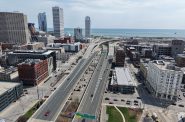
Proposed National Avenue street plan. Image from Department of Public Works/Wisconsin Department of Transportation.
A southside artery for autos could become a biker’s paradise under a proposal from the City of Milwaukee and Wisconsin Department of Transportation (WisDOT).
The preferred alternative for reconstructing W. National Avenue between S. 1st and S. 39th streets would see the four lanes reduced to two and raised, fully-separated bike lanes added.
The state-backed pavement replacement project was announced with great fanfare in early 2020, with then-Mayor Tom Barrett touting the state funding for what was imagined as a $25 million project to rebuild 2.6 miles of a key east-west street.
Area alderman José G. Pérez, now the council president, said in 2020 his first priority was safety for pedestrians and cyclists. “Ever since we were kids this has been a tough street to get across,” he said in an interview.
The $26 million proposal, released in a June public meeting, addresses the alderman’s priority and Mayor Cavalier Johnson‘s proposal to build or have planned 50 miles of protected bike lanes by 2026. The sidewalk-to-sidewalk right of way peaks at 90 feet wide, but east of S. 33rd Street only 22 feet of it would be driving lanes under the city’s proposal. A number of trees and other pedestrian protections would be added.
“Both meetings went very well,” said Department of Public Works major projects manager David Tapia to the Common Council’s Public Works Committee on Wednesday. “We didn’t hear anything that pushed us off of our locally preferred alternative.”
The segment west of S. 33rd Street to the city limits would still have four travel lanes, but would also receive the protected bike lanes. Throughout the entire length of the street, the protected lanes would be separated by a grass terrace.
Tapia said raised intersections, designed to reduce travel speeds, would be included at major cross streets. Side streets would receive raised crosswalks.
Construction on what is formally Wisconsin State Highway 59 is still several years away. Actual road construction would begin in 2026 and last at least two years. But portions of the street would be ripped out in 2025 for utility relocations, including replacing lead service lines.
“There will be another meeting next year where we will move into ‘okay, here is what the final design will look like,’ as well as construction and traffic control,” said Tapia.
Alderwoman JoCasta Zamarripa, who represents the area west of S. 20th Street, said she would like to see that meeting announced well in advance so more people can attend. She also pushed Tapia to have DPW better identify the Spanish interpreter during meetings and explain the open house format to attendees as they arrive.
The city will need to spend an extra $600,000 on designing the project, up from its original agreement of $1.57 million. Tapia said that a consultant must be hired to complete the design schematics in Autodesk’s Civil 3D software, which WisDOT now requires. “We are just starting to learn [Civil 3D],” said the project manager of the lack of in-house capacity.
Committee chair Robert Bauman maintained his concern that the city is moving forward on a design without considering laying streetcar tracks for a future extension. The current expansion plans call for running a line south through Walker’s Point to S. 7th Street and W. National Avenue.
“The road will be paved in asphalt,” said Tapia, noting that it would be easier to cut apart than a concrete street.
The DPW official said utility coordination work is also being done to avoid an issue that plagued the initial downtown route: utility relocations. “We will work with them to not go into locations where we think streetcar facilities might go,” he said.
Tapia also introduced another planning component: a future bus rapid transit line. He said Milwaukee County would like to upgrade the corridor after it completes its S. 27th Street project. “Lot of coordination,” he said. Bauman encouraged them to put in the stations today, noting existing buses could use the stops and then the street wouldn’t need to be dug up.
The committee unanimously endorsed the spending increase. The full council is scheduled to vote on the measure on July 31.
WisDOT maintains a project website with more details on past meetings and the project timeline.
Reconstruction Plans


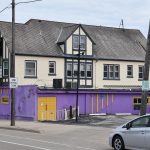
2020 Photo

W. National Ave. Photo by Jeramey Jannene.
If you think stories like this are important, become a member of Urban Milwaukee and help support real, independent journalism. Plus you get some cool added benefits.
Political Contributions Tracker
Displaying political contributions between people mentioned in this story. Learn more.
- February 20, 2016 - Cavalier Johnson received $250 from Robert Bauman
Transportation
-
Milwaukee Plans 60 Traffic Safety Projects for 2026
 Apr 8th, 2026 by Jeramey Jannene
-
State To Reveal New I-794 Cost Estimates
 Apr 7th, 2026 by Jeramey Jannene
-
Bus Riders Can Finally Pay With Credit Card
 Apr 6th, 2026 by Graham Kilmer


Looks like a wonderful improvement. I’d like to see how they will handle the intersections.
I’m all for reducing car lanes as much as possible. These plans (section 2, 6, 10) look amazing.