Which Sign Do You Prefer?
City, county want public input on signs for bicycle trails and city bicycle network.
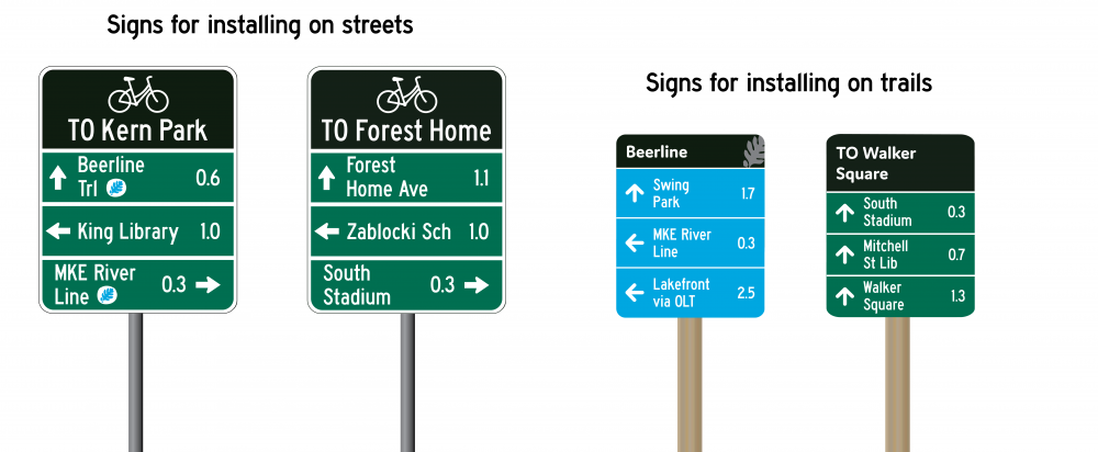
A sample of the visual preference survey sign options. Image from the City of Milwaukee.
The City of Milwaukee and Milwaukee County Parks want your input.
The city and county are working on a signage plan to help guide people around the city’s bicycle network and county’s Oak Leaf Trail. But before proceeding with installing wayfinding signage on 15 miles of high-priority routes, the partnership would like public input on different design options.
The 12-question visual preference survey is available until October 21st.
The signage is intended to identify the current trail or street and provide distances to upcoming landmarks. The off-street trail signage would be more colorful, while the on-street signage would be similar to many existing street signs as guided by the Manual on Uniform Traffic Control Devices.
The new signage would augment information kiosks installed along the Oak Leaf Trail in late spring and early summer. Those signs include a map that identifies nearby points of interest and trail segments and provides an etiquette guide for trail usage.The sign designs and priority routes are planned to be finalized between January and March 2020 with cost estimates on installation and a final sign guide for future signage prepared in April. Prototypes of possible signs have been installed at Gordon Park and Kosciuszko Park.
The partnership hired Maryland-based Toole Design to work on the sign implementation. The firm specializes in bicycle and transportation infrastructure. Associates in the company’s Madison and Minneapolis offices are working on the Milwaukee project.
A presentation in August by a representative of Toole Design emphasized that the final signage should be simple, consistent and designed for the inexperienced user.
The signage comes as the city and county have worked to expand their on-street and off-street trail networks in recent years. The city recently completed a protected bicycle lane on N. Hawley Rd and installed protected lanes on W. Kilbourn Ave. earlier this year as part of a broader network of safe biking streets in Downtown. The city approved a Complete Streets ordinance in 2018. Milwaukee County has worked to link segments of its off-street trails in recent years, including linking up the Oak Leaf Trail from Downtown to the Ozaukee County Interburn Trail that runs to Sheboygan County.
If you think stories like this are important, become a member of Urban Milwaukee and help support real independent journalism. Plus you get some cool added benefits, all detailed here.
Transportation
-
Scooter Users in Milwaukee Smash Ridership, Revenue Records
 Apr 13th, 2026 by Jeramey Jannene
-
Milwaukee Plans 60 Traffic Safety Projects for 2026
 Apr 8th, 2026 by Jeramey Jannene
-
State To Reveal New I-794 Cost Estimates
 Apr 7th, 2026 by Jeramey Jannene