A Riverwalk for Menomonee Valley
City unveils final design standards for unique trail emphasizing natural feel, connectivity.

Menomonee Valley RiverWalk. Rendering by HGA.
First introduced in 2017, a Common Council committee formally adopted design standards for a two-mile extension of the Milwaukee RiverWalk system Monday morning.
The extension will run along the Menomonee River from the river’s confluence with the Milwaukee River near N. 2nd St. and west to the 27th Street Viaduct and Three Bridges Park. That’s an approximately two-mile long corridor with the riverwalk planned for each side.
Like the Menomonee Valley’s redevelopment before it, the proposed valley riverwalk will have few peers nationally and even locally. The riverwalk won’t look much at all like what is seen Downtown; instead much of the planned riverwalk will consist of an asphalt trail, native grasses and strategically-sited tree groves.
Owing to the area’s predominantly industrial usage and history as a marsh, the riverwalk will function more as a trail along the river said Department of City Development planner Greg Patin.
“We wanted a document that reflected the uniqueness of the Menomonee Valley, but that was also clear and easy to use,” said Patin. The city, in partnership with non-profit Menomonee Valley Partners, issued an RFP in early 2018 to find a project consultant, ultimately hiring architecture firm HGA and engineering firm The Sigma Group.
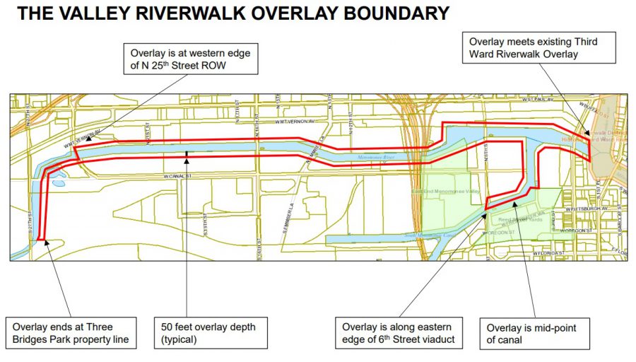
The final document isn’t a blueprint for the city to start demolishing properties in the way, but instead a guide for where and how new segments should be developed. The city, as is standard practice with the rest of the system, will pay 70 percent of the associated cost of building a new segment as properties along the river are improved.In 2017 the city passed a 50-foot overlay zone along each side of the river that governs the design of properties that are substantially redeveloped or newly constructed, encouraging more interaction with the river. The overlay zone sets aside 25 feet for the riverwalk corridor itself.
Design standards for the district mandate that the new trail segments must be at least 14-feet wide, compatible with Americans with Disabilities Act standards and open 24 hours a day. The asphalt paving would be 10 feet wide, with a two-foot-wide shoulder of crushed gravel running parallel to the paved trail on each side. Where space isn’t available on land, the riverwalk will have short segments over water.
Arboretum groves of at least 12 trees are envisioned every 300 to 600 feet, with concrete surfaces, lighting and benches. The change from concrete to asphalt is intended to warn cyclists of potential intersections and to better tolerate the root structure of the trees. Patin told the committee that connectivity into properties and the street grid is important to ensure the riverwalk is accessible.
The design standards also include landscaping designed to improve the environmental health of the river by reducing run-off through the use of permeable pavements, bioswales and native plantings.
Even with council approval, some segments of the corridor aren’t likely to see a riverwalk for generations, if ever. A gap will remain for the We Energies substation that is along the river across from the Valley Power Plant. In addition, there are a handful of parcels owned by Canadian Pacific Railway that aren’t likely to see riverwalk segments.
A small segment that complies with some of the standards already exists via the Hank Aaron State Trail extension that runs along the river near the city’s Department of Public Works facility and Marquette University‘s Valley Fields complex.
The Menomonee Valley design standards are far from the only riverwalk changes underway. As part of the Komatsu development in the Harbor District, a southern extension of the riverwalk is also being developed along the inner harbor and Kinnickinnic River. The previously planned Downtown and Historic Third Ward riverwalk is nearly complete with Trestle Park opening last summer.
The Menomonee Valley design standards will be up for adoption before the full Common Council on Tuesday, February 5th.
Menomonee Valley Riverwalk Plan
If you think stories like this are important, become a member of Urban Milwaukee and help support real independent journalism. Plus you get some cool added benefits, all detailed here.
Legislation Link - Urban Milwaukee members see direct links to legislation mentioned in this article. Join today
Eyes on Milwaukee
-
Church, Cupid Partner On Affordable Housing
 Dec 4th, 2023 by Jeramey Jannene
-
Downtown Building Sells For Nearly Twice Its Assessed Value
 Nov 12th, 2023 by Jeramey Jannene
-
Immigration Office Moving To 310W Building
 Oct 25th, 2023 by Jeramey Jannene