Brutal Winter Coming
Ice is forming on Great Lakes the soonest in more than 40 years, data shows.
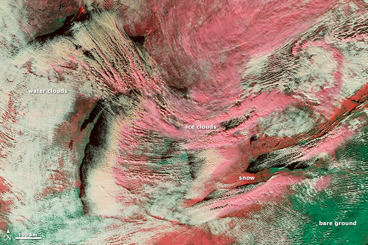
As dry, cool air rushed over the Great Lakes Nov. 18, it picked up moisture from the warmer water, creating long cloud lines known as cloud streets. In this false-color image, snow on the ground is dark pink, ice clouds are light pink and water clouds are white. Bare ground is green. Image: NASA
Ice is forming on the Great Lakes faster this year than any other.
Lake Superior had areas freezing on Nov. 15, according to Great Lakes Environmental Research data. That’s the earliest in over 40 years.
“Early ice formations this year are a product of years past,” said Jia Wang, who forecasts ice-climate for the National Oceanic and Atmospheric Administration.
During last year’s harsh winter, ice overtook Lake Superior from November until June. With only five months without ice, Superior—along with the other Great Lakes—remained unusually cold.
Coastal forecasting done by the administration show Superior’s water is two degrees below average for this time of the year.
“It all works as a part of a chain reaction,” said Drew Gronewold, hydrologist at the National Oceanic and Atmospheric Administration’s Great Lakes Environmental Research Laboratory in Ann Arbor.
Lingering ice meant less time for seasonal evaporation, keeping water levels unusually high and cold, said Gronewold.
“At a time in the year when we expect to see lake (water) levels dropping, the ‘big three’ are rising,” said Anne Clites, a physical scientist with NOAA.The big three refer to lakes Michigan, Huron and Superior.
Lake Michigan and Huron water levels drop five inches by this point normally, said Clites. Instead, the lakes are up nearly two inches. Same for Lake Superior—rising half of an inch instead of its usual two-inch decrease.
“When that happens, we expect to see less lake effect snow,” said Gronewold.
That, however, has not been the case so far this season. Extreme cases of lake effect snow gave areas like Buffalo, New York with seven feet of snow.
There is disparity between water temperatures in Lake Superior and Michigan, said Wang. The arctic air seen in November actually worked as a catalyst for lake effect snow.
“Arctic air is getting a boost from a cold Lake Superior,” said Wang. “Once that air arrives on Lake Michigan—which is warmer, you have the ingredients for lake effect.”
Wang thinks this is just a temporary trend.
“From what we can forecast, lake effect will dissipate in December,” said Gronewold, “once the northern air cools the lakes for good.”
That northern air is ultimately to blame for what Wang says will be a brutal winter.
“Cold, prepare for cold,” said Wang.
This story was originally published by Great Lakes Echo.
Great Lakes Echo
-
Tracking Balloon Debris in Great Lakes
 Dec 3rd, 2019 by Tasia Bass Cont
-
Coal Ash Pollutes Midwest States
 Jun 5th, 2019 by Andrew Blok
-
Extreme Changes Forecast for Great Lakes
 May 21st, 2019 by Cassidy Hough


What a remarkable image!