Downtown History Presents Opportunity in Milwaukee

Vista
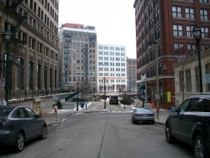
Cities in the Midwest will be competing for residents and tourists over the next century. Unfortunately, it will continue to be difficult for Milwaukee to compete with the likes of Chicago in terms of sheer volume. So Milwaukee needs to continue working to distinguish itself. Urban design and architecture are the most pragmatic way to accomplish this, as demonstrated by the Milwaukee Art Museum and Miller Park a decade ago.
Milwaukee’s beginnings offer the framework to continue to grow into an aesthetically distinguishable city. During the genesis of Milwaukee the competitive nature of its founders, Solomon Juneau and Byron Kilbourn, manifested itself in the town’s street layouts. The streets did not line up on opposite sides of the river. A walk down Water Street reveals how the competition between Solomon Juneau and Byron Kilbourn created a multiplicity of vistas that can be used to beautify Milwaukee today. Very few, if any, Midwestern cities have this advantage since the Jeffersonian grid system had wholly encompassed American Urban Planning by the time of any meaningful western expansion, leaving long straight streets with no termination opportunities even in high density areas.
The fact that the most urban part of Milwaukee is still along the historic core with its many functions and multiple vistas should be studied and implemented in the current and future development of downtown. The optimal component of beautifying these vistas is that most of the termination points also lie on the Milwaukee RiverWalk. Creating a beautiful city, founded on the past looking toward the future, will set a good example for future generations to continue to contribute to the pleasant and sustainable urban environment in Downtown Milwaukee.
Guest post by: Matthew Trussoni
Matthew Trussoni, PhD, PE, RA is currently an Assistant Professor in and an alumnus of the Milwaukee School of Engineering’s Architectural Engineering Department. After graduating MSOE he attended the University of Miami in Coral Gables, Fla. where he completed a dual master’s degrees program in the School of Architecture in 2005 earning the degrees of Master of Architecture and Master of Urban Design. In 2009 he earned his Ph.D. in civil (structural) engineering in the Civil, Architectural and Environmental Engineering Department. His professional experience has encompassed both architecture and engineering as he is a Registered Architect and Professional Engineer in the State of Florida.


Grant Park was never developed…and not all of pre-fire Chicago was destroyed. The historic cores of many Midwestern cities founded around the same time as Milwaukee are just as intact, relatively speaking, as the Brew City’s; and some older, even. Cincinnati and Cleveland both come to mind, as do myraid smaller cities. Milwaukee’s historic building stock is a major asset, no doubt. But if the city wants to distinguish itself, architecturally, it needs to do more to highlight that, as well as promote good contemporary design. Unfortunately, many of the buildings that have gone up in the past five years are absolutely forgettable, or even damaging (the positively atrocious condo tower on Burns Commons, at the terminus of the view down Farwell, springs to mind immediately). Milwaukee squandered much of the boom; hopefully, that won’t happen the next time around.
It’s a fabulous and frustrating time to live here.
Well written post, Matthew! I couldn’t agree more. Hope to read more of your thoughts here on Urban Milwaukee.
Great write up and very interesting to read! As a new resident to Milwaukee I’ve been very happy with the city’s urbanism and density in many parts. Riverwalk is awesome and a major, major asset/ competitive element the city has. And the third ward is great too. It’s unbelievable to me how dead downtown seems though. Particularly the myriad of empty store fronts. Downtown has a lot of potential, but Wisconsin Ave. really needs a major overhaul. If it wasn’t for the high rises it would be anything but urban.
Ben, having moved from Los Angeles to here, I must say Milwaukee is much, much less frustrating then LA was (as far as the “oh come on!” factor). Milwaukee is so much further along in some way in its urban thinking. Some trains would be a much welcomed addition and would go a long way to further the reputation and draw of the city. I think a huge reason Chicago has been so successful is because of their great transit system. There is no reason Milwaukee could not follow in the footsteps of similar sized city’s such as Denver, Pittsburgh and Cleveland who all have a train component to their transit authorities.
Great write up. I’m not really sure the block structure, in an of itself is going to be much of a tourist attraction. Rather, it’s about good attitude, pleasant places to stroll, and a “Real-ness” which you might be able to get in milwaukee that you might not get in, say, Orlando. The next frontier in international tourism once the furthest reaches of the globe are trodden? Why not!
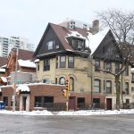
Got to this post from Infrastructurist… the old classically-styled buildings in the photo above are just lovely. However, as a favor to those of us who’ve never been to your fine city, perhaps you should consider posting/linking to some more images of the vistas you mean! 🙂
I’m a born and bred Milwaukeean. Milwaukee has its aesthetic sections, but it really has nothing to rival Pittsburgh, where I’m studying. Milwaukee has pretty strong topographical disadvantages to having much by way of vistas.
@A Smith! Thanks for visiting UrbanMilwaukee.com. Matt will be doing some followup articles on the Vistas and we’ll make sure to include more photos. Thanks Again.
@ Joe,
I agree with the notion that there have been many squandered opportunities during the peak years of the boom and we should learn from them for the next time around. None of the points made in the write up are meant as absolutes. Part of Grant Park was formerly Lake Park, part is landfill and part was buildings and urban fabric. In Cleveland a good portion of the original city was razed to make way for Burnham’s Group Plan of 1903. I am not that familiar with Cincinnati but I will have to take a look.
I’ve never head that part of Grant Park was urban fabric, please provide a citation.
Nor did “The great fire of 1871 wiped out the historic core of Chicago where Grant Park exists today”
see this map notice that the city ends at Michigan Ave. The Illinois Central tracks had water on both sides of them.
Antonio,
It would be nice if the link to your map worked, I would like to see the map. If you zoom in on this map:
http://en.wikipedia.org/wiki/File:Great_Chicago_Fire_map.jpg
You can clearly see that the streets extended to the east side of Michigan Avenue and that area was burned by the fire down to Congress Street.
It is also know by:
http://en.wikipedia.org/wiki/Grant_Park_(Chicago)
“The legal restrictions prohibiting any buildings in the park were ignored in the 1800’s, as various civic buildings were sited there.”
Perhaps if I knew what you are looking for I could be of more help to you. Why do you ask for the references?
A map of platted streets does not necessarily correspond to built-up areas. Fire insurance atlases would be a better source to prove the claim that an area was the center of a historic district. Also referencing the Wiki is poor. Find the primary source that the Wiki refers to. Google Books offers many primary sources of historical information if all you have access to is the internets.
It would be interesting to hear more about your definition of Milwaukee’s historic core and how it could relate to tourism. Your later article still skims ideas without getting into the details of how vistas are important.
Yes Wikipedia is a poor source, but is very convenient for people click when they are surfing this piece on the web. I first read about this in Daniel Burnham’s “Plan for Chicago” when I was in graduate school and did double check it with Wiki as I wrote this piece. After doing some extensive checking at the library the best book to look at is the Great Chicago Fire by Robert Cromie. There is a great map in there that shows the baseball stadium and buildings related to the railroad, in the park. If you are looking to see if it is the oldest part of Chicago, it is not, Fort Dearborn was north of this on the river. Montgomery Ward sued the City of Chicago in order make them remove the buildings that were built in this area after the fire, smart man. But I think you have taken us off the point of this piece.
I would argue, due to the street layout, that we have the opportunity to create a one of the greatest linear public spaces in America, if executed correctly. People like to be in pleasant pedestrian friendly spaces, the aesthetics of the buildings and how they affect the public spaces has a profound, even if not a conscious, effect on where people like to visit. It is common place in Europe but some American examples are State Street in Madison, Lincoln Road in Miami Beach and the San Antonio riverwalk. They have recently closed off Times Square in New York to traffic and we will see the same effect there. It would also connect almost all areas of downtown, including the Park East, via foot traffic.
William Whyte did a lot of work on studying these social phenomenons in his Project for Public Spaces in the 80’s. I read one of his books “The Social Life of Small Urban Spaces” as research for my Master’s thesis. Very interesting please check it out.