Tour Milwaukee’s Eco Neighborhood
Online map highlights points of interest in blossoming Lindsay Heights area.
While Yelp will guide you to Jake’s Deli or The Tandem restaurant, it’s not going to lead you to the nearby community gardens, green infrastructure projects and other neighborhood landmarks.
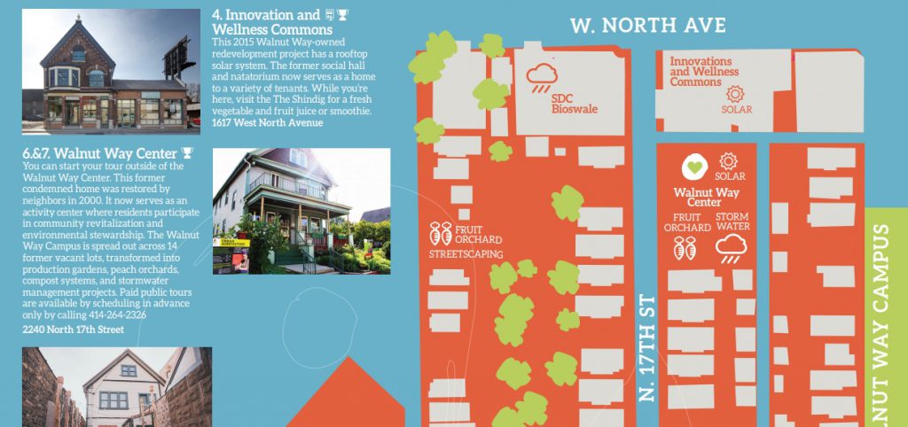
That’s why a partnership of the Walnut Way Conservation Corp. and the city’s Environmental Collaboration Office (ECO) partnered to make a map of everything that’s happening in the Lindsay Heights neighborhood.
The partners, along with 17 other organizations, gathered last week at the Fondy Farmers Market, to celebrate the completion of four new solar arrays, multiple bioswales and a host of other environmentally-sustainable improvements.
The EcoTour map, now available online, highlights the many projects centered around N. 17th St. and W. North Ave. It reflects the neighborhood’s status as the city’s first eco-neighborhood, a designation bestowed by the city’s ECO team on neighborhoods committed to sustainable change.
The map serves as a guide to see the area’s fruit orchards, bioswales, and solar arrays, but also will guide you to The Shindig (formerly the Juice Kitchen) for a smoothie or Ezekiel Gillespie Park for fresh raspberries.
The map was designed by Terrell Morgan. The signs dotting the area were created by Tim McCollow, Erica Heisdorf Bisquerra and Jeremy Davis.
Want a paper copy? You can pick one up at Walnut Way’s office on N. 17th St. or at a host of other neighborhood organizations.
If you think stories like this are important, become a member of Urban Milwaukee and help support real independent journalism. Plus you get some cool added benefits, all detailed here.
Eyes on Milwaukee
-
Church, Cupid Partner On Affordable Housing
 Dec 4th, 2023 by Jeramey Jannene
-
Downtown Building Sells For Nearly Twice Its Assessed Value
 Nov 12th, 2023 by Jeramey Jannene
-
Immigration Office Moving To 310W Building
 Oct 25th, 2023 by Jeramey Jannene


