
Riverwest Will Get First Bike Boulevards
Two miles of streets where bikes get priority over cars.
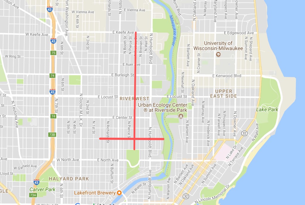
Proposed Bike Boulevards. Map by Graham Kilmer.
The Riverwest neighborhood will likely be the site of Milwaukee’s first “bike boulevards,” on a stretch of N. Fratney St. between E. Keefe and E. Meinecke avenues (connecting to Reservoir Park) and on E. Wright St. from N. Palmer St. to N. Gordon Pl.
“Bicycle boulevards, also called shared roadways, are low-volume streets where motorists share the same space,” a city Department of Public Works (DPW) publication explains. “Traffic calming and other treatments along the corridor reduce travel speeds to that motorists and bicycles generally travel at the same speed.”
Staff from the Department of Public Works will begin meeting with the design consultant, Toole Design Group, and others in early August. After which, Toole Design will develop the conceptual public recommendations for a public presentation.
The two bike boulevards will together create slightly more than two miles of priority street for bicyclists. The boulevard on W. Wright St will also connect to the Beerline Trail portion of the Oak Leaf Trail along the Milwaukee River.
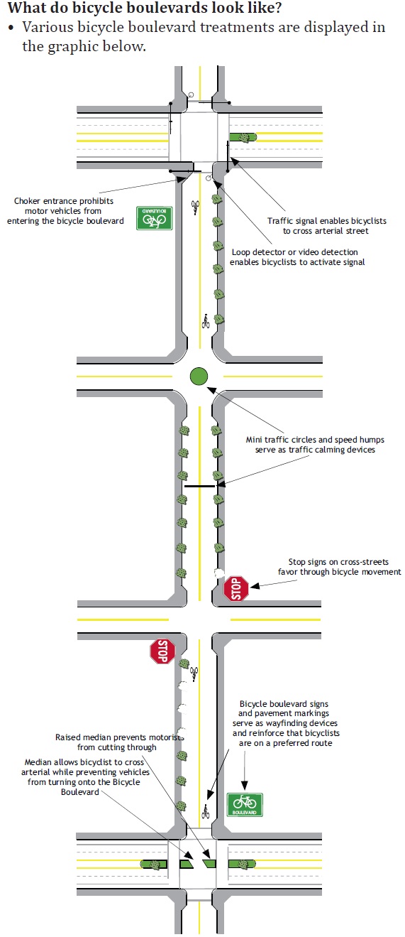
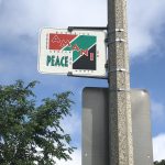
Bicycle Boulevard
Meetings for public input on the project won’t begin until Spring 2018.
James Hannig, the bicycle and pedestrian coordinator for DPW, said typical targets for bike boulevards are already low-speed, low-traffic streets. Then additional street signs, pavement markings and “speed management measures” are added.
“I like to think of it as making low-stress streets that are already pretty good for bicycling even less stressful,” Hannig wrote in an email. “Particularly at intersections.”
The street signs and pavement markings clearly demarcate at various points throughout the boulevard that this street has been set up for bicycle priority.
An explainer from the National Association of City Transportation Officials says the signs and pavings essentially work in tandem to “brand the route.”
When it comes to managing speed on a bike boulevard, anything from simple speed limit reductions to speed humps and curb build outs can be employed.
But for Milwaukee’s first bike boulevards, which are in the early planning stages, planners are looking at upgrading signalized intersections in order to “quickly and consistently pick up bicyclists on the corridor waiting to cross,” Hannig said. Also, there’s the possibility of replacing some four-way stops with neighborhood-scale traffic circles or, “similar traffic calming treatments to keep people on bicycles moving while maintaining neighborhood-appropriate travel speeds and discouraging cut-through traffic.”
Bike boulevards are another citywide infrastructure investment called for in the 2010 planning document, Milwaukee by Bike, which calls for the creation of 54 miles of bike boulevards.
Transportation
-
Milwaukee Plans 60 Traffic Safety Projects for 2026
 Apr 8th, 2026 by Jeramey Jannene
-
State To Reveal New I-794 Cost Estimates
 Apr 7th, 2026 by Jeramey Jannene
-
Bus Riders Can Finally Pay With Credit Card
 Apr 6th, 2026 by Graham Kilmer


We’ve had elements of these designs (choker entrance, mini traffic circle, speed humps) on Cambridge Ave from Hampshire south to Locust Street for years. Cars routinely disregard the stop signs at Kenwood Ave, travel miles above the speed limit, and pass vehicles that are actually trying to drive respectfully within that limit. Motorist primarily use the street to bypass Oakland Ave north and south between Hartford and Locust. Bicyclists are also at risk due to the poor condition of the road surface especially near the curbs. And any bicyclist trying to cross the Locust Street highway in either direction takes their life into their hands.
While the intent of the design elements are positive, they are useless if drivers ignore them. Driver education is part of the missing link here.
I’m super excited for this. Regarding: “The boulevard on W. Wright St will also connect to the Oak Leaf Trail along the Milwaukee River.” – how will that actually happen? Will there be a paved connection all the way to the east of the River that connects up? That would be fantastic. The current access / transition at Locust along Riverside HS is better than nothing, but not optimized for on and off access in the way this could be. Any more details?
Juli, I think the connection is to the Beerline trail that runs on the west side of the river. So to get from Wright St to the Oakleaf you will still need to cross the river at Locust or North.
Not a bad idea and as a resident of Milwaukee’s southwest side,I ride my bike on long distances and riding through Riverwest I see that this unique neighborhood has lots to offer.Drivers are mostly respectful.However,both drivers AND cyclists should always obey the rules of the road.I see way too many cyclists looking both ways and crossing against a fed light while the person in his or her is obeying the traffic signal.
Wright St west of Holton is in desperate need of traffic slowing devices. Despite the presence of an elementary school, drivers regularly ignore the 4-way stop signs there and pick up speeds far in excess of the required 25 mph for residential streets. They are using Wright as a by-pass for nearby North Ave. We need speed bumps and traffic circles to slow the unsafe drivers down, not easy-to-ignore stop signs.
This is great. To go with it, we need a SAFE bike crossing over the river near Locust Street.
The major problem for cyclists in this area is crossing the river safely. The Locust Street bridge is too fast and crowded for safety, and locust st intersections at humboldt and Oakland are impossible for cyclists to navigate. It doesn’t seem to me that bike boulevards solve the big problems here.
Locust Street between Humboldt and Riverside HS should be 3 lanes instead of 4. 1 each way and a turning lane.
Split the lane to give each side a bike lane, separate it from traffic with concrete barriers.
Cheap, effective… let’s have the city get a crane truck out there and restripe the street, it could be done in a week.
I heard…on this site actually…a rumor that a “road diet” was in order for the Locust St. bridge. Perhaps that will make the safe bike/ped crossing we all desire.
I’m cautiously optimistic on these bike boulevards. If they truly do keep the cars away or down or at least under control, I’ll be the first to offer my street for the next one!
Re: Locust St. bridge crossing.
I stay in the sidewalk and go through the park as I head east towards the Oak Leaf Trail. It seems to me to be the safest way to navigate the intersection. I’m not opposed to taking my bicycle off the road when necessary. In fact, I advocate doing it, out of safety concerns.
I would like to see more police enforcement of motor vehicle laws. No warnings.
There are rumblings of protected bike lanes for the Locust Street bridge. Thought that I heard the same for the North Ave bridge.
I agree with TGaudynski; my first thought was, “This isn’t the first, Cambridge already has this stuff.”
The intersection management will be key – Locust desperately needs a bike-oriented controlled intersection at Cambridge, since that’s a main access point to the large North/South stretch of the Oak Leaf, and people routinely drive 15mph above the speed limit there (also not great for the school, but at least the parking lot entrance has a stoplight). If they can manage the intersections along the proposed corridor well, it will certainly help make it a bike-friendly route, even without other features.
I’d love for the Locust bridge to be redesigned to better accommodate bikes, too, though I use that crossing at least daily on average (on the street), as well as navigating the Locust/Humboldt intersection, and I find it more irritating (becasue of the volume of traffic for which I must sometimes wait to move to the left turn lane) than unsafe. Still, there isn’t even a full bike lane becasue of the drains; it’s certainly not a friendly route, and given the distance between river crossings, it really needs to be.
Cambridge does indeed have some of these elements, and there are nonetheless a significant number of speeders (at least between speed humps) – but can you imagine Cambridge without the traffic-calming? It would look like Locust Street.
Resurface the road, add signage, and add all-way stops (or traffic circles) at every intersection, and you’d have a bike boulevard.
Re: #12…protected lanes on North Ave bridge…should include that hill westward towards Humboldt and a redesigned intersection there too. Under no circumstances does that stretch of North need to have two travel lanes plus parking, it’s nothing but a drag strip for the idiots, so take the excess half and make a true bike/ped facility walled off from the cars.
For years, I have tried to advocate for the stoplight at Newhall and Locust, which does NOTHING, moved to Locust and Cambridge, a most dangerous and busy intersection. With no right turns arrows for 5-10 seconds in each direction, allowing pedestrians and bike rider to cross safely across Cambridge on the north side of Locust and to the Oak Leaf Trail entrance that runs along Riverside HS, which also should be widened stightly to allow more room for both to share space. But to no avail. This would solve access problems safely. But I’ve heard excuses from the school having to move a couple of buss’s staging for 20 minutes twice a day to the bridge not being able to handle the weight of cars waiting. If that’s The case, the bridge needs to be fixed! As for “just repainting lanes,” where is the space for the extra lanes coming from?! There is NO room for 6 lanes. And where do the added lanes empty on both sides? It already narrows from 2 lanes to 1 on both sides.
Can residents still park on their streets or do bike boulevards means no parking on the street?
Well gee, ya, sure, nice concept, problem is what Milw. needs is to take money spent on studing all this and and get the idiot twins Barrett and Flynn to actually hire enough cops to enforce the traffic problems of the drivers that are killing us. Until thats done, this isn’t going to matter
SB, using cops to enforce speed limits and stop lights is a waste of tax dollars. These tasks can be automated (speed cameras and red light cameras) for zero net tax dollars–the fines exceed the cost of installation and maintenance. This would free up cops to go after misdemeanors and felonies.
Tom D.,
I think you meant to address Bob Vehring’s comment. I’m the one who’s asking how bike boulevards will affect parking. I love cycling and love that MKE is making moves to give cyclists a leg up; however, I live on N. Fratney with no off-street parking. I’m wondering how the bike boulevard will impact our ability to park on the street. Will it be a one-way street? Will there be parking on one side of the street? Or no parking on the street? Do I need to look at putting in a slab off the alley? If anyone knows the answers to these questions, I’m all ears.
The bike boulevards in Madison don’t affect having parking on both sides of the street. It wouldn’t be any different here.
SB, you’re right; I meant to direct my prior post to Bob Vehring.
As to your question, there is no reason for bike lanes to reduce parking when a “floating” parking lane is used. In this design, the bike lane is placed next to the curb and the parking lane goes left of the bike lane.
This 2-minute video illustrates how they work in NY City and in Copenhagen:
https://player.vimeo.com/video/20302720
This design is safer for cyclists because a line of parked cars greatly reduces the possibility of bicycle/automobile collisions. Floating parking lanes might even INCREASE parking availability at fire hydrants (because parked cars are far from hydrants).
Thanks for the explanation, Tom D. I remember cycling in Montreal and thinking, “Why doesn’t the U.S. employ these protected bike lanes!” But Fratney is only so wide so I’m assuming it would then become a one-way street? It doesn’t seem that there’s enough width for floating parking lanes on both sides of the street, plus the bike lanes themselves, plus traffic.
This is exciting though!