More Protected Bike Lanes and Greenways Needed
2015 agenda by Bike Federation will push city for these and other improvements.

Could Milwaukee we see protected bike lanes in 2015, like this one on Elston Avenue in Chicago? (Photo by Dave Schlablowske)
About 20 Bike Fed members met to create an exciting new list of advocacy goals for the Milwaukee area that includes protected bike lanes, bicycle boulevards and better maintenance of bike lanes. There were some new faces in the crowd of about 20 regulars who showed up for Milwaukee Metro Members Meeting recently at Anodyne Coffee in Walker’s Point.
After I gave a brief overview of new bike projects and plans for the area, we had a good discussion of which specific local advocacy goals we want to work towards this year. We worked from top down, beginning with where we would like to see the City of Milwaukee install protected bike lanes:
- S 1st Street, Maple to Pittsburgh
- Kilbourn Avenue, Water to Astor
- Martin Luther King Drive, North to Knapp
- Michigan Avenue, 6th to Lincoln Memorial Drive
- Van Buren Street, Brady to Kilbourn
We discussed other streets around the city, but everyone agreed the road segments on this list are either overbuilt for current traffic volumes or have such low parking demand that on-street parking could be sacrificed to allow for the extra room needed for protected bike lanes. Protected bike lanes have been proven to be the best way to get more people riding, and they work in cities with snow, like in Chicago, where they get just as much snow as we do. According to the Chicago Bikeways Tracker, they have 21 miles of their 100 mile goal for protected lanes.
Below are two videos I made of protected bike lanes. The first is in Washington, D.C., where I ride through a variety of protected lanes, some two-way, some one-way, but all are bollard protected. You’ll note that parking is outside the bollard protected buffer zone and the bikes are next to the curb instead of parked cars next to the curb and the bikes are next to the traffic lane as with traditional bike lanes.
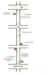
Click on this image to see a larger version. This is an example of the elements that might go into a bicycle boulevard.
The group also picked a few streets for bicycle boulevards or neighborhood greenways. Bicycle boulevards are side streets in which slow through traffic is optimized by removing stop signs and stringing together a series of traffic-calming devices to insure cars travel the speed limit and reduce cut-through traffic. Neighborhood greenways are not only great for bicycling, they end up being wonderful streets to live on because traffic and speeding is reduced. The traffic calming can also include beautification, like plants, and passive storm water management. Below is the list of streets the group has at the top of the list for neighborhood greenways:
- Fratney, a group in Riverwest is already advocating for this
- Washington Street, from 2nd to Chavez
- The signed bike routes that parallel S. 27 Street (26th and 29th) from Pierce to Greenfield
- S 37th Street, from Pierce to Greenfield
- Cambridge Ave., from Locust to Providence
A number of those streets, particularly Cambridge, already have the elements of a neighborhood greenway, they just need a few tweaks to make them work better for bicycling, like removing the stop signs for through traffic. Once you have all that traffic calming, you no longer need those stop signs, which should never have been installed in a misguided attempt to stop speeding and reduce cut-through traffic. All unwarranted stop signs do is encourage disrespect for stop signs.
Finally, the group is advocating that the city paint bike lanes on the remaining 20 miles of streets where they fit, and do a better job of maintaining the bike lane paint. The official policy recommendation is that the city of Milwaukee re-prioritize their painting program as follows:
- Crosswalks get painted first, in the spring
- Bike lanes get painted next, also in the spring
- Remaining long line program is painted next
- Bike lanes that wear out from traffic driving on them are maintained during the year along with center lines and fog lines
The group suggested the Bike Fed draft a letter to the Mayor, Commissioner of Public Works and City Bicycle and Pedestrian Task Force with these requests. The group felt that these efforts could also be part of the city’s effort to go from our current bronze-level bicycle friendly community rating from the League of American Bicyclists to a gold rating from the group.
Two representatives from the Southeast Regional Planning Commission (SEWRPC) attended the meeting and they suggested that we work with them and Kristin Bennett, the City of Milwaukee Bicycle and Pedestrian Program Manager, to do a more comprehensive review of Milwaukee’s 2010 bike plan’s recommendations for bikeways. They suggested such an effort would help them with the bicycle facility portion of their Vision 2050 planning process for the region. The group agreed with that suggestion and the Bike Fed offered to co-host a design charette.
Finally, I gave the group an overview update of all the bike projects for the area, from new maps to new trails. I will share that update with readers here in an article later next week, so stay tuned.
Bike Czar
-
Join a Bike Ride Under the Polish Moon
 Jun 1st, 2018 by Dave Schlabowske
-
9 Reasons to Join National Bike Challenge
 May 4th, 2018 by Dave Schlabowske
-
Biking Through the Mindoro Cut
 Apr 27th, 2018 by Dave Schlabowske











If you’re going to advocate for MLK, how about continue and do North Ave from there east to Kilbourn Park.
Bollards might decrease the amount that the “bike lane” gets used for 45mph cars passing everyone else.
And, I should’ve added, extending east on North would give the MLK route somewhere to go, by heading towards Beer Line and Oak Leaf connections at the river.
A project to make Cambridge a bike boulevard would ideally also incorporate an improvement to the bike-friendliness of Locust Street. Humboldt and Oakland have bike lanes both ways and the Oak Leaf Trail runs through the middle on both sides of the river, but Locust is a veritable motor speedway – a half-mile straightaway with no major intersections, and with marked bike lanes only on the bridge itself and westward between the bridge and Humboldt. Connecting the Oak Leaf Trail to the business districts on either side of the river would be a big improvement. Also, the Oak Leaf Trail exits onto Locust Street right where Cambridge begins, so slowing the car traffic on Locust is essential to connecting Cambridge with the Oak Leaf Trail.
Locust is an essential artery which can’t afford to make special accommodations for bikes. It’s already inadequate to the need.
One could restate that as “Locust is an essential artery which can’t afford not to have upgraded/dedicated bicycle infrastructure. It’s inadequate to the need.”
Good luck with this effort. I’d like to see these changes implemented.
One could restate that again as “Locust between Humboldt and Cambridge is a ridiculously overbuilt stretch of road that only encourages speeding” Yes, lots of cars use it, but that doesn’t mean it needs to be so wide and fast.
North Avenue used to be 4 lanes, somehow people are able to get where they need to with 2 lanes.
I drive Locust every day during “rush hour” (to the extent there is ever a “rush hour” here). The only place Locust gets an ounce of congestion during this time is between Humboldt and Holton. East of Humboldt, congestion would be an improvement because it would keep traffic closer to the speed limit.
We who live on the west side of Milwaukee could use some protected lanes and greenways. North Ave. in Tosa East Town is nice (although there’s little protection) but there are many more streets frequently used by bikers.
who is going to pay for these things? maintenance on these lanes, they are already off.