DNR Unveils Wisconsin PFAS Contamination Map
New site shows a number of contaminated Milwaukee sites.
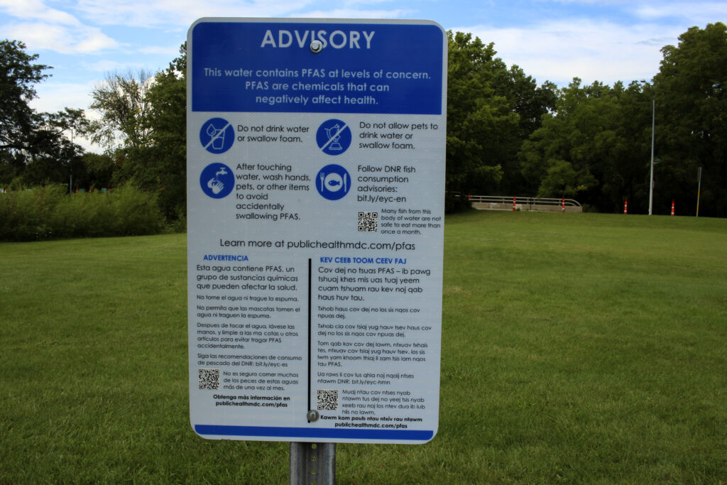
A PFAS advisory sign along Starkweather Creek. (Henry Redman | Wisconsin Examiner)
The Wisconsin Department of Natural Resources (DNR) released an interactive map on Tuesday detailing PFAS contamination in water sources and wildlife across the state.
The map, which tracks PFAS testing, levels in drinking water and fish consumption warnings, is the agency’s way to combine previously disparate data sources and inform residents about what’s going on with the water in their area.
“In Wisconsin and across the country, we continue to gather more data about PFAS,” Amy Johnson, director of the DNR’s emerging contaminants program, said in a media briefing Tuesday. “With easier access to information about the presence of PFAS, communities, policymakers and other stakeholders can make informed decisions to minimize exposure, develop plans for mitigation and access necessary resources.”Johnson added that communities across the state are going to get access to funding through the federal infrastructure law passed last year to mitigate PFAS pollution and that this data being in one location will help them plan.
“Making PFAS data available to the public is not new, PFAS data are plentiful,” she said. “But until this tool launched today, it required going to each data system separately to look for that information. The interactive data viewer compiles publicly available datasets about PFAS across Wisconsin in the water and land, fish and wildlife.”
PFAS are a family of man-made chemical compounds known as “forever chemicals” because they don’t break down easily in the body or environment. The chemicals, which can have harmful health effects, have been used in non-stick pans, fast food wrappers and certain kinds of firefighting foam.
The map shows locations in Wisconsin where there is an active PFAS cleanup site, where PFAS monitoring is taking place and where fish-consumption advisories have been issued.
The one-stop tool, which combines information from three separate DNR databases, was a recommendation of the Wisconsin PFAS Action Council, which was created by Gov. Tony Evers in 2019 to study the problem and coordinate efforts to reduce contamination.
PFAS, as the tool shows, are present in water sources across the state in communities big and small. In a news release, Evers said the tool will help the state work to improve water quality in those places.“The more information we can gather about how PFAS are affecting communities and individuals across the state, the better we can work together to get resources out to folks in these impacted areas,” Evers said. “With the unprecedented funding flowing into our state from the federal Bipartisan Infrastructure Law and with the investments we’ve been able to make at the state level, there are more resources than ever to help communities address these issues, including this new mapping tool, which contains incredibly valuable information to help advance our fight to address PFAS contamination in Wisconsin.”
DNR unveils interactive map tracking PFAS across Wisconsin was originally published by Wisconsin Examiner.
More about the PFAS Problem
- Wisconsin Conservation Voters Applauds Gov. Evers for Signing Historic PFAS Funding Bill - Wisconsin Conservation Voters - Apr 6th, 2026
- $80 Million In PFAS Grants Could Start Flowing This Fall - Danielle Kaeding - Mar 26th, 2026
- Wisconsin Conservation Voters Celebrates Historic $132 Million Pfas Victory - Wisconsin Conservation Voters - Mar 18th, 2026
- After Years of Delay, WI Legislature Passes Bills Addressing PFAS - Danielle Kaeding - Mar 17th, 2026
- Gov. Evers Celebrates Senate Approval of Bipartisan Pfas Compromise After Years of Urging Republicans to Release $125 Million to Fight Pfas Contamination Statewide - Gov. Tony Evers - Mar 17th, 2026
- Gov. Evers Signs New PFAS, Lead Regulations - Danielle Kaeding - Mar 2nd, 2026
- Gov. Evers Builds Upon Efforts to Clean Up Wisconsinites Water, Approves New Rule Changes Strengthening Pfas Drinking Water Standards - Gov. Tony Evers - Mar 2nd, 2026
- PFAS Levels in Great Lakes Fish Are Dropping - Danielle Kaeding - Feb 6th, 2026
- Gov. Evers and GOP Lawmakers Near a Deal on PFAS Pollution - Danielle Kaeding - Jan 22nd, 2026
- Gov. Evers Optimistic About Reaching Final Deal With Republican Lawmakers to Secure Release of $125 Million in Long-Awaited Pfas Investments - Gov. Tony Evers - Jan 21st, 2026
Read more about PFAS Problem here