New Plans Aims To Grow 13th Street
Extension of KK River Trail, traffic calming for Oklahoma Ave and safety improvements for S. 13th Street.
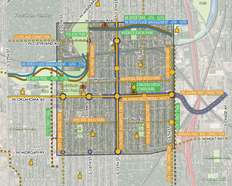
Envision South 13th Street Together project map. Image from DCD.
A new neighborhood plan aims to guide the future of the S. 13th St. commercial corridor and surrounding Polonia neighborhood between W. Harrison Ave. and W. Morgan Ave. Action items include better integrating the Kinnickinnic River with the neighborhood, a potential street festival, and traffic calming improvements to improve pedestrian safety and develop a sense of place.
Dubbed the Crisol Corridor, S. 13th St. and the area around it, has seen a growing amount of new investment, a business improvement district formed in 2015 and a generational vision developed to cleanup the Kinnickinnic River. The name “crisol” is Spanish for melting pot. The area was first settled by Polish immigrants in the 1870s and by 2010 the area’s population was 62% Hispanic and included a growing Asian community.
“It became clear a plan was needed to pull together all of these ideas,” said Amy Oeth, senior planner with the Department of City Development, to members of the City Plan Commission on Feb. 14.“Envision South 13th Street Together” is a strategic action plan from DCD that aims to align residents, business and property owners and the multitude of government partners operating in the area, including the Milwaukee Metropolitan Sewerage District, Sixteenth Street Community Health Centers, Crisol Corridor BID #50 and city.
More than 50 projects were identified and categorized as either economic development, streets & transportation, general safety, community building, outdoor recreation, stormwater & flood management or placement & art. The plan lays out next steps, potential funding sources, responsible parties, opportunities for coordination and sequencing and project timeframes for each.
Because the planning effort started as the COVID-19 pandemic took hold, community engagement was entirely virtual. DCD planning manager Sam Leichtling said he was proud of the project team’s efforts to maintain community engagement during an uncertain time.
Residents and stakeholders still made their concerns clear. Oeth said safety was a big topic, including everything from pedestrian safety to working with the Milwaukee Police Department to better monitor Pulaski Park and other areas.
Bike boulevards, a treatment that discourages high-speed through traffic, are envisioned for multiple side streets while a westward expansion of the Kinnickinnic River Trail along the river corridor is planned. The trail would ultimately extend beyond the plan area to S. 27th St. and Jackson Park.
The trail gets to the core of DCD’s desire to create the plan: coordinating investment to improve outcomes.
MMSD is already engaged in a multi-year, several-million-dollar effort to naturalize the concrete-channeled river corridor to alleviate flooding. Adjacent to the river is Modrzejewski Playfield, which Milwaukee Recreation is initiating an overhaul of. The Department of Public Works and other stakeholders have envisioned extending the paved KK River Trail west from S. 6th St. for years. Near S. 16th St. MMSD and Milwaukee County Parks just celebrated the completion of a revitalization of Pulaski Park and the portion of the river that runs through it.
The plan, similar to one released in 2020 for the area around Century City, aims to bring all of those disparate projects together while also timing them with basic public infrastructure projects like sewer repair and street paving.Envision South 13th Street Together also includes a vision for 13th Street itself. The plan envisions the creation of a “complete street” safe for all road users of all ages as well as design and land-use guidelines for area properties.
“We want to be able to help that small vacancy rate grow even smaller, but we want to improve the visual appearance on the outside of those properties,” said BID director Leif Otteson.
The City Plan Commission unanimously endorsed the plan. The full Common Council is expected to review it in the coming weeks. The area straddles the districts of council members Jose G. Perez, Marina Dimitrijevic and Scott Spiker.
Plan
Political Contributions Tracker
Displaying political contributions between people mentioned in this story. Learn more.