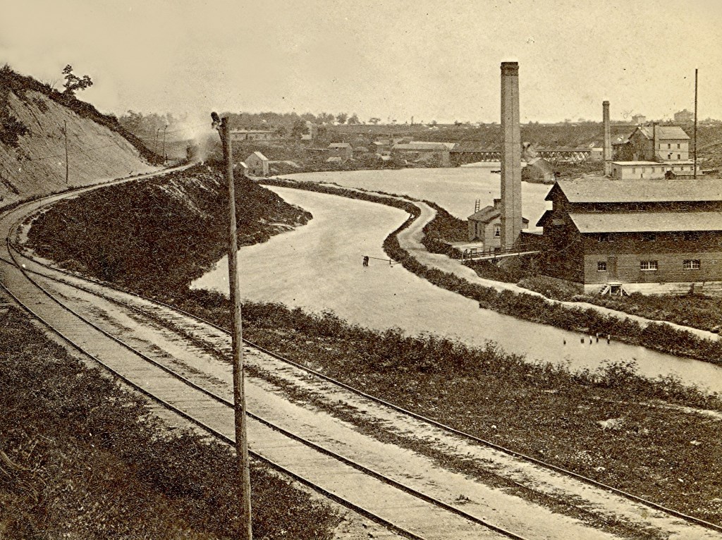
Milwaukee’s Canal, Mid 1860s
The canal was one mile long, but never grew as the company went bankrupt.
Last week’s photo was was of the Milwaukee River dam which was completed in 1842. The purpose of the dam was to construct a canal between the Milwaukee and Rock rivers in order to connect with the state’s rich agriculture lands and eventually with the Mississippi River, thus connecting it to Milwaukee and Lake Michigan.
This is a mid-1860s view of the portion that was completed, approximately one mile long. At the right is a towpath that never was used as well as a mill. The canal was a very convenient source of water power which was quite important at this period of the 19th century. The bridge to the left-center is the site of today’s Humboldt Ave. bridge. At this time, though, Humboldt Ave. south of the river was named Racine St.
Note that the river was considerably wider back then. From this area to the river’s mouth there was considerable landfill along the stream to be used for development.
This photo’s viewpoint is just west of what is now the location for Lakefront Brewery.
Do note the railroad track. This was the Milwaukee & La Crosse which was completed in the mid-1850s. The line would end at a depot near 3rd and Cherry streets. In later years it would earn the nickname the “Beer Line” as this depot would become the primary shipping point for the Schlitz and Pabst breweries. The building at the top-center is a roundhouse for the railroad in what was called the “Humboldt Yards.”
Jeff Beutner is a collector of photographs, postcards and stereoviews of old Milwaukee. This column features these images, with historical commentary by Beutner.
Yesterday's Milwaukee
-
When Boston Store Was Big
 Apr 18th, 2018 by Jeff Beutner
-
Sherman Park Has Been a Melting Pot
 Aug 25th, 2017 by Jill Florence Lackey, PhD
-
The Rise and Fall of Bronzeville
 Aug 5th, 2017 by Jill Florence Lackey, PhD

