Milwaukee County Residents Invited to Provide Feedback on Proposed 30th St Corridor Bike and Pedestrian Trail Concepts
Public Information Meeting Included Three Alternative Trail Concepts as Part of the 30th Street Corridor Trail Feasibility Study
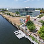
(Milwaukee) – The Milwaukee County Department of Transportation (MCDOT) is looking for public feedback on bicycle and pedestrian trail concepts that could connect Havenwoods State Forest to the Hank Aaron State Trail along the 30th Street Corridor, significantly increasing community access to the regional trail network. Community members are invited to provide input on the trail concepts until May 22 at county.milwaukee.gov/30th-St-Trail-Study .
“Bicycle and pedestrian trails are an important part of our transportation network, especially in Milwaukee County where we are working toward transportation solutions for a large nondriving population,” said Joe Lamers, MCDOT Director. “Expanding transportation options that work for all of our residents can help create a safer, healthier, more connected community.”
The alternative trail concepts were shared Tuesday, April 28, during a public information meeting at the Havenwoods Environmental Awareness Center as part of the 30th Street Corridor Trail Feasibility Study. The study aims to evaluate options to connect Milwaukee’s northwest side neighborhoods to the local trail network. There are three alternative trail concepts:
- “Corridor Direct” Trail Concept: This option primarily follows the railroad corridor, with a proposed shared-use trail elevated next to or over portions of the railroad so as not to impede existing or potential future freight rail operations. Most of the 30th Street Corridor railroad right-of-way is private property, and the owners have not granted permission for public use, including the proposed trail. If permission were granted in the future, this route would provide the most continuous, uninterrupted trail option.
- “Greenway Link” Trail Concept: This option focuses on connecting trail users to parks, river greenways, and natural areas through a combination of on-street and along-rail trail segments. This route would provide more direct connections to the Oak Leaf and Beerline trails but is the least direct option. This route would require floodplain regulatory approvals due to the addition of new structures within or near waterbodies, as well as railroad approval for the segments along the rail corridor.
- “Explore the Neighborhoods” Trail Concept: This option focuses on routing the trail through nearby neighborhoods primarily utilizing existing public right-of-way. It would be the most accessible route for residents and provide additional benefits through investments in safer streets. This option does not require any use of the railroad corridor and minimizes regulatory approvals. However, this route includes the most at-grade street crossings, and the addition of a separated trail along existing streets may cause conflicts with neighboring homes and businesses.
Public feedback on the alternative trail concepts will be used to create a preferred plan that reflects the community’s priorities and the physical constraints of the corridor. The study will be completed in 2027. Construction of a trail will be dependent on jurisdictional oversight and authority, as well as the ability to obtain funding.
The 30th Street Corridor’s Role in the Regional Trail Network
Residents on the northwest side of Milwaukee have limited access to bicycle and pedestrian trails. The 30th Street Corridor has been identified as a key missing segment in the regional trail network.
“Creating safe, accessible, bicycle and pedestrian access along the 30th Street Corridor would be one of the most impactful trail projects in the Milwaukee County region,” said Willie Karidis, Rails to Trails Conservancy’s Route of the Badger Project Director. “Completing this study is another step toward significantly increasing equitable trail access to grocery stores, schools, employment, and nature.”
Trail access along the 30th Street Corridor could complete an 18-mile Milwaukee Loop, including portions of the Hank Aaron State Trail, the Oak Leaf Trail, and the Beerline Trail.
About the 30th Street Corridor Trail Feasibility Study
MCDOT is facilitating the 30th Street Corridor Trail Feasibility Study through a Wisconsin Department of Transportation (WisDOT) Transportation Alternatives Program (TAP) grant. MCDOT has engaged engineering and design firm SmithGroup to lead the study.
The Study builds upon the City of Milwaukee’s Connecting the Corridor Near North Side Strategic Action Plan and the Rails to Trails Conservancy’s 30th Street Corridor Shared-Use Trail Preliminary Study by partnering with leaders and organizations from the previous studies to provide input, experience, information, and data.
Tuesday’s meeting was part of the Study’s second round of public engagement. The final round of engagement is anticipated in the summer of 2026.
More information is available at: county.milwaukee.gov/30th-St-Trail-Study.
NOTE: This press release was submitted to Urban Milwaukee and was not written by an Urban Milwaukee writer. While it is believed to be reliable, Urban Milwaukee does not guarantee its accuracy or completeness.
Mentioned in This Press Release
Recent Press Releases by Milwaukee County Department of Transportation
Milwaukee County Residents Invited to Provide Feedback on Proposed 30th St Corridor Bike and Pedestrian Trail Concepts
Apr 29th, 2026 by Milwaukee County Department of TransportationPublic Information Meeting Included Three Alternative Trail Concepts as Part of the 30th Street Corridor Trail Feasibility Study