
MMSD Project Will Reduce Flooding in Jackson Park
Effort to re-naturalize the Kinnickinnic River and remove concrete channels moves west.
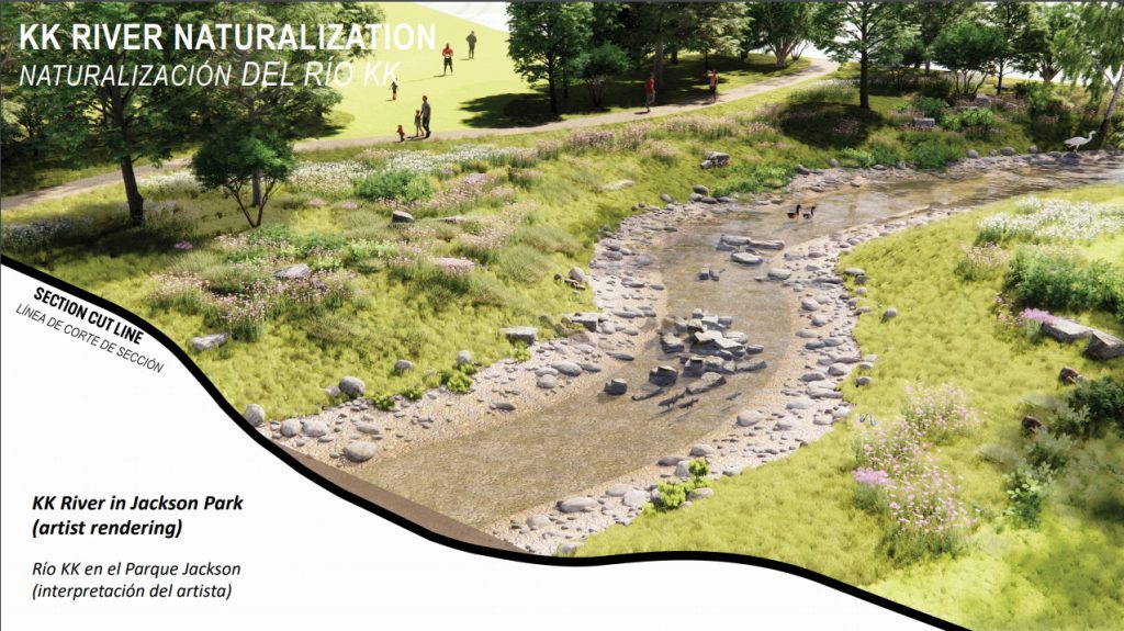
Rendering of naturalized Kinnickinnic Riverbed. Image from MMSD.
The Milwaukee Metropolitan Sewerage District (MMSD) is taking its effort to re-naturalize the Kinnickinnic River, and prevent flooding, to Jackson Park.
Back in the 1960s, MMSD lined sections of the Kinnickinnic River and its tributary streams with concrete, turning them into drainage ditches to rapidly drain stormwater out of the area and into Lake Michigan.
Over the years, however, it became clear that the channels cause flooding along the Kinnickinnic River and dangerous, fast moving water flows following a heavy rain. And nowadays there are more heavy rain events. In 2022, three people died after being swept away by the water flowing through the channel after a heavy rain.
“We describe it as really flashy,” said Patrick Elliott, a project manager with MMSD, with extremes of both high and low water levels on the KK river between rain events.
And so the MMSD has reversed course over the last decade or so, working to re-naturalize the Kinnickinnic River watershed, which is the most densely populated and urbanized watershed in the state of Wisconsin. More than 600 homes and commercial buildings sit within the 100-year floodplain, according to MMSD. The effort has now moved to Jackson Park, where the MMSD is removing the concrete channel, giving the river room to spread out during heavy rainfall and expanding its ability to hold stormwater, thereby reducing flooding and dangerous stream conditions.
MMSD is also partnering with Milwaukee County Parks to add new parks amenities in Jackson Park. Construction will begin this spring on the $80 million project, with construction of new recreational facilities in the parks. Construction on the riverbed is expected to begin in 2026, Elliott said.
“It’s like a funnel,” Elliott said, describing the watershed. “All the precipitation, snow, rainfall that falls within this area, it all falls within this funnel, and it all drains to one place.”
As stormwater moves through the funnel during a rain event, it gets backed up by obstructions along the narrow, outdated channels. Between S. 6th Street and W. 16th Street in the Lincoln Village neighborhood, bridges and culverts cause the rushing water to spread out and flood nearby homes and commercial buildings. MMSD plans to eventually re-naturalize this strip, removing the concrete channels. In the meantime, it has acquired nearby buildings sitting in floodplain and removed them.
Adding stormwater capacity west of the neighborhood, nearer the top of the funnel, in Jackson Park, will reduce the amount of water rushing through the channel toward the area Between S. 6th Street and W. 16th Street prone to flooding.
The sewerage district will remove 2,100 feet of concrete channel and culverts. The Jackson Park lagoon will be dredged so it can hold more stormwater. North of the park, MMSD has demolished a former We Energies building and is developing a detention basin there to hold additional stormwater. MMSD is also investing in updated parks amenities, including a new open air pavilion to replace the boat house, a new trail layout, sport courts and a new soccer fields.
“So it’s really a win-win for the public, for the Milwaukee County taxpayers on this, because we can really double the benefit of those dollars spent,” Elliott said.
The channel running through the park will be naturalized, or returned to something that more resembles a natural water way. Which will be a big change. “This is not a stream,” Elliott said. “This is a concrete ditch. It’s an open sewer.”
An example of what it will do in Jackson Park can be found in nearby Pulaski Park, where MMSD removed 1,700 feet of concrete channel between 2018 and 2020. Once the concrete is removed, the riverbed is widened to provide more room for stormwater during a rain event. Native plantings go in along the bank and rock is used to “lock” the channel in place, which is difficult as rivers tend to “want to do their own thing,” Elliott said.
Then it begins to actually look like a stream again.
“And that’s what we really need in these areas,” Elliott said. “We need these urban streams.”

Existing members must be signed in to see the interactive map. Sign in.
If you think stories like this are important, become a member of Urban Milwaukee and help support real, independent journalism. Plus you get some cool added benefits.
MKE County
-
Incumbents Sweep County Board Elections
 Apr 7th, 2026 by Graham Kilmer
-
Federal Judge Won’t Vacate Dugan Conviction
 Apr 6th, 2026 by Graham Kilmer
-
Sup. Vincent Faces Challenge in Heated Race for District 11
 Apr 6th, 2026 by Graham Kilmer


Aren’t most of the lagoons in Milwaukee County Parks giant concrete lined structures as well? Is scooping the sediment out of it out going to fix this for the long term…without being made to actually dig it deeper? And as for MMSD clearing out the concrete. I live very close to one of those areas that they “improved” by ripping out the concrete along the creek. But the trouble is, they found that by naturalizing the creek, they suddenly needed to declare cattails (aka sausage tails) as an invasive species that needs to be cleaned or burned out in order to allow the water to flow in the heavy rains to avoid it overflowing.