One Way to Replace The Hoan Bridge and Build a Better Milwaukee
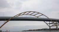
The Hoan Bridge
The replacement of the Hoan Bridge and its associated freeway ramps with a grade level route offers many opportunities but will also require the rerouting of a portion of the 40,000 motorists that travel over the Hoan Bridge each day. Although 40,000 motorists seems like a lot of traffic, history has shown in both the removal of the Embarcadero Freeway in San Francisco and the Park East Freeway here in Milwaukee that traffic patterns will change and the grid system will be able to support the rerouted traffic.
To put this rerouted traffic on to the grid a few changes will be required to link the Lake Parkway in to the system. First I-794 should be replaced with an at grade extension of the Lake Parkway. Although this will undoubtedly cause the loss of federal dollars it will also reduce some of the traffic taking this route merely by removing the interstate from maps. The road itself could be rebuilt as a parkway which would run in the current footprint of the freeway and then turn west to connect with Greenfield Avenue across a new bascule bridge. Although once across the river the majority of the traffic would follow S. 1st Street into downtown, with the addition of a rebuilt S. Barclay Street and a new bascule bridge connecting Walker’s Point to the Third Ward the traffic could find a multiple of routes into downtown. To facilitate this rebuilding of the grid some properties on both sides of the river will need to be acquired but this is surly less expensive than a complete rebuild.
This is just one idea of how to possibly replace the Hoan Bridge and create a better Milwaukee in the process. Surely the Wisconsin Department of Transportation (“Wisconsin DOT”) will be investigating a variety of options in the coming months but hopefully the Wisconsin DOT will look at this as more than a demolition project and find a way to work with the city to build a better Milwaukee.
View Larger Map
If you think stories like this are important, become a member of Urban Milwaukee and help support real, independent journalism. Plus you get some cool added benefits.











I think the Hoan should be replaced with a cool looking cable-stayed bridge…It would be very aesthetically pleasing, and at night it would have a neat lighting system. Something that would complement the Art Museum and add to the skyline in that it could look like a sail boat.
That is an interesting idea as well and I like the cable-stayed bridges. Though for my dollars I’d like it all removed and put onto the grid somehow to open up the land for other uses. I didn’t mention it in the article but rerouting the hoan traffic as laid out in my “proposal” would also allow for freeway removal through the Third Ward and the possibility of creating a greenbelt along the Summerfest grounds as well..
Although I generally support many of the “urban” changes to Milwaukee advocated on this site, this idea is simply asinine. My cursory review of the situation yields the following reasons:
1) There is no developable land on Jones Island: No one wants to live next to a sewer treatment facility (ever driven on the Hoan Bridge with your windows down in the hot summer sun?). While in retrospect it probably wasn’t smart to place the city’s sewer facility so close to downtown, arguing against that is irrelevant. The other heavy-industrial uses of the land are not affected by the presence of the freeway.
2) The Walker’s Point/5th Ward neighborhood will not be developed by the existence of commuter traffic from the South suburbs. If anything, heavy traffic will prevent a pedestrian-friendly neighborhood. Growth will only be spurred Southward from the 3rd Ward as housing and business space is fully occupied and tenants look elsewhere but still desire to be close to downtown.
3) The WisDOT spent $810 mil upgrading the Marquette Interchange to handle a traffic pattern heading to and from the South suburbs on I-794. Whether or not one agrees with this past money and traffic allocation is irrelevant: it’s already done. To then demolish the bridge portion of I-794 would create a new stubby freeway spur about which we can whine.
The solution would be a new bridge (or modifications) which would allow cycling traffic (a pedestrian bridge suspended underneath?) and has exit ramps to and from the 3rd Ward (the original ramp patterns were designed before the revival of this area). While we’re at it, might I suggested a redesign of the interchange at the Port of Milwaukee? That ramp and road system doesn’t make sense by any standards…
Agreed there wouldn’t be much in the line of development on Jones Island, and I don’t point to any. Though putting traffic on the grid in Walker’s Point surely would spur business. One of things that retail establishments always look for are traffic counts prior to opening.
Further I didn’t get into it but removing the Hoan should allow for parts of I794 to come down, possibly creating a grander entranceway to Summerfest/MAM/Discovery World. And finally a greenbelt park could then be built along Summerfest in the Third Ward adding to property values and again creating a grand entrance to Summerfest. Some development may also be possible in the Third Ward (this is debatable because of legal issues).
The Hoan was built to its height to accommodate large vessels. I believe it is rather tight within the Coast Guard regulations for height. Any grade-level replacement bridge must be a bascule bridge, since a lift bridge would be impracticable. You just couldn’t make it high enough, unless you build some crazy Tower Bridge structure.
Horne
@Michael Good point I was thinking bascule bridge but typing lift bridge. I’ve updated the article.
I don’t think relocating Kaszubes park will be an issue, if you look at the satellite view it seems to be occupied not by grass and trees but by shipping containers…
@Matt I looked at Google Streets of the park and it is a very small greenspace squeezed between the containers and another facility. It’s actually kind of funny how small it is. Anyhow that was part of my thought by moving it and using the debris you could actually create a bigger park although further east and south.
I can’t help but think that something like the tower bridge in london would make an amazing way to frame the entrance to the harbor, while keeping the street at grade.
Or any sort of raised bridge…. http://flickr.com/photos/kworth30/2276010619/
Don’t do it, that thing is a Milwaukee landmark! Rebuild, upgrade, restore, just don’t change it too much. Think of all the marketing based on that bridge. (although that new museum is becoming a Milwaukee Icon) On second thought, leave it alone, it’s not a very usefull freeway anyways, no way I want my tax dollars going to a new bridge to nowhere.
Dustan
Floor care tips
Good article.
I agree that the removal of the roadway, won’t have a terrible impact on street level traffic. I have always thought that I-794 was underutilized. Even before traveling the route, it’s Interstate designation appears pointless from any map. I am aware that 794 is part of a grander freeway plan for Milwaukee that never materialized.
Conversion of 794 into a tree-lined arterial probably would allow for development along the E-W portion of the route [ river valley and canal zone South of downtown.] However, I don’t know what can be done on the Lakefront area abutting 794, as one of your readers has already pointed out.
@Kofi Well my specific thought on it was just one far out idea of what could be done. But the actual plan as looked at by the DOT would open up new land in the Third Ward for redevelopment which could become some of the most prime land in the city. That would be a huge benefit in and of itself.