County Seeks ‘Missing Middle’ Housing for South Side Land
Hoping for affordable townhomes to be developed on vacant land at S. 6th Street.
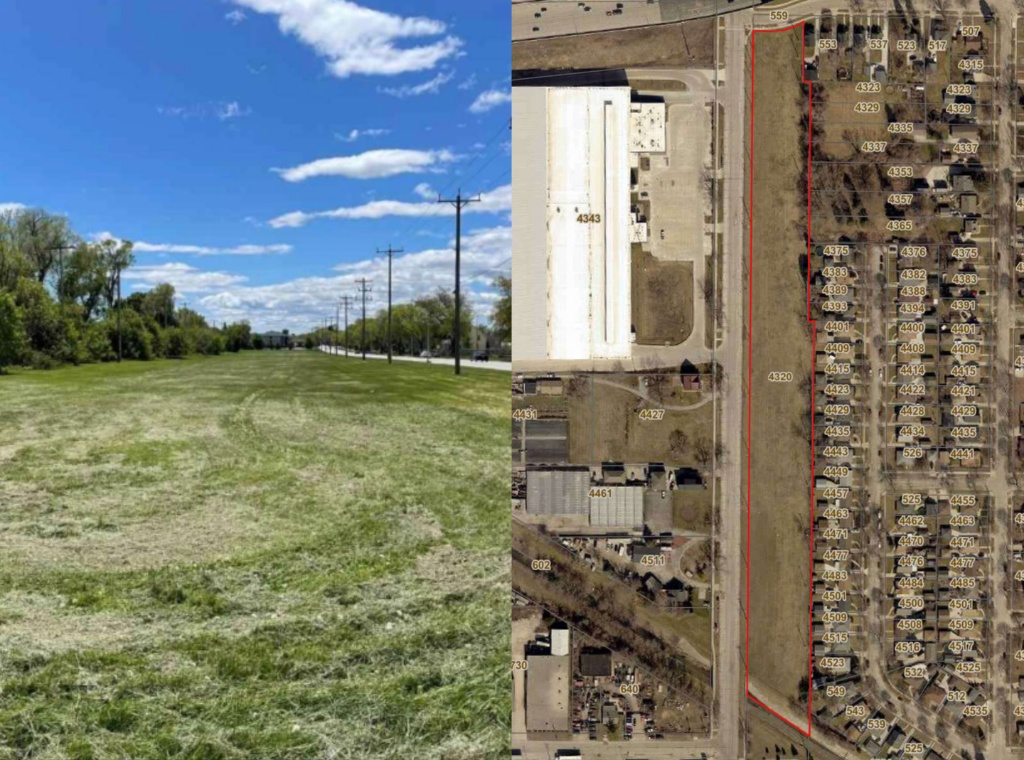
4320 S. 6th St. Photo and map by Milwaukee County.
Milwaukee County is soliciting proposals for a 5.4-acre strip of land it owns on the south side of the city of Milwaukee and is hoping for affordable townhomes.
The parcel sits at 4320 S. 6th St., near W. Layton Avenue and Milwaukee Mitchell International Airport. It is bounded on the north end by W. Bolivar Avenue and, beyond that, Interstate 43/94. Wilson Park Creek runs along the south end of the parcel, forming a southern border and separating it from nearby commercial properties.
The land was previously used by the Chicago, North Shore and Milwaukee Railroad, commonly known as the North Shore Line, which ran between the two cities. The line was shut down in 1963.
The county recently put the property out to bid for acquisition and development. It is looking for housing proposals. Affordable housing is encouraged, as are townhomes or so-called “missing middle” housing developments that provide housing options other than single-family homes or large multiunit apartment buildings.
In 2024, the City of Milwaukee reformed its zoning code to allow more “missing middle” development. The plan, originally called Growing MKE, was pushed by Mayor Cavalier Johnson as an effort to encourage more affordable, medium-density housing development across the city.
The parcel on S. 6th Street is already zoned RT4, which is the city’s most common zoning designation. It allows the development of one-to-four-unit buildings.
The site is part of 6th Street’s “Green Corridor,” which runs for three miles between W. Howard Avenue and W. College Avenue. It was designated in 2011 by the city. The corridor contains green infrastructure and community gardens. The county is looking for future development to incorporate green infrastructure and environmentally sustainable design in line with the rest of the corridor.
A future developer will also need to consider the local environment, as the southern end of the parcel lies within the floodplain of Wilson Creek. The channel runs underneath S. 6th Street just north of its intersection with W. Armour Avenue.
The creek is currently lined with concrete. In the middle of the 20th century, streams in the area were turned into concrete channels to move stormwater out of the watershed and into Lake Michigan as fast as possible with the goal of reducing flooding.
But heavy rains, which are more common today, create flows that are too large and fast for the channels, leading to flooding at bottlenecks. They also create dangerously fast currents that have taken the lives of residents. The Milwaukee Metropolitan Sewerage District (MMSD) is engaged in a long-term effort to remove concrete channels and naturalize the streambeds wherever possible, allowing creeks and streams to naturally swell and spread out during rain events without flooding homes or developing dangerous currents.
MMSD is working on removing the concrete from Wilson Creek, and the section running past the site on S. 6th Street is targeted for eventual removal.
The county will accept and review proposals for the site on a rolling deadline every three months beginning in September.
Legislation Link - Urban Milwaukee members see direct links to legislation mentioned in this article. Join today

Existing members must be signed in to see the interactive map. Sign in.
If you think stories like this are important, become a member of Urban Milwaukee and help support real, independent journalism. Plus you get some cool added benefits.
MKE County
-
Sheridan Park Bluffs Are Crumbling Away
 Jun 23rd, 2026 by Graham Kilmer
-
New Budget Director Faces Pushback in Second Hearing
 Jun 19th, 2026 by Graham Kilmer
-
Sentencing Scheduled for Hannah Dugan
 Jun 19th, 2026 by Graham Kilmer