
County Plans New Oak Creek Subdivision
County would subdivide about 20 acres of vacant land for residential development.
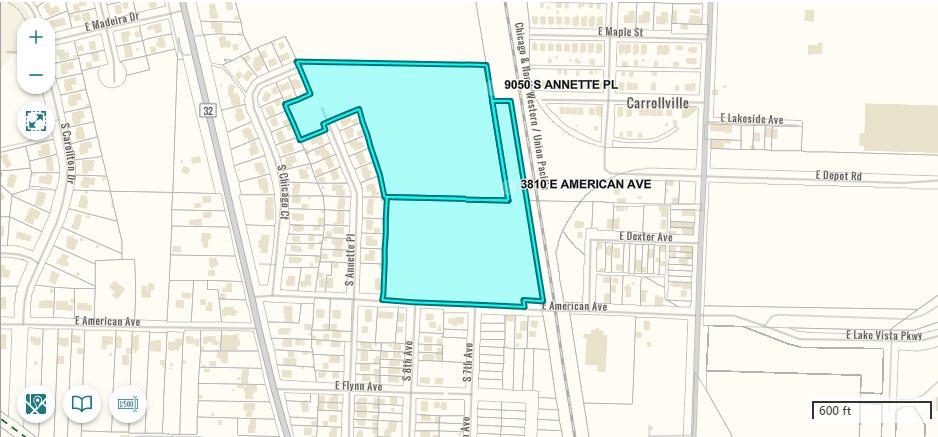
Map of proposed subdivision site in Oak Creek. Milwaukee County.
Milwaukee County is planning to turn approximately 20 acres of vacant land in Oak Creek into new housing.
The county’s Department of Administrative Services (DAS) solicited consultants in April to assist with planning, design and construction documents for a new subdivision.
The land in question sits between E. Puetz Rd. and E. American Avenue and is bordered on its eastern edge by a Union Pacific rail line. Just to the west of the land sits two existing subdivisions along Annette Place and S. Chicago Court.
The land is made up of two parcels that came into the county’s possession through tax delinquency in 2011. The two parcels are to be combined into one site and subdivided into as many lots as possible. Under City of Oak Creek zoning code, a 20-acre site could yield approximately 80 to 100 lots of 8,000 to 10,000 feet each, according to DAS.
“Historically, the Site was undeveloped agricultural land, with some residential development to the south of American Ave and to the west,” according to a 2018 report by The Reese Group on an environmental site assessment.
The land is not zoned as parkland, nor held and maintained by the county as parkland. Thus, the county administration can sell or develop the land without approval from the county board, which does not have authority over non-park county-owned land.
Contaminated Soil and Groundwater
Prior to the Reese Group assessment, there have been five separate environmental assessments and investigations at the site since 1993, all undertaken on behalf of parties interested in developing the site.
There is an area of the site with soil contamination that needs to be remediated. “Previous environmental reports have documented extensive excavation and fill activities throughout the 1960s and 1970s at the Site and neighboring parcels adjacent to the cul-de-sac on South Annette Place,” according to the Reese report.
In the northwestern corner of the site, adjacent to two vacant cul-de-sacs at the end of Annette Place and E. Briandean Ct., soil and groundwater contamination was discovered in 1996 during a site investigation by Midwest Engineering Services, Inc. and TN & Associates, Inc.
the source of the contamination was caused by fill material dumped at the site. “The fill material was characterized as metal debris, building and construction debris, asphalt and tar paper, cinders, possible paint residues, and foundry-related items (foundry sand, castings, and slabs).”
Reese performed two soil borings and installed two temporary groundwater wells for their own investigation, and concluded that, other than the known site of contamination, there were no contaminants on the property exceeding regulatory standards.
Wetland Delineation
Oak Creek has ordered a wetland delineation to be performed at the site prior to development, as there are a number of “wetland class areas” on the site, according to a map created by the county’s Land Information Office. An official wetland delineation is required for all projects that may impact wetland areas.
“A wetland delineation is a precise wetland boundary survey that meets federal and state regulations and is completed by a wetland professional,” according to the Wisconsin Department of Natural Resources.
UPDATE: An earlier version of this article named a predecessor to Union Pacific
MKE County
-
Pyrotechnics Being Added To July 3 Drone Show
 Apr 9th, 2026 by Graham Kilmer
-
See Designs for New Courthouse
 Apr 9th, 2026 by Graham Kilmer
-
Incumbents Sweep County Board Elections
 Apr 7th, 2026 by Graham Kilmer