City Wants Feedback on KK River Trails
Proposal would link two off-road trail segments, create corridor from South Side to Downtown
The Department of Public Works is starting the design process to create a link between the two off-road segments of the Kinnickinnic River Trail and improve the trail’s connection with other area trails. A website soliciting feedback on the corridors to be improved is now live.
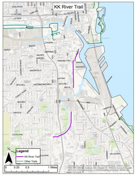
The current northern leg in Walker’s Point runs from E. Maple St. to E. Washington St. along the Canadian Pacific rail line. The southern leg in the Bay View and Polonia neighborhoods runs on a former railroad corridor from E. Lincoln Ave. near S. 1st St. southwest to S. 6th St. and W. Rosedale Ave. A gap of 0.7 miles currently separates the two.
Funded by a 2020 state grant, the plan by DPW envisions a mix of protected bicycle lanes, traffic calming measures and other strategies, making on-street accommodations on approximately two miles of city streets that are intended to serve people of all ages and abilities. Construction would take place in late 2023 and early 2024.
Nearly simultaneously, the Milwaukee Metropolitan Sewerage District is working on a western extension of the trail along the Kinnickinnic River west from S. 6th St. to Pulaski Park at S. 16th St. That project is part of a larger flood management project that has resulted in the deconstruction of several houses located near the formerly concrete-channeled river.
“We are very excited about this project as it will provide greater options for people to bike to and from Downtown. It is one more component to creating a stronger network of pedestrian and bicycle infrastructure throughout the city of Milwaukee,” said interim Commissioner of Public Works Jerrel Kruschke in a statement.
DPW’s project calls for improvements in four areas: S. 1st St. between E. Lincoln Ave. and E. Maple St. that separates the two trail segments; S. Water St. from W. National Ave. to E. Pittsburgh Ave. and the Milwaukee River that connects the trail to the Historic Third Ward; E. Pittsburgh Ave. and W. Freshwater Way that connect the north-south corridor with the Hank Aaron State Trail and Reed Street Yards; and, much further west, S. 16th St. to the extended trail in Pulaski Park.
“Thoughtfully designed infrastructure for bicycles and pedestrians adds vitality and quality of life in Milwaukee. It promotes recreation and non-motorized travel for commuters and others,” said Mayor Cavalier Johnson in a statement. “In this case, we have the resources and support to significantly improve the Kinnickinnic River Trail, and that is good news for people throughout the city.”
The federal government, through a Congestion Mitigation and Air Quality (CMAQ) grant passed through the Wisconsin Department of Transportation, will pay for 80% of the project’s costs. The project’s total budget is $1,199,780 according to a 2020 council approval.
If you think stories like this are important, become a member of Urban Milwaukee and help support real, independent journalism. Plus you get some cool added benefits.
Transportation
-
Congestion Pricing Cuts Air Pollution in New York City
 Dec 14th, 2025 by Jeff Wood
-
FTA Tells Milwaukee to Crack Down on Fare Evasion — Even Where Fares Don’t Exist
 Dec 12th, 2025 by Graham Kilmer
-
Will GOGO’s Bus Service Ever Get Going?
 Dec 9th, 2025 by Jeramey Jannene


It is great to see different governmental entities working towards developing a thoughtful option for downtown commuters which would also provide recreational opportunities of city residents. During Scott Walkers time as County Executive, he opposed putting bike racks on busses. The Republicans are a 2ist Century social and political version of the 18th Century Luddites.