Help Plan The Century City Park
MMSD solicits feedback for new park near 35th and Capitol that could emphasize play, nature or gathering.
The Milwaukee Metropolitan Sewerage District (MMSD) would like community feedback on how to develop a new, 10-acre green space in Century City.
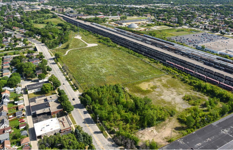
Known as the West Basin, the project is intended to capture 31 million gallons of stormwater during a storm as part of a strategy of reducing flooding of W. Capitol Dr. and the surrounding neighborhoods near N. 35th St. But a substantial publicly-accessible component is planned as part of redeveloping the former industrial site.
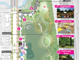
The site, 4220 N. 35th St., is bordered by Lincoln Creek to the north, the 30th Street Corridor rail line to the east, N. Hopkins St. to the south and N. 35th St. to the west. A 20-foot-deep basin, which would fill with water from rainstorms, is included at the core of each plan.
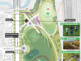
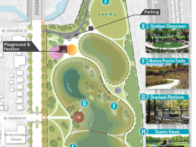
Trails would loop the basin. Two ponds, persistently full of water, are included in each design. Boardwalks would cross the basin at different points in each configuration.
The play plan includes a sledding hill, multi-sport field, pavilion and gateway sculpture. The nature plan includes a praire, playground with adjacent pavilion and outdoor classroom. The gathering plan includes an amphitheater, flexible plaza, picnic area, food truck marketplace and the most parking.
MMSD is now asking for feedback on which configuration people like most, and why. Individuals can respond to the survey on the MMSD website.
A virtual community meeting to discuss the project is scheduled for March 23 at 5:30 p.m.
The project is part of a broader strategy to address flooding in the area. Green Tech Station on the east side of the railroad corridor is already under construction.
A sewer is also being expanded. Located under W. Hopkins St., the project (MMSD NS12) includes the installation of an 84-inch diameter pipe and two underground stormwater structures.
A second sewer line is scheduled to be improved this year. Known as the MMSD Roosevelt SSO project, the 10-block-long proposal aims to prevent sewer overflows by redirecting the sanitary sewer system underneath W. Roosevelt Dr. The project is located on the edge of the combined sewer system that mixes stormwater runoff with sanitary sewer flows into the Deep Tunnel system and can trigger overflows, including at N. 35th St. and W. Roosevelt Dr., during large storm events. The proposal would prevent the sanitary sewer in the area from flowing into the combined sewer.
Together the plans amount to a 40-million gallon strategy to deal with stormwater runoff. They are being sequenced with other projects in the area as part of the 45-item Connecting the Corridor Action Plan.
West Basin Plans
Eyes on Milwaukee
-
Church, Cupid Partner On Affordable Housing
 Dec 4th, 2023 by Jeramey Jannene
-
Downtown Building Sells For Nearly Twice Its Assessed Value
 Nov 12th, 2023 by Jeramey Jannene
-
Immigration Office Moving To 310W Building
 Oct 25th, 2023 by Jeramey Jannene











The southern boundary is WEST Hopkins, not NORTH Hopkins. North Hopkins begins just north of Lincoln Creek and this project is entirely south of the Creek