
New Bike Trails and Ride Rules
A rundown of new bicycle amenities. And permits are now required for group rides on area trails.
I attended the recent Milwaukee County Trails Council meeting and once again have a lot to report. The meeting was attended by Melissa Cook, the WDNR Regional trail manager, SEWRPC, the WisDOT regional Bicycle and Pedestrian Coordinator, representatives from the Metro Mountain Bikers, representatives from the Rolling Dice Riders, and the Milwaukee County member of the Association of Wisconsin Snowmobile Clubs. Normally Kristin Bennett, the City of Milwaukee Bicycle and Pedestrian Coordinator, also attends, but she was at the Pro Walk, Pro Bike. Pro Place conference in Pittsburgh.
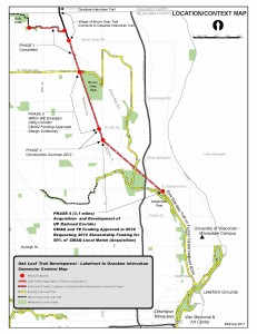
Oak Leaf Trail Extension North: As I reported in my last update from the previous Trails Council Meeting, phases 1-3 of this multi-year project are complete. Phase 4, AKA the UP Rail Corridor, is the final 3.1 mile link between where the trail currently ends in Estabrook Park and dumps you out onto Wilson, just south of Hampton Avenue, and the newest segment of trail that begins at Sydney Place. The segment includes four bridges.
Click the image for a larger view.
The staff from Milwaukee County Parks told us that their offer to purchase the right of way from the railroad went in last month. WisDOT has approved the Environmental Assessment and the Design Study Report, both formal parts of any state funded project. A revised acquisition plat was approved and filed with the County Clerk. DAAR Engineering, the WisDOT master consulting engineering firm hired to review every project in the SE Wisconsin region, is negotiating a three-party contract with Graef to be the bridge consultant.
Bottom line is they plan to advertise the project for bids by October 27th with construction in 2015. That assumes the bids come in OK, which is not a given since bids have been coming in high lately.
To anyone who has been riding the single track desire line trail for the last umpteen years, despite the trees growing up between the rails, that track was not officially abandoned until a few yeast ago, which explains why this has taken so long. The good news is there is finally light at the end of the tunnel!
Washed out Oak Leaf: The County was awarded FEMA money to repair some sections of trail washed out in the floods a couple years ago. Construction is done in the sections in Estabrook, Riverside, Bradford and Juneau Parks. Construction will start soon in Grant, Pleasant Valley, and Big Bay Parks.
We also discussed the river flooding and leaving mud on the trail in the underpass at Layton Avenue. Members noted that because of the very high water table there, the river floods pretty much every time it rains and leaves slippery mud on the trail that then dries into rutted concrete-like dirt. We discussed options and suggested a permanent sign warning trail users of the potential hazard and the need for increased maintenance. There is a marked at-grade crossing that people can use as an alternative.
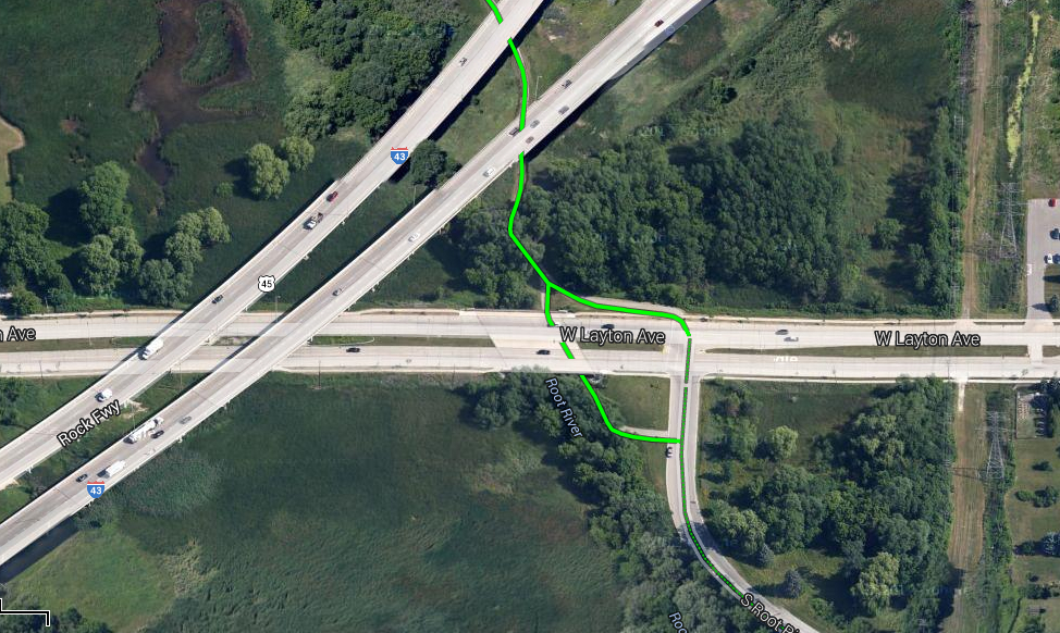
Click on the photo to visit a Google Map of the location. As you can see, there is a marked at-grade crossing on Layton that people can use as an alternative.
Menomonee River Parkway Reconstruction: The Wisconsin Bike Fed is part of the consulting team on this project. Our role is small, but important as we review bicycle and pedestrian accommodations. Anyone who has ridden on the Menomonee River Parkway knows it is in dire need of reconstruction. This project will include a separated multi-use path, better on-street accommodations for bicycles as well as rain gardens and bioswales to collect storm water runoff and cleanse it of silt and pollution. There also will be new LED lighting, improved pedestrian crossings and some minor traffic calming to keep motor vehicle speeds down and help reduce cut-through traffic. The overall goal of the project is to restore a parkway feel to the road, oh, and to fix the pot holes! The project has a website with more information here.
The project is being done in two phases, with phase one from Capitol to Burleigh and phase two from Burleigh to Church Street. The county has budgeted about $3.1 million for the first phase, which will cover about two miles of the parkway from Capitol Drive to Burleigh Street. A second phase would be funded in the 2015 budget, it includes another 2.5 miles of parkway from Burleigh Street to Church Street in the Village, likely to cost about $3.8 million.
Phase one of the project was advertised and bids were opened August 13th. They are waiting for a permit to be approved, but underground work will start this year and perhaps some road construction. The rest of the project will be done in 2015, it includes a new section of trail along with improved bicycle/pedestrian and storm water facilities on the parkway itself.
Beerline Trail Extension: The City has hired a consultant to begin acquisition of the abandoned railroad right of way needed to extend the Beerline Trail north from Keefe Avenue to Capitol Drive. The project will also include elements from The Artery.
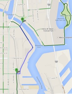
Click to open a Google Map of the final phase of the Bay View to Downtown Connector WisDOT Preferred Alternative.
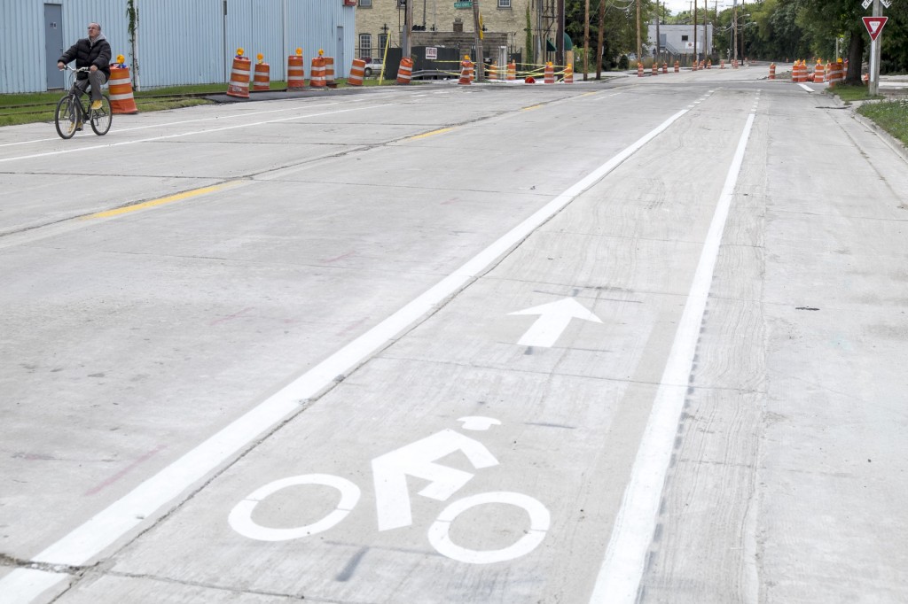
Bay View to Downtown Connector: How old do you have to be to remember this project began as a bike path over the Hoan Bridge? OK, I won’t go there, but I am happy to inform readers that construction on the final segment of the WisDOT Preferred Alternative for the Bay View to Downtown Connector is nearly complete. This segment begins where the Kinnickinnic River Trail ends at East Washington Street and is planned to continue north along S. Water Street to Erie. The project includes a combination of new pavement, removal of some abandoned railroad tracks, improved track crossings for the active rail lines that remain with a side path to get people over the oblique crossings at a safe angle, new bike lanes, and anti-slip plates on the Pittsburgh/Young Street bascule bridge over the river.
I rode down to check it out over the weekend and there were already people taking advantage of the new facilities. While it isn’t the Hoan, it does make for a better route from Bay View to Downtown. Check out my photos of the project below.
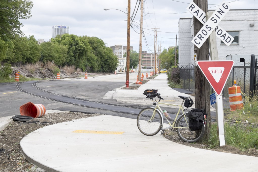
The side path along the east side of S. Water Street begins just north of Washington Street. here you can see how the City designed the crossing of the oblique railroad track to be at a safer angle. I remember red lining these plans when I still worked for the City!
New pavement and bike lanes on S. Water Street.
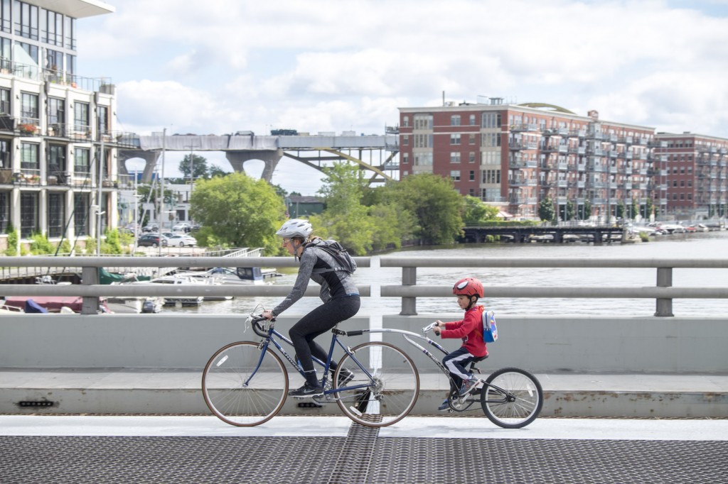
These riders are taking advantage of the new anti-slip plates on the metal grate lift bridge over the river, and ignoring the ironic view of the Hoan under construction in the background.
The City of Milwaukee also added green bike lanes in the conflict points when they resurfaced Humboldt Avenue. Humboldt is a very important bicycle route in Milwaukee and this project was greeted with celebration by the neighbors in Riverwest. They even organized a quick “green party,” in which people dressed in green pedaled over to promote the new green lanes.
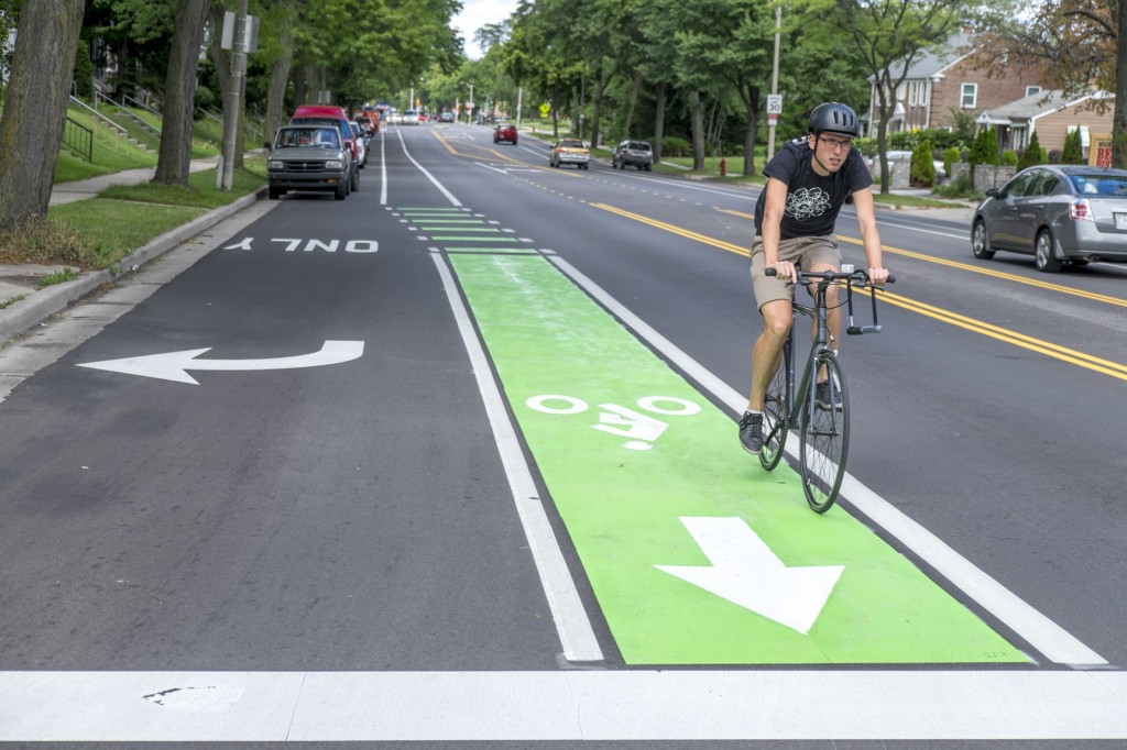
Green pavement markings in bike lanes can be used to highlight conflict points in mixing zones where motor vehicle and bicycle traffic cross.
Counting Bicycles: Milwaukee County was able to purchase a trail counter with funds raised by the Oak Leaf Trail Discovery Tour Passport Program. The County hopes to purchase 16 more counters next year. The Counter is already in place and sending in great data. Motor Vehicle counts are part of every state and municipal annual traffic program. Doing counts of people using trails should really be done everywhere too. Madison has been counting trail users for years and that data is very useful to see growth and know when to do maintenance on trails to impact the least amount of users.
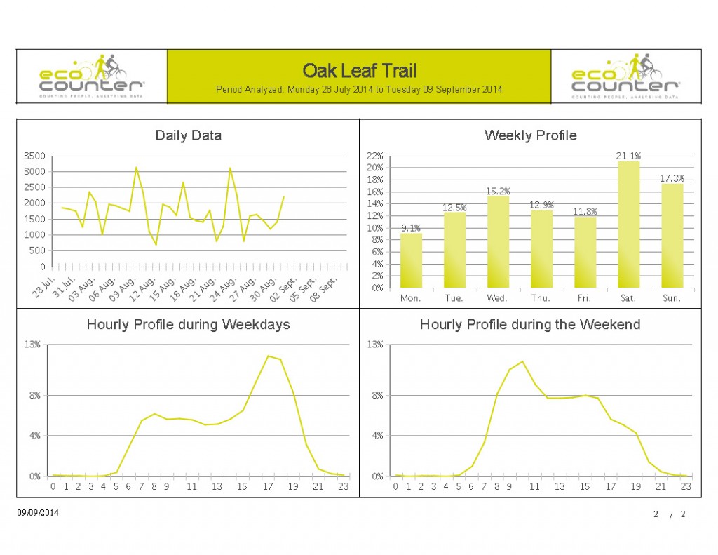
The new counter the County purchased sends the data via cellular connection to a website where it can be downloaded.
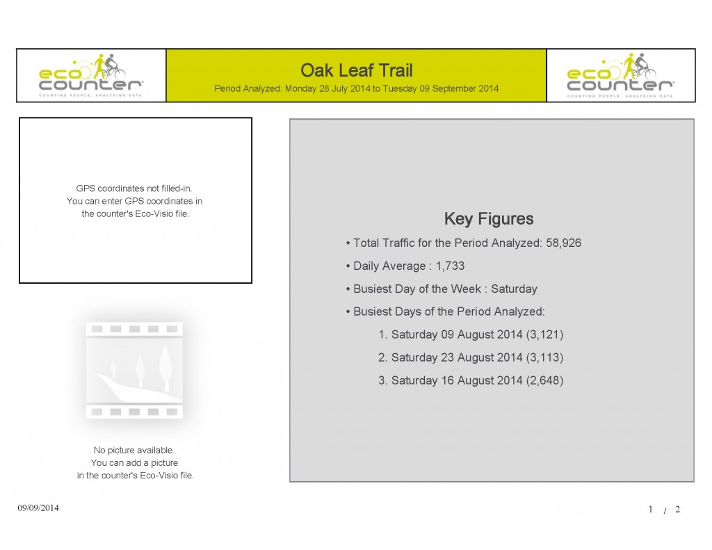
59,000 people used the trail during the period it was out. We will be able to compare that number in future years to see if use is growing. It will be very interesting to see if the numbers take a big jump after the final connection to the Interurban is completed in 2016.
The Bike Fed is using volunteers to do manual counts in the Riverwest and Harambe neighborhoods as part of the benchmarking part of our Smart Trips Project and we might try to expand those counts locations around the City next year.
Milwaukee Bike Maps: When I last spoke with City of Milwaukee Bicycle and Pedestrian Coordinator Kristin Bennett, she told me she had someone working on updating the GIS for a new map and was 90 percent sure she would have funding to reprint the map in 2015.
State Bike Map: The state is working on an update to the state map, they have asked if the Bike Fed would distribute the map again and pay for printing this time. It seems as if the company that previously printed and sold the map to us is no longer interested in printing maps. While digital maps are probably making it harder for for-profit companies to print maps, as a non-profit, we might be able to make that work, so we have agreed in principle, but no final details of that arrangement have been worked out. Unlike the Milwaukee County map, there remain many thousands of state bike maps available, so it is not as urgent.
Mountain Biking: The Metro Mountain Bikers are interested in revisiting the Memorandum of Understanding with Milwaukee County that defines their roll of building and maintaining mountain bike trails in the County. We are talking about the possibility of legitimizing the social trails that connect the official trails at Hoyt Park with the other set of official trails at Harley Woods and Oak Hill.Special Events Permits now required to hold events on trails and in parks: This topic might need a blog post of its own. Milwaukee County Parks and the WDNR are now requiring ANY publicized event (runs, rides, yoga classes, etc.) to be permitted. This means any time someone creates a Facebook Event for a bike ride that uses the Oak Leaf Trail or Hank Aaron State Trail they must fill out a permit, even if there is no fee for the ride (or run, yoga class, etc.).
Underwear Ride, Monthly Group Ride, team training ride, class field trip on bicycles, whatever, if you create and publicize an event and invite people to it using social media or regular media, you must get a permit. If no fee is being charged for the event, it is likely there will be no fee required for the permit. The state has an insurance requirement though, which will be very problematic for most free events.
Before you get up in arms (like I did when I first heard this), I would ask EVERYONE to fill out the permit applications for EVERY ride you publicize. Not for every ride you take on your own, but any event you create, or for every regular standing event. By doing so, this will do several things:
It will help the County get a better idea of just how many events are in the parks and how many people are really using the parks. That sort of information could be used to request additional funding and resources.
It will help ensure your event does not conflict with other events you might not know about.
It will also test this policy. Nobody has yet had a problem with it, so why complain yet? Let’s try it out, fill out the permit applications (they are not long) and see how it goes? If the state and county are able to quickly turn around and approve permits and this results in better data about users, it will be a win. If the process holds up ride planning, overwhelms staff resources, or free social rides are refused because of the insurance requirement, the Bike Fed can work with the agencies to get changes made in this policy.
Here is a link to the County permit application
Here is a link to the WDNR permit application
This article was originally published by the Bicycle Federation of Wisconsin.
Bike Czar
-
Join a Bike Ride Under the Polish Moon
 Jun 1st, 2018 by Dave Schlabowske
-
9 Reasons to Join National Bike Challenge
 May 4th, 2018 by Dave Schlabowske
-
Biking Through the Mindoro Cut
 Apr 27th, 2018 by Dave Schlabowske


All great news for the Milwaukee cycling community! One comment I have is regarding the “green”mixed zone lanes. Will painting these wide green swaths create slick areas on the asphalt when wet making those areas less safe?
Hey Alan,
No, the thermoplastic used has material in it so it is not slippery.