EnglishEspañolDeutschБългарски
Follow Urban Milwaukee on Twitter Like Urban Milwaukee on Facebook Subscribe to Urban Milwaukee via email Subscribe to Urban Milwaukee via RSS

MCTS Announces MetroEXpress – GreenLine, BlueLine, RedLine

Nov 30th, 2011 | By | Category: Feature, MCTS

MCTS will use existing buses to service the new routes

The Milwaukee County Transit System has unveiled a name for the new express service, and for the three new express routes. The express service will be known as MetroEXpress, and will begin service January 29th, 2012.

The Bayshore to Airport express service will be known as GreenEXpress GreenLine. The Fond du Lac – National express service will be branded BlueEXpress BlueLine. The Capitol Drive express service will be known as RedEXpress RedLine.

The final routes will follow closely what was initially proposed in the face of the substantial state funding reduction (and the CMAQ funded two-year bailout).

The new service will operate with existing MCTS buses, and does not include any vehicle branding at this point beyond the name being digitally displayed on the signage. Service will stop approximately every 1/4 of a mile, compared to the current 1/8 mile standard MCTS service follows.

In addition to the new service, MCTS is restructuring a number of other routes, and adding a handful of new routes. All of the details can be found in the links above, which point to PDF maps of each of the new routes.

Of note compared to prior maps of the routes, MCTS has changed the new route 56 (replacing much of Routes 11 and 18). Instead of continuing straight west on W. Greenfield Avenue from 1st to 124th, the route will turn south on the Miller Park Way, where service was previously proposed to be discontinued. It will follow Miller Park Way to Burnham Street, and Burnham to 60th Street, where it will head north to rejoin Greenfield Avenue.

In addition, the northern end of the new Route 52 (servicing a branch of Route 15) has been extended with the route continuing north to Mitchell Street instead of terminating at Lincoln Avenue and Kinnickinnic Avenue.

As noted in a previous article, this new service will not cost any more than existing service to ride.

For a much greater background on the new express service, MetroEXpress, please see our previous article “Introducing the Bayshore – Airport Express Bus Service“. MCTS has also published a page containing information on the upcoming service changes.

UPDATE: I left out information on headways and service hours when I originally published this article, they will begin as follows.

RedEXpress (Capitol Drive)

  • Service will operate roughly 4:30 am to 12:30 am, seven days a week
  • Frequency – Weekday: 15-20 minutes, Saturday: 25-30 minutes & Sunday: 25-30 minutes

BlueEXpress (Fond du Lac-National)

  • Service will operate roughly 4:30 am to 2:00 am, seven days a week
  • Frequency – Weekday: 15-30 minutes, Saturday: 30-45 minutes & Sunday: 30-45 minutes

GreenEXpress (Bayshore-Airport)

  • Service will operate roughly 4:30 am to 2:00 am, seven days a week
  • Frequency – Weekday: 10-15 minutes, Saturday: 20-25 minutes & Sunday: 25-30 minutes

RedEXpress & Route 62 combined frequency

  • Weekday: 15-20 minutes; Saturday: 10-15 minutes & Sunday: 10-20 minutes

BlueEXpress & Route 23 combined frequency

  • Weekday: 10-15 minutes; Saturday 15-20 minute & Sunday 15-20

 UPDATE 2: I have been notified by MCTS that the individual lines will be updated to be known as the GreenLine, BlueLine, and RedLine.


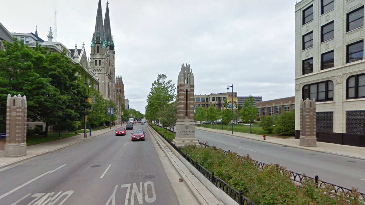
Close Wisconsin Avenue Through the Marquette Campus?

Nov 28th, 2011 | By | Category: Avenues West, Feature, Marquette, MCTS, Roads & Highways

In 1992, Marquette proposed closing Wisconsin Avenue to vehicular traffic between North 11th and North 16th streets, as well as one-block sections of North 12th and North 13th streets between Wisconsin Avenue and Wells Street. The project was called Avenue Commons and the intent was to create a pedestrian mall in the reclaimed roadway. At the time, Wisconsin Avenue was three-lanes in each direction and Marquette was a school in flux with financial challenges and a perception of having an unsafe campus. Closing a section of Wisconsin Avenue was intended to make the campus safer and more attractive, and the closing would have had a big impact on the university and city, but would it have been positive?

Wisconsin Avenue Today from Google Maps

Wisconsin Avenue Today from Google Maps

Today, Wisconsin Avenue includes two lanes in each direction as it crosses the Marquette University campus. In addition, it includes wide sidewalks, a sizable, attractively landscaped median complete with Marquette branding, and curb space for bus stops and parking. At the time of the proposal, Wisconsin Avenue had three lanes of traffic in each direction, which enabled traffic to speed through the Marquette campus. It also lacked the wider sidewalks, and only had a small median complete with run-of-the-mill street lights. It was far from a grand avenue, and did little to make the campus seem worthy of one’s attention. Wells and State streets were also a one-way street at the time (they were converted to two-way traffic from 11th to 27th streets in 2004), further painting the campus as a mere pass-through on the way in-and-out of downtown.

In April of 1994 at the direction of the Common Council, the City Engineer coordinated a study (see: Footnote 1) of the impacts of the proposed closures, primarily on the existing transportation system. The report contains three alternatives for handling the displaced traffic, No Build, Alternate Route, and Tunnel. Ultimately, the Common Council adopted none of these plans, but for the sake of debate let’s examine them.

Background

The study includes a large amount of data, the most important of which I have attempted to include  in the scanned images shown below in the photo gallery. Of note, the closure of Wisconsin Avenue would have not only directly impact more than 22,000 vehicles per day that used the very stretch at that time, but 1,081 bus trips, totaling 17% of MCTS’s total buses in operation at the time, and approximately 22,000 daily riders.

Given the odd path the proposal took through the Common Council, and how divided the community was on the issue, there are a substantial number of articles available in the Google News archives about the topic.

Of interest, at one point covering Interstate 43 with a plaza was discussed as part of the plan. Something we’ve discussed in the past.

No Build

The No Build alternative was merely that. Close the streets to vehicular traffic at a cost of $212,000, and not provide a new thoroughfare. Buses were anticipated to be rerouted down to Clybourn Street, with an anticipated loss of 416,300 rides a year for an annual impact of $1,109,100 to MCTS. The City was expected to lose $58,600 annually. Most significant, traffic was expected to climb on Wells Street by over 30%, and on Clybourn St by nearly 60%.

This option clearly would have been the cheapest when considering the capital costs of implementing it, but it likely would have produced highly undesirable results. The additional roadways would have seen a significant increase in traffic, which would have made them nearly as bad to cross as Wisconsin Avenue was at the time (and arguably defeated the purpose of the closure). In addition, the closures would have made it more difficult to access the campus, especially given that there was no plan to convert Wells Street to two-way traffic with this alternative. Confusion to general motorists as to why a street abruptly terminated would have been a persistent cause of backups.

Tunnel

Wisconsin Avenue Tunnel

The proposed Wisconsin Avenue tunnel with the closed Wisconsin Avenue above.

I can’t imagine a tunnel was ever a serious consideration, and digging through the archives of the Journal and Sentinel seem to confirm this. Never the less, the plan called for $30,070,000 to be expended for the construction of the tunnel as well as sewer and water infrastructure relocation. Not budgeted was relocation of utilities from the Wisconsin Gas Company, Wisconsin Electric Power Company, and Ameritech. Who would have been liable for the utility relocation if the tunnel was built? Your guess is as good as mine, but it bears a bit of similarity to the current debate over the utilities and the Milwaukee Streetcar, as well as a major road project that occurred next door and required millions in utility relocation expenses, the Marquette Interchange. While providing a vehicle-free street to those above, the tunnel was expected to cost the City $46,400 annually in lost revenue and operating/maintenance costs, as well as having caused MCTS to lose 93,275 rides a year for an annual impact of $176,550.

Why this option was studied is unclear, because I can’t imagine a single scenario where Marquette, the City of Milwaukee, or the State of Wisconsin would have paid for this. Ironically, there were formerly tunnels under Wisconsin Avenue, but they were for pedestrians. They were in place from the 1930′s to the early 1970′s and were ultimately closed because of safety concerns.

While this option may have had the smallest impact on the city as a whole by still allowing traffic to flow in a near grid-like fashion through the area, I think it ultimately may have impeded access to the center of Marquette’s campus by forcing those coming by car, bus, or, at the time proposed, light rail to enter from the outside, instead of allowing street grid access to the heart of the campus today. All that in addition to the fact that the money just wasn’t there for this option.

Alternate Route

Long Diagonal Connector - Recommend Alternative

Long Diagonal Connector - Recommend Alternative

Multiple alternate routing options were studied, including a busway along Wells Street and a Short Diagonal Connector. Given that the Long Diagonal Connector with a two-way Wells Street was the recommendation of the study I will stick with discussing that. The Long Diagonal Connector was recommended because it had the smallest impact on traffic of all of the options proposed, while actually staying financially feasible, unlike the tunnel.

The Long Diagonal Connector would have pleased motorists greatly over the no-build option. It would have included the acquisition of property for a new roadway that connected West Wisconsin Avenue with Clybourn Street between 16th and 18th streets, allowing smooth access around the campus. It seems likely there would have be a great amount of political pressure applied to ensure this proposed road would be as free-flowing as possible, which in the long-run would have made Marquette seem like an island in the city by discouraging development facing it.

An additional part of the recommendation was to convert Wells Street into a two-way street from 10th or 11th to 16th or 17th streets, something that ultimately would not happen until State and Wells were both converted in 2004.

The diagonal street would have required the acquisition and demolition of buildings and parking lots, removing them from the tax-base, and no doubt influencing how and where Marquette has developed many of its recent campus additions.

The cost to build the Long Diagonal Connector and Two-Way Wells Street was estimated to be $9,840,000, with annual costs to the city of $82,900. The annual impact to MCTS was estimated to be $777,200, with a loss of 209,150 rides.

Conclusion

It’s easy to understand how the closure of Wisconsin Avenue might have seemed logical on the surface in the early 1990′s (see: Footnote 2). Wisconsin Avenue was a six-lane road, the university was struggling, the stigma of Dahmer hung over the campus (and city), Wells and State were one-way highways, and many of the new buildings along Wisconsin Avenue weren’t even on the drawing boards (Zilber Hall, Engineering Hall, the Blood Center, etc., etc.). Wisconsin Avenue was essentially a surface highway through the Marquette campus.

The proposal was sent back and forth from the full Common Council to committee multiple times, ultimately failing. At one point then-Mayor John Norquist offered his input publicly on the issue, but although his suggestions mirror how the configuration is today, even his suggestions were ignored for years.

The Avenue Commons proposal came down to one alderman in the end, with southside Alderman Robert Anderson changing his likely vote from a yes (which he voted in committee) to a no. He did so apparently at the suggestion of his wife, which angered some in the community. I’m pretty certain Anderson didn’t envision Wisconsin Avenue and Marquette interacting as they do today, but his change of heart has led to Marquette becoming a school that is well integrated into the city, and a far greater asset than it was before the proposal.

Street closures are generally a bad idea, the street grid exists to provide predictable, easy transportation for all vehicle types. Cutting off one piece not only makes that area harder to access, but increases stress on other areas of the grid. Couple that overarching philosophy with the street grids challenges near Marquette, including the vast amount of one-way streets, a number of abruptly terminating streets because of the hospital and campus, and the overwhelming barrier Interstates 43 and 94 create (and the lack of bridges that cross them), and it’s clear that closing that small stretch of Wisconsin Avenue would have seriously impeded the flow of thousands of bus riders and drivers.

It took time, until the Marquette University Campus Identity and Beautification was executed in the early 2000′s, but Marquette eventually got it right. Wisconsin Avenue is now the front-door to the campus, and an asset to the city. The street has been tweaked ever so slightly to remove a driving lane and calm traffic, streetscaping in the median has made clearly defined areas for pedestrian crossing making it safer for pedestrians and drivers, and signage has been installed to proclaim to all who cross that you are entering the Marquette campus, or rather “We Are. Marquette.

Footnote 1 – For those interested, this report can be found at the Milwaukee Public Library. It is titled “Proposed West Wisconsin Avenue Closure – Feasibility, Cost, and Neighborhood Impact Report”. Some of the more wonk-ish reading you will ever do, but you might find it enjoyable. The scans presented in this article are from it.

Footnote 2 – The Milwaukee Sentinel (prior to the merger with the Journal) Editorial Board wrote a number of editorials endorsing the plan. They include (but aren’t limited to) editorials on April 18th, 1994June 23rd, 1994, August 17th, 1994


Reed Street Yards Redevelopment Funds Approved at Committee

Nov 28th, 2011 | By | Category: Feature, Hank Aaron State Trail, Riverwalk, Walker's Point, Zoning, Neighborhoods & Development Committee
Reed Street Yards Site Plan

Reed Street Yards Site Plan

At the November 22nd, 2011  meeting of the Zoning, Neighborhoods & Development Committee funds for the construction of new infrastructure within the Reed Street Yards were approved.   The 17-acre property, known as the Reed Street Yards, is located between South 6th Street and South 3rd Street, and has been targeted by the City of Milwaukee and the Water Council as the future center of Milwaukee’s water industry.  The project will be broken into two phases and include the construction of public improvements such as the $3.6 million extension of Pittsburgh Ave., new water mains, new sewer connections, 2,700 feet of Riverwalk, an extension of the Hank Aaron State Trail, 300 feet of dock wall that is in need of being repaired, and site remediation.

The financing for this project comes from TID #75, which was created in 2009 for this very purpose.  The funds to payback the TIF, will be generated through the redevelopment of a 88,000 square foot warehouse at 3rd St. and Pittsburgh Ave.  This building will become the home of the Water Council, and will house research facilities for Badger Meter and A. O. Smith, a $500,000 lab paid for by Badger Meter that will be available for tenants use, space for startup water businesses, a Viola water, energy, and transportation accelerator, UWM’s School of Freshwater Sciences, and a multitude of other entities in the water field.  According to Dean Amhaus, Water Council Executive Director, this combination of public-private partnership, in combination with startup space and the lab will make the this a “one of a kind building, from a global standpoint”.


Weekly Bookmarks – Monday, 28. November 2011

Nov 28th, 2011 | By | Category: Bookmarks


Friday Photos Friday, 25. November 2011

Nov 25th, 2011 | By | Category: Friday Photos

Beerline B Apartments & The Moderne in the Distance

Beerline B Apartments & The Moderne in the Distance

Beerline B Apartments

Beerline B Apartments

1910 on Water

1910 on Water

1910 on Water

1910 on Water 2

The Moderne

The Moderne


Is WisDOT Inflating Traffic Counts in the Hoan Bridge Bicycle Study?

Nov 21st, 2011 | By | Category: Feature, WisDOT

The Hoan Bridge as seen from the US Bank Center top floor.

Last week, the Wisconsin Department of Transportation (WisDOT) gave a presentation regarding the possibility of adding a bike trail on the Hoan Bridge.  The DOT laid out five potential alternatives, that covered a wide range of costs, and potential impacts such as traffic congestion.

The cheapest option, the $9.4 million version known as Alternative 1A, was clearly the concept on the minds of supporters, because it was the most affordable and realistic of the designs.  But the WisDOT report gave this option a ‘level of service’ rating (LOS) of F, likely ruling it out as a viable option in the eyes of WisDOT.   When WisDOT talks ‘level of service’ they are determining the level of traffic congestion, which is measured by the density of traffic and traffic flow, or speed.  I’m not a traffic engineer, but this ‘level of service’ determination by WisDOT seemed to come to an odd conclusion, and was made using flawed, and even conflicting, assumptions.

In this case, the level of service F grade, as a result of the trail’s construction and lane removal, is predicted to occur in 25 years, for one hour a day, and will result in traffic speeds dropping.  According to the report, today normal traffic operation on the bridge is actually speeding.  In 25 years?  For one hour a day, speeds are projected to drop to 47 mph on the bridge segment while still allowing speeds of up to 54 mph on the ramps.  In fact, the two-lane design will still allow for people to speed across the entire bridge during the vast majority of the day, and on the ramps during rush hour.  Certainly designing any road for speeding should get an F rating, but that’s not the argument here, as WisDOT rates this an F because they assume a free flowing traffic speed of 60 MPH. Their assumption is that driving 10 mph over the speed limit is the ideal operational state for the bridge.  No doubt an odd conclusion. The F grade indicates impending carmageddon, but in reality is merely a projection that people will have to drive near the speed limit for one hour a day.

It also appears the projections are based on flawed assumptions.  In their report, WisDOT makes the assumption, not an actual measurement, that “From this set of historic traffic pattern data it can be concluded that the current weekday traffic volume on the Hoan Bridge, without the current maintenance lane closure impact on traffic, is 48,200 vpd (vehicles per day).”  Essentially, WisDOT is estimating that 12% (6,400 vpd) of the traffic on the Hoan Bridge is currently being diverted to other roads due to lane closures for construction.  While this assumption seems somewhat out of line when compared to recent traffic counts (for example 2010 where the count was 42,900 vpd), this isn’t the only issue with this assumption.  The report makes another assumption, contrary to this one.

“The capacity analysis does not assume any traffic diversion to other routes that could result from a permanent capacity constrained 2-lane condition to accommodate a shared-use path on the Hoan Bridge.”   In other words, when predicting the future congestion levels for design 1A, WisDOT makes the projections based on the three lanes of travel, and ignores the likely possibility of permanent traffic diversion due to a permanent lane reduction (that the 12% they estimate is diverted currently would stay diverted).  The idea that traffic will divert for construction, but not for a permanent lane reduction is questionable, if not contradictory, and calls into question all of the future traffic projections.

Remember that just a few years ago, WisDOT released a document considering replacing the Hoan Bridge with surface level bridges.

Our hope is that WisDOT re-evaluates the traffic projections based on actual traffic counts, and proceeds with Alternative 1A.


Weekly Bookmarks – Monday, 21. November 2011

Nov 21st, 2011 | By | Category: Bookmarks


Food for Thought: New Recipes for Job Growth

Nov 19th, 2011 | By | Category: City of Milwaukee, Feature, Neighborhoods
Market

Market

Now that the season for indulgence is upon us, it is a good time to explore how food impacts our communities. In light of the current economic downturn, it is important to seek opportunities for job growth in new and expanding business sectors.  In southeastern Wisconsin, opportunities within the local food economy are rapidly expanding.  Food manufacturing, distribution and urban agriculture are major employers and are continuing to grow and evolve.  It’s imperative that we need to take notice if we are to capitalize on their economic development and job-growth potential.

For the past 10 years, the Urban Economic Development Association (UEDA) has hosted its Community Development Summit, focusing on various topics that impact the economic climate in southeastern Wisconsin.  This year, on November 29th, the Summit will issue a call-to-action to southeastern Wisconsin, to come together and develop a plan of action to ensure that our region, and most notably our urban communities, builds upon the growth of this industry and commits to working toward enhancing the economic potential of the food sector.  As additional advancements and investments are made in this sector, the greater Milwaukee region needs ensure that we are at the table to bring jobs and economic development related to this industry’s growth back to our communities.

As a region, we must come together to create an environment that will produce opportunities for job growth in the food sector.  As a community, we need to take advantage of every opportunity to create local jobs that benefit our communities. Food manufacturing and urban agriculture not only create local jobs, they often connect low-income neighborhoods with fresh, locally-produced, healthful food options.

For event information please click here.

Guest post by: Bill Johnson Sr, Executive Director, Urban Economic Development Association of Wisconsin, Inc. (UEDA)


Friday Photos Friday, 18. November 2011

Nov 18th, 2011 | By | Category: Friday Photos

Future Home of Milwaukee Bicycle Works

Future Home of Milwaukee Bicycle Works

UMCS Phase III

UMCS Phase III.

UMCS Phase III

UMCS Phase III

UMCS Phase III Groundbreaking

UMCS Phase III Groundbreaking

UMCS Phase III

UMCS Phase III..


Milwaukee Streetcar Hearing at Frontier Airlines Center

Nov 15th, 2011 | By | Category: Feature, Milwaukee Streetcar

The streetcar as it meets Broadway in the Third Ward.

On Wednesday, November 16th, from 5:30 p.m. to 8:00, there will be a Public Hearing on the Draft Environmental Assessment Document for the Milwaukee Streetcar. During this meeting attendees will be able to provide a comment on the record regarding the Milwaukee Streetcar project. The meeting is being held at the Frontier Airlines Center on Wisconsin Avenue.

A formal presentation on the document begins at 6:00 p.m.

A public notice for the hearing can be found at MilwaukeeStreetcar.com.

The draft Environmental Assessment document is available in PDF format.

UrbanMilwaukee.com has long supported the Milwaukee Streetcar Project, and hopes the public comes out to show their support for this project.