
County Has A Year To Cap Landfill It’s Struggled to Sell
DNR says action required on Greenfield property acquired via property tax foreclosure.
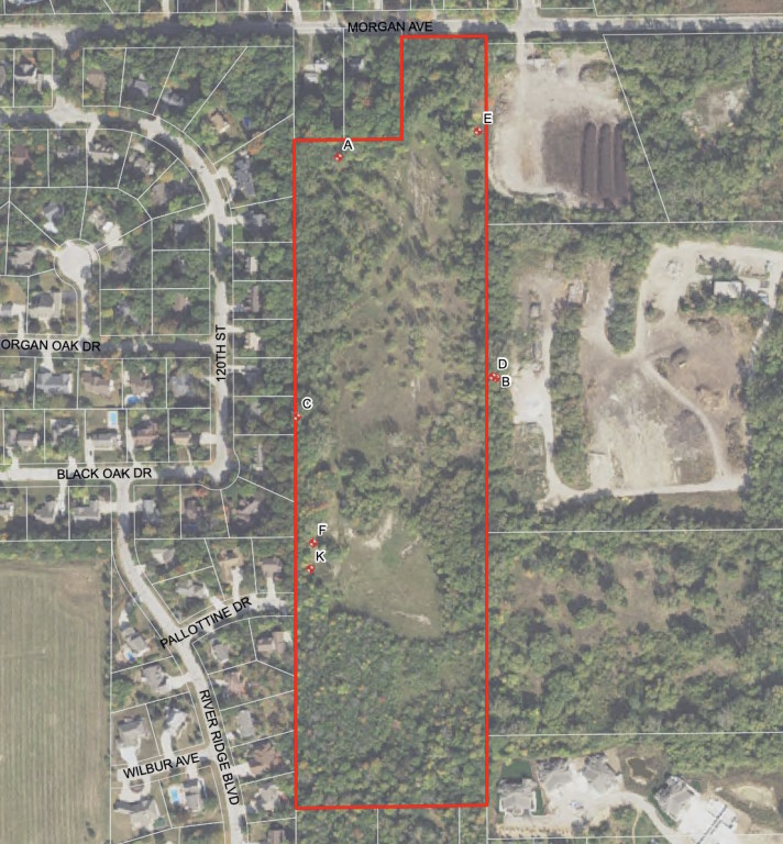
Site map for former Allis-Chalmers Landfill. The Reese Group.
The Wisconsin Department of Natural Resources (DNR) has given the county until the end of 2025 to cover a former landfill in Greenfield.
The property is a 19.6-acre site at 11815 W. Morgan Ave. It was used as a gravel mine until 1964 by Price Sand & Gravel. Allis-Chalmers, the former industrial machinery manufacturer, used the site as a dump for foundry sand.
Milwaukee County took control of the former landfill through property tax foreclosure in 2015 from Cuywreco, Inc., which bought the property in 1998. The county has spent the past year marketing the property for sale. However, without a buyer, the county will have to pay to cap the landfill properly by the end of 2025, per DNR regulations.
County Executive David Crowley‘s 2025 recommended budget includes approximately $1.5 million to close out the site, which includes constructing a final cap over the waste areas, grading for proper drainage, planting vegetation and erosion control measures.
In 2018, the DNR inspected the site and found it out of compliance with state regulations for landfills. Under state law, the DNR can ask the state Department of Justice to seek financial penalties between $10 and $5,000 per day against violators of the regulations. The DNR has given the county time to try to sell the property, but without a buyer the county has until Dec. 31, 2025 to bring the county into compliance, according to Crowley’s budget recommendation.
The county still has the land for sale, and will close bidding at the end of October. The site is bordered on the west by a subdivision and to the east by S. 116th Street and, beyond that, the Root River.
In the past, testing of ground water samples at the site have detected several volatile organic compounds, which are common groundwater contaminants that vaporize easily; heavy metals like lead and arsenic; and other materials.
In 2002, engineers from GRAEF determined there is 28.5 feet of foundry sand buried in some parts of the site, though in most areas the depth rises to only 15 feet. Foundry sand is used to create molds for metal castings. It’s considered hazardous waste when dumped.

Existing members must be signed in to see the interactive map. Sign in.
If you think stories like this are important, become a member of Urban Milwaukee and help support real, independent journalism. Plus you get some cool added benefits.
More about the 2024 Milwaukee County Budget
- MKE County: County Has A Year To Cap Landfill It’s Struggled to Sell - Graham Kilmer - Oct 4th, 2024
- MKE County: County Funds New Rhino Facility for Zoo - Graham Kilmer - Nov 17th, 2023
- Milwaukee County Executive David Crowley Approves 2024 Adopted Budget - David Crowley - Nov 15th, 2023
- MKE County: Citing Racial Bias, County Ends Birth Cost Recovery Program - Graham Kilmer - Nov 10th, 2023
- MKE County: Board Adopts 2024 Budget, Setting Up Battle With Crowley - Graham Kilmer - Nov 9th, 2023
- Milwaukee County Adopted 2024 Budget Discontinues Birth Cost Recovery for Fathers - David Crowley - Nov 9th, 2023
- Supervisor Burgelis Praises 2024 Budget’s Investments in Public Safety and Other Important Issues - Sup. Peter Burgelis - Nov 9th, 2023
- Board Welcomes a New Day, Adopts 2024 Budget - County Board Chairwoman Marcelia Nicholson-Bovell - Nov 9th, 2023
- County Executive David Crowley’s Statement on 2024 Adopted Budget - David Crowley - Nov 9th, 2023
- Supervisor Taylor Applauds Support for “Birth to 3” Program in 2024 Budget - Sequanna Taylor - Nov 9th, 2023
Read more about 2024 Milwaukee County Budget here
Political Contributions Tracker
Displaying political contributions between people mentioned in this story. Learn more.
MKE County
-
Pyrotechnics Being Added To July 3 Drone Show
 Apr 9th, 2026 by Graham Kilmer
-
See Designs for New Courthouse
 Apr 9th, 2026 by Graham Kilmer
-
Incumbents Sweep County Board Elections
 Apr 7th, 2026 by Graham Kilmer