

The Hop Changes Tracks To Two-Route Configuration
Festival Line set to sunset for the season. Plus: Year-over-year ridership is up.
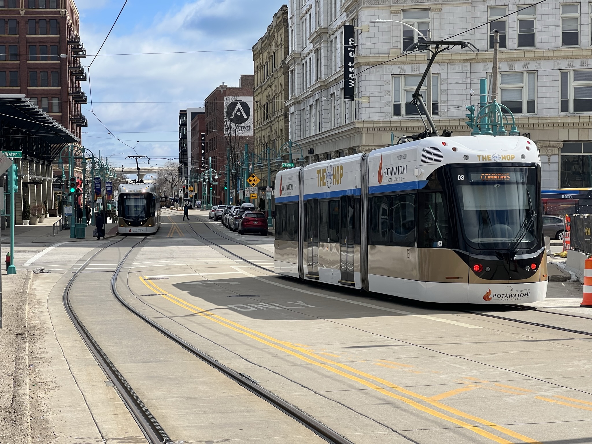
Two The Hop streetcars pass each on E. St. Paul Ave. Photo by Jeramey Jannene.
Milwaukee’s streetcar will return to its standard two-line configuration next week, ending a summer configuration that sent every streetcar to the lakefront.
The most notable impact is to eliminate a delay for northbound riders from the Historic Third Ward and Milwaukee Intermodal Station who are going to Wisconsin Avenue or points north by eliminating the use of the lakefront spur. But riders attempting to get to the stops along the lakefront spur will now need to pay attention to which streetcar they board.
The Hop will resume separate M-Line and L-Line service on Tuesday, Sept. 1, following the conclusion of Milwaukee’s summer festival season.
Since June 15, the streetcar has operated as the temporary Festival, or F, Line, combining its two routes so every streetcar stopped at the lakefront station inside The Couture. The seasonal configuration was intended to make the system easier for festivalgoers traveling to Henry Maier Festival Park to navigate.
The M-Line will operate between Milwaukee Intermodal Station and Burns Commons on its 2.1-mile route through downtown, the Historic Third Ward and East Town. It does not serve the lakefront.
The L-Line will connect the Historic Third Ward and central downtown area with the lakefront extension, which opened for passenger service in 2024.
Passengers can transfer between the two routes at five shared stations: Wisconsin Avenue northbound, City Hall northbound, City Hall southbound, Wisconsin Avenue southbound and Historic Third Ward eastbound.
Streetcars are marked with the route they are serving, and riders headed to or from the lakefront will need to use an L-Line vehicle or transfer between the two routes.
The seasonal F-Line configuration eliminated that distinction. A rider could board any streetcar and eventually reach the lakefront, but the arrangement also added approximately 10 minutes to northbound M-Line trips because every vehicle was routed through the 0.4-mile lakefront loop.
The change back comes as The Hop is recording higher ridership than it did a year ago.
Automated passenger counters recorded 301,634 trips through July, already surpassing the 301,170 rides recorded during all of 2021.
The system recorded 65,382 rides in July, up from 60,413 during the same month in 2025 and 63,373 in July 2024.
The Hop recorded 494,557 rides for all of 2025, down from 532,460 in 2024. Its busiest year remains 2019, its first full calendar year of operation, when the streetcar recorded 760,321 rides.
The return of the separate routes also restores the operating pattern envisioned when the lakefront extension opened.
Under normal service, two vehicles operate on the M-Line, while an additional vehicle operates on the L-Line. The L-Line uses portions of the existing tracks on N. Broadway and N. Milwaukee Street before traveling east to the lakefront, but does not extend to either Burns Commons or the Intermodal Station.
The L-Line has experienced operational challenges since opening, including issues involving track switches used to move streetcars between routes. Before the summer-long F-Line configuration began, The Hop had periodically substituted F-Line service for the L-Line because of digging near a portion of the track.
Riders can use the TransLoc app to see the real-time location of streetcars and determine which route an approaching vehicle is serving.
The Hop remains free to ride.
The 2026 city budget calls for The Hop to cost $6.5 million to operate. That expense is to be offset by $2.7 million in revenue, including $833,300 from a Potawatomi Casino Hotel sponsorship agreement and $1.8 million in federal grants. The remaining cost is to be offset by revenue from the city’s parking operations.
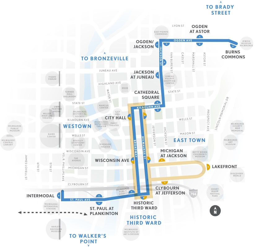
The Hop’s M Line (blue) and L Line (yellow). Image from The Hop.
Existing members must be signed in to see the interactive map. Sign in.
If you think stories like this are important, become a member of Urban Milwaukee and help support real, independent journalism. Plus you get some cool added benefits.


Transportation
-
Federal Grant Will Upgrade Bike-Pedestrian Crossings and Bridges
 Aug 30th, 2026 by Graham Kilmer
-
Classic Locomotive Steam Engine Getting Rebuilt in Central Wisconsin
 Aug 24th, 2026 by Avery Martinez
-
Federal Grant Will Help Modernize MCTS Buses
 Aug 21st, 2026 by Graham Kilmer














i think the Hop is terrific and if there was a donation box or slot, i would donate.
The hop is worth every dime it costs. I would love to see it extend to the baseball stadium with a stop at the Harley museum and the Domes.
There USED to be public bus transportation to the ballpark but I guess that was removed, and now we want the Hop to run there? Really? With tracks laid down where? Bring back the bus that we used right up Wisconsin Ave and into the parking area for crying out loud.
I think the bus to Am Fam Field was discontinued because the wonderful Connect 1 stops near the stadium but the walk is quite a hike compared to a convenient stop in the parking area. I have seen folks jump off the Connect 1 at Hawley and Bluemound and walk to Magoo’s or McGinn’s and wat for the next shuttle. Still, not as convenient as the former bus route into the stadium. But what can one expect from a previous MCTS administration whose policy actually encouraged fare evasion, IMO. The County Board can also be faulted for doing nothing to try to curtail the abuse.
Thank you, jmpehoski, for the heads up about using the Conect 1 bus and the Magoo/McGinn connection. I can see street parking free (ADA tag) at 35th/Wisconsin then going Connect 1 plus Magoo/McGinn shuttle inasmuch as my “hike to” days are over. Not terribly efficient, but the savings from avoiding the egregious parking lot charge (and still hiking a distance, to boot) — definitely worth it! WTAWTAW. (Where there’s a will etc). I usually take a bar shuttle anway though, from Shorewood with a beer to go,
Trmott: You’re welcome. Although I don’t know how much time the new route would save you, but at least it’s another option.