
What Makes Cities More Walkable?
All the city news you can use.
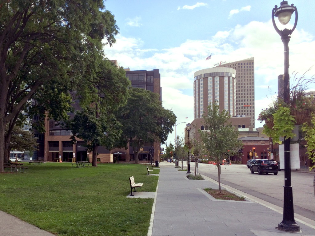
A view of Jefferson Street looking south. Photo courtesy of Cathedral Square Friends.
Every day at The Overhead Wire we sort through over 1,500 news items about cities and share the best ones with our email list. Each week, we take some of the most popular stories and share them with Urban Milwaukee readers. They are national (or international) links, sometimes entertaining and sometimes absurd, but hopefully useful.
Even the critics love (de)congestion pricing: Transportation Secretary Sean Duffy has been trying to end New York City’s congestion pricing program but every week that passes it gets more popular. Even lawyers advising the secretary believed he didn’t have a case in a memo that mistakenly was submitted to the court. But as travel times improve and delays are reduced for drivers and buses in addition to large reductions in noise, the only reason to keep trying to kill it is national politics. (Gabrielle Gurley | The American Prospect)
Dutch climate strategy changing: In order to promote the use of electric vehicles which have heavy battery packs, the Dutch government is proposing a new tax on vehicles based on size rather than weight. The Netherlands is behind on reaching climate goals and this would be one of a package of policies to reduce emissions over the long term. The current right-wing administration’s plans to increase speed limits and scrap measures to curb auto use was part of the problem according to the government’s own environmental assessment. (Dutch News)
What makes cities more walkable: An machine learning model trained on Hong Kong’s streets combined a survey of more than 100,000 people and Google Street View to help determine the variables that make places more walkable. It turns out simple things like more street trees, benches, windows, and streetlights were present in places where people liked to walk more. (Nate Berg | Fast Company)
Dallas’ makes building code changes: Dallas is the first city in the country with new rules for buildings under 7,500 square feet after a building code change was passed by city council. The change was made after a local developer saw that duplexes had less barriers to construction than missing middle buildings with between 3 and 8 units. The International Building Code, mainly a United States construct was to blame and Dallas decided to go with the more flexible International Residential Code used around the world instead. (Henry Grabar | Slate)
The ABC of mobility: New research modeled data from 800 cities in 61 countries to look at car use compared to income. Findings suggest that longer distances and more congestion are tied to less transit use and that driving is tied to higher incomes. Though different regions are likely to have different outcomes, with North America and Australia having more car trips and Eastern Europe and Asia using more transit while Western European cities are higher in active transportation. (Rafael Prieto-Curiel and Juan P. Ospina | Environment International Journal)
Quote of the Week
It is the unsustainable costs of our highway system that is bankrupting the Highway Trust Fund, and this leads to an ever-increasing share of general public funding to bail it out if nothing changes. Highways are a costly use of land, with one study finding that the costs of highway expansion outweigh the benefits by 3 to 1,even without factoring in external social harms like health impacts from added traffic pollution. It’s clear we should be rethinking the status quo of never-ending road expansion. Because the politics of dealing with the actual problem of funding our highway system is hard, there’s a desire to find a scapegoat. In this case, politicians have turned their attention to how much more efficient our vehicles are.
–Dave Cooke at the Union of Concerned Scientists discussing congress’ recent move to tax electric vehicles.
This week on the Talking Headways podcast, we’re joined by Kelly Porter, Assistant Director Transportation & Public Works for the City of Fort Worth. You can find a full unedited transcript here as well.
Want more links to read? Visit The Overhead Wire and signup.
If you think stories like this are important, become a member of Urban Milwaukee and help support real, independent journalism. Plus you get some cool added benefits.
Urban Reads
-
How Urban Housing Politics are Changing
 Mar 14th, 2026 by Jeff Wood
-
The True Cost of Urban Highways
 Mar 7th, 2026 by Jeff Wood
-
Should Amtrak be Broken Up?
 Feb 28th, 2026 by Jeff Wood


Comfortable shoes.
Compare the ROI of 1 mile of a 6-lane highway to the same of a mass transit system. 1 mile of freeway consumes approximately 14.5 acres. That is acreage taken out of use, generating not economic value.
A street level public transit system takes up between 4.5 and 5 acres, about i/3 the land use. The remaining 10 acres are available for development, housing, manufacturing, entertainment, etc. This increasing the economic activity. and tax revenues (without an increase in taxes.)
The conclusion: public transportation systems are far more cost effective than highways.
I believe I get the limited value of this study. It is a different way of looking at walkability.
In the end, so much of this is the same old. I mean, all the data and analysis in the study did not appear to generate much new understanding about walkability at all. Was it necessary, really? I come from the pre-big-data days when we did accomplished many things and built bustling cities, and didn’t need a data wonk to tell us to add trees and benches. Consultants gotta get paid…
The big elephant in the room is that the context for the study is Kowloon, one of the densest districts in one of the densest cities in the world. with bustling shopping and vibrant nightlife. His study is about cities but, given his interest in zeroing in on elements like “sidewalk,” “bench, and “crosswalk,” he might someday be interested in how these elements create more walkability *without* having a city as a backdrop. Isolate the factors. That might be interesting. What would happen if you put combinations of these elements along a half-mile stretch with nowhere to go to or stop at?
The study is clearly about “drawing correlations between the presence and combination of various elements in places with high rates of pedestrian activity.” Got it. But he seems to ignore the context that includes:
~ Ready alternatives as nearby as a block over and the other factors that help determine the walking choices we make. While I think he defines “walkability” as a combination of amenities that may or may not also be necessities (for some of us, a sidewalk is more than an amenity), there is a big difference between that “walkability” and whether someone will “actually walk” that stretch of cityscape. (Ex., I see the Milwaukee Riverwalk has sidewalks, benches, walls, windows, crosswalks, benches, and some lighting, but there aren’t a lot of people walking along it–or most anywhere downtown many days–unless there is a destination event around. I think he uses “wall” as a stand-in for “destination” or “opportunity” because he doesn’t like using “retail.”) Downtown Milwaukee has more walkers now because it has more people who live there and don’t just park their cars and take a skywalk to the office.
~ The fact most city walks are not simply meandering strolls, but trips with destinations, purposes, or at very least opportunities along the way. While Yang’s various elements may factor in more strongly if all other routes would offer the same or exceedingly similar destinations, purposes, and opportunities, he takes it for granted. One may well forego benches and even trees and windows if that “walkable street” were five blocks out of the way between me and the grocery store. I *would* go five blocks out of my way if I could also accommodate a trip to the gym or the dog park (with my dog).
Here’s my take, and it remains simple. create a place primarily where people will want to live, and those amenities will show up anyway, either as part of the attraction or because residents will ask for them. (So will Trader Joes or Target, given enough density to convince the companies. Also, make sure residents (and workers and visitors) have places to go and destinations that they will want to walk to. (Public transit in a city is not simply a mode of transportation, but a starting point and destination for walking.)
More benches would also be greatly appreciated. It seems like seating is being removed instead of added. A city would feel much more welcoming if there were places to rest.
Heh, heh, not to overstay my welcome, here, but there’s a great article about the Milwaukee RiverWalk in today’s Journal Sentinel by Jordyn Noennig:
https://www.jsonline.com/story/entertainment/2025/05/05/as-milwaukees-riverwalk-grows-could-it-be-more-than-just-a-walkway/82693054007/
Talks a lot about the original goal of *access*, and now turning more toward *activation*. The third “A,” *amenities* are only part of the solution, and the one that the City and the nonprofit Milwaukee RiverWalk District are best equipped to address.
A little too much hand-wringing from some people quoted about how *different Milwaukee is from San Antonio or Chicago.* Boo-hoo. With the right vision, strategy, partnership, and investment, the 3-4 block RiverWalk stretch between Kilbourn and Michigan Aves. could become a rockstar stretch of river famous nationwide and, dare I say, the world over… In 15-20 years, the stretch from Kilbourn to to the Confluence could become the beating heart of the City.