The Battle for Lake Michigan’s Shoreline
As water levels surge, Wisconsinites erecting walls. But that could hurt downstream beaches.
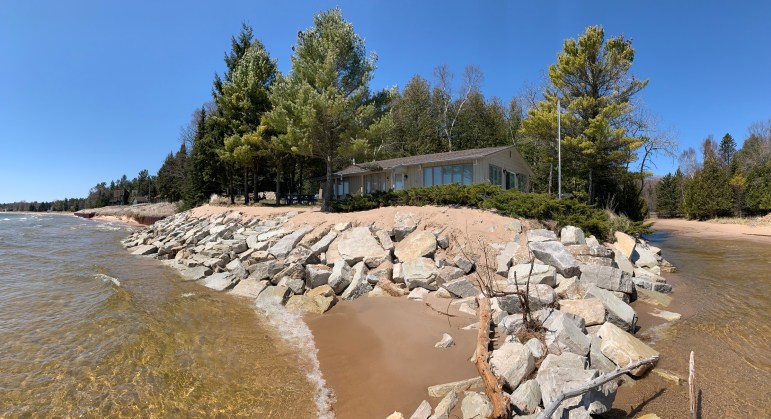
As they watched waters rise, Bo and Mindy Ellis paid for a new stone revetment to prevent their home on the south side of Whitefish Bay Creek in Door County, Wis., from getting washed into Lake Michigan. The couple waited months for a professional to do the work as other northeast Wisconsinites flooded contractors with calls amid erosion worries. Photo taken May 12, 2020. Myles Dannhausen Jr. / Door County Pulse
Bo and Mindy Ellis knew that they needed to act to keep their house from sliding into Lake Michigan.
With their home perched 8 feet above the waves and 20 feet from the shore of Whitefish Bay in Door County, Wisconsin, the couple first watched with fascination last year as the lake’s waters rose, changing their beach each day.
But curiosity turned into anxiety as nature whittled away the shoreline.
“At first, I was going to wait and see how the water level played out,” Bo Ellis said. “But the high water was present for such a long time that I realized I needed to do something.”
The Ellises had to wait for a fix. As other northeast Wisconsinites watched their beachfronts shrink in 2020, they overwhelmed contractors with bookings, requiring the Ellises to wait seven months for a professional to fortify their stone barrier to block the waves. At around $250 per linear foot, the sticker price for protecting 150 feet of shoreline eclipsed $37,000. The waters have since eased, but the Ellises know they will rise again.
High waters have sped erosion along Lake Michigan’s shoreline, swallowing beaches, damaging public lands and draining homeowners’ savings. Wisconsin cities from Milwaukee to Green Bay and small communities in Door County are confronting erosion — a key portion of climate impacts that Wisconsin’s shoreline communities expect to cost at least $245 million over the next five years.
Scientists expect erosion to worsen as climate change brings more volatility to Great Lakes water levels, particularly as warm temperatures interplay with more frequent, intense storms. While that may yield extremely low waters in some years, experts also expect dramatic shifts to high waters — with heavy rains and wind adding power to waves that punish shorelines. Between record-low waters in January 2013 and a record-high in July 2020, Lakes Michigan and Huron collectively swung more than 6 feet.
That has sent lakefront homeowners scrambling to protect property by adding seawalls or riprap — slopes of rock or concrete that absorb force from waves. The Wisconsin Department of Natural Resources is seeing a surge in applications to construct such barriers in Door County.
But artificial barriers can accelerate erosion downstream, blocking sand from naturally replenishing beaches elsewhere. Ellis said he hasn’t heard such complaints from his neighbors. But nearly all of them now have revetments — many constructed in 2020.
In Ozaukee County, a $12 million structure finished in 2007 stabilized an eroding bluff that separated Concordia University Wisconsin from Lake Michigan, but it also altered the beaches of downstream neighbors — leading to litigation and expensive repairs of the collateral damage. Experts call that episode just one example of how shoreline armoring can trigger a domino effect along the coast.
Eying such consequences, water experts and environmental advocates are calling on Great Lakes communities to find new ways to confront erosion and protect shorelines for future generations.
‘Fight against nature’
Lake Michigan’s levels have tended to fluctuate in cycles throughout its recorded history, swinging up or down roughly every three to 10 years. Shoreline residents call those ebbs and flows a part of life. But ferry boat captains, contractors and park superintendents told Wisconsin Watch that they’ve never seen the water swing as wildly as it has over the past decade.
Unlike oceans, which are steadily rising with global temperatures, water levels on the Great Lakes largely depend on the weather — rising with deposits from rain and snow, waning as water evaporates.
More intense storms are adding water to the Great Lakes. But the region’s temperatures are also rising faster than elsewhere in the United States — accelerating evaporation. These opposing forces are creating an increasingly powerful “tug of war” effect, scientists said, causing more dramatic fluctuations of lake levels and accelerating erosion, particularly during high-water years.
Relatively speaking, the Great Lakes are new features, carved by the last glacial retreat a few thousand years ago — an instant in geological time, said Guy Meadows, a professor at Michigan Technological University and director of its Marine Engineering Laboratory.
The retreating ice left a deep basin with steep sides, particularly in the case of Lake Michigan. Absent human intervention and new climate trends, Lake Michigan’s shoreline has traditionally eroded by an average of about a foot each year as the basin naturally broadens, said Meadows.
But increasingly frequent storms are strengthening winds across the lake, energizing waves that pummel shorelines with greater force. In 2020, waves carried up to 25% more energy compared to the low-water year of 2013, Meadows said.
“The natural process is for people to try to fight against nature,” by building stone or concrete barriers, Meadows said. “When we go through episodes of extremely high water levels, like we just went through in 2020 for Lake Michigan, that erosion rate goes up catastrophically, from one foot per year to 10, 20 or 30 feet per year, depending on where you are on the shoreline.”
Flood of permits shows urgency
One reflection of Lake Michigan’s volatility: The deluge of DNR permit applications from property owners installing shoreline protection.
As Lake Michigan’s waters climbed between 2018 and 2020, those applications jumped from 61 annually to 149 — a 144% increase.
Meanwhile, requests for “emergency self-certifications” — a temporary DNR permit to protect homes or other structures facing imminent danger from accelerating erosion — soared more than 830%, from fewer than 30 applications in 2018 to 280 in 2020.
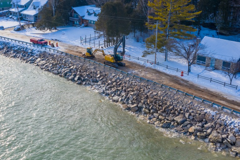
Town of Baileys Harbor, Wis., maintenance crews and contractors work to restore residential access with giant limestone boulders after the road collapsed into Lake Michigan due to high water levels. Photo taken Dec. 19, 2019. Brett Kosmider / Door County Pulse.
Those figures offer only a partial glimpse of Lake Michigan shoreline. The DNR issued most permits in Door County, which it considers an “area of special natural resources interest” — a sensitive habitat where permits are required.
Property owners to the south are not required to seek permits for new barriers, so long as they meet DNR’s standards.
Kyle McLaughlin, waterway team coordinator with the DNR, said the agency introduced emergency permits in recent years to make bureaucracy easier for DNR officials and property owners facing urgent threats from erosion.
Increasing threats from erosion and demands for intervention in Door County “rapidly increased and strained the department’s ability to be as responsive on the front end,” McLaughlin said.
The DNR grants emergency permits on the condition that applicants apply for a more formal review within a year. If a project fails to meet state standards, the agency works with the landowner and contractor to fix it, said Crystal von Holdt, a DNR water management specialist.
Residents weigh in
The growing demand for barriers prompted the DNR to begin a strategic analysis of the Door Peninsula to better understand the impact of shoreline erosion, how the department responds to it and what the intervention means for the environment.
The agency expects to complete the analysis in 2022. Shoreline stability is top of mind for the majority of those who responded to a DNR survey during that process.
How could federal agencies limit damage from shifting water levels? Opinions vary. Crack down on the greenhouse gas emissions speeding earth’s warming, build homes farther from the lakeshore or let landowners protect property however they can, some survey respondents answered.
“Increase and enforce setbacks, limit shoreline development, increase vegetation and native plantings,” one commenter said.
Wrote another: “Leave it alone. Stop trying to save rich people’s property. Water levels change. I have watched it my whole life. Let nature do its thing.”
But letting nature take its course can be tough for property owners to stomach as waves encroach.
Coastal domino effect
And protecting one property can damage another, sparking conflict.
The dispute that played out at Concordia University Wisconsin, a private college just north of Milwaukee, illustrates how armoring a shoreline can set off a domino effect.
In 2007, the university finished fortifying a 130-foot bluff and building a 2,700-foot-long rock wall to buffer waves. The $12 million project was among the largest built along Lake Michigan in Wisconsin.
Neighboring landowners soon noticed changes to their property.
While barriers like seawalls can protect the property immediately behind them, they can cut off downstream beaches from replenishing sands, accelerating erosion by further exposing sand and bluffs to wind and water, Meadows said.
Meadows, an expert in shoreline dynamics, identified Ozaukee County as a hotspot for bluff erosion.
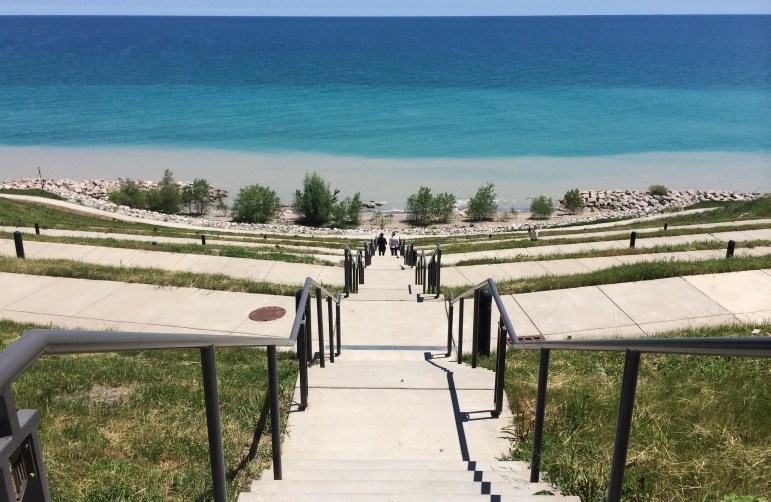
In 2007, Concordia University of Wisconsin, in Mequon, finished fortifying a 130-foot bluff and building a 2,700-foot-long rock wall to buffer waves. The university credits the project with preventing parts of campus from sliding into Lake Michigan. But the project also altered downstream beaches, spurring litigation and expensive repairs. This photo shows a portion of the project in June 2016. Aaron Volkening via Flickr Creative Commons license
In 2011, two neighboring couples sued Concordia, claiming that the massive seawall worsened erosion on their properties and washed away public beaches. Owners of at least 13 neighboring properties built or reconstructed barriers in the years following Concordia’s construction, the Milwaukee Journal Sentinel reported in 2015, resulting in a $1 million-plus price tag for neighbors.
Chin Wu, a professor in University of Wisconsin-Madison’s Department of Civil and Environmental Engineering, has studied the Concordia project for years. He authored a 2014 Journal of Great Lakes Research article finding that the Concordia project may have worsened bluff erosion south of the project, the same direction the current travels along the shore.
A jury agreed in 2014 that Concordia’s seawall caused “significant harm” to neighbors. But the jury found that Concordia was not negligent in its construction, and it awarded no damages. Still, the university said it paid for at least five repair or reconstruction projects downstream.
Concordia did not offer comment for this story. In court, it did not deny that its wall affected neighbors, according to media coverage of the lawsuit. The university successfully argued that it had the right to project its land — like any property owner — from sliding into Lake Michigan.
On its website, SmithGroup, the project’s designer, says the work “successfully stabilized and beautifully restored” the bluff and “dramatically transformed the University’s relationship with the lake and surrounding community” — allowing for the restoration and addition of trails, an amphitheater, a beach and habitat areas for education and research.
But the project has accelerated erosion on downstream properties from around 9 inches to more than 7 feet per year, Meadows said. “So there are just enormous losses on the downdraft side of that structure.”
When waves hit seawalls, water reflects back toward the lake, pulling sand farther from the shoreline. The force gradually pulls the sand deeper into the lake until it can no longer replenish the beach.
The walls don’t last forever.
When enough sand in front of a seawall washes away, the wall will fall forward or otherwise fail, Meadows added. Aerial maps of Lake Michigan show bands of sunken structures once built to protect the shoreline. Now beneath the water, they lurk as hazards to people and wildlife.
The lake will inevitably claim whatever structure was built to alter its waves, Meadows said.
“You can look to see where structures were added to combat the high water level in 1986 and where they are located now. And most of those are out in the water, because they failed.”
‘Paradox of beach dynamics’
Richard Norton has noticed that shoreline residents get stuck on one concept as he urges them to consider lake levels in their planning: The lakefront properties they own today will look much different in 30 years.
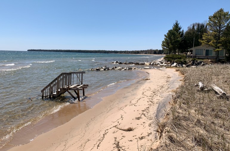
The position of steps going into Whitefish Bay in Door County illustrates erosion along the beach. Photo taken May 12, 2020. Myles Dannhausen Jr. / Door County Pulse.
“In order for the beach to stay the same, it has to be able to change. It has to be able to move and shift and grow and decrease over time as lake levels go up and down as conditions change,” said Norton, a professor at the University of Michigan’s Taubman College of Architecture and Urban Planning and a community planner and lawyer by training. “That’s the paradox of beach dynamics.”
Armoring the shoreline attempts to “pin” to a precise location, disrupting sand’s natural movement and possibly losing beach, he said. But without protection, homes built too close to the lake face threats from water.
“You can save the beach or you can save the beachhouse. You can’t save both,” Norton said.
The dilemma prompts thorny conversations about balancing property rights with responsibilities to protect the public shoreline for future generations.
“Part of the message that I give to local officials is you have more authority to act through your zoning than what you may think you do,” Norton said. “You have the ability to regulate land use throughout your jurisdiction.”
For cities and townships, that could mean adopting and enforcing setbacks — or revisiting plans every five to 20 years as shorelines move over time. For homeowners, this could require physically moving houses farther from the shoreline — an expensive process, Norton acknowledged, but often no more costly than building and repairing large seawalls. Some landowners have moved their homes multiple times, he said.
“Those concepts are really hard for local officials to understand because it’s a painful thing to acknowledge,” Norton said. “Property owners want to have certainty. They want to know they can build a house and they want to know that it can be there forever, and that the zoning isn’t going to change underneath them.”
Norton has worked closely with about a dozen shoreline communities on Lakes Huron and Michigan — yielding mixed results.
One community barred new seawalls altogether. Another adopted a setback. By measuring past erosion and applying that to a forecast, the community created standards for how close developers can build from the shoreline. Leaders of an adjacent township, however, did not follow suit — with town board members reluctant to regulate property rights, Norton said.
Norton is sympathetic to people who invested time and money into their shorelines only to see homes edging closer to a bluff or toppling into the lake. But he said the problem extends far beyond their property lines.
“They’re fighting a natural process and forces that are ultimately going to prevail,” he said. “And it’s going to have consequences for a very long time, in terms of the character of the shoreline, and how viable and ecologically functioning it is.”
Building resiliency
Experts told Wisconsin Watch that Lake Michigan’s shoreline needs managing, but the specifics depend on location.
Large stretches of shoreline, particularly around urban centers, keep cities from flooding and protect highways, boardwalks, commercial centers and more, said Drew Gronewold, a University of Michigan associate professor of ecosystem science and management and expert on weather’s impact on the Great Lakes.
“Those are environments where turning it back to a natural state or giving it back to the public trust is really not an option. That ship has sailed,” Gronewald said.
Less-developed communities should adopt setbacks while preserving public park land, he said.
“I think we need to make sure that those areas stay in the public trust and everything is done within our power to make sure that those public lands stay public and that they’re not ultimately developed,” Gronewald added.
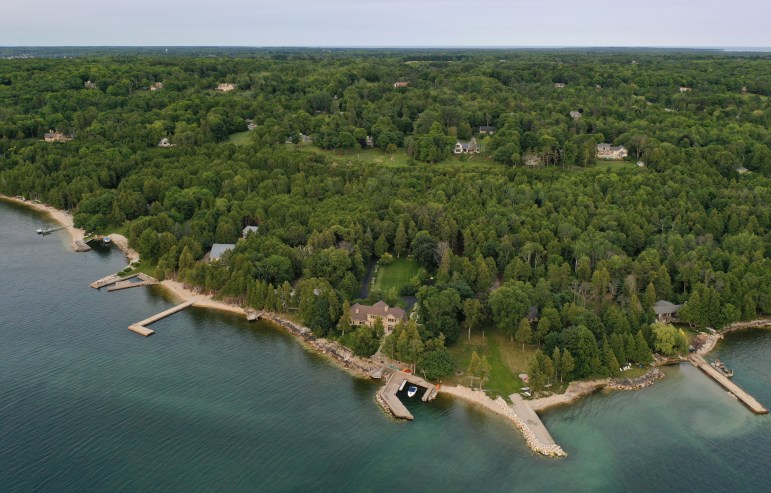
Lakeshore homes are seen in the Door County, Wis., village of Ephraim, on July 31, 2021. Many homeowners have placed large rocks along the shoreline to confront erosion amid wild swings in Lake Michigan’s water levels in recent years. Coburn Dukehart and Tad Dukehart / Wisconsin Watch
Wu, who studied how Concordia’s seawall affected the surrounding environment, endorses an alternative approach to shoreline management: nature-based coastal solutions — harnessing resources like sand, vegetation or coral reefs to create natural barriers that also benefit fish and wildlife while allowing for some shoreline movement.
While natural barriers may not offer the same protection as steel or concrete barriers, they’re often cheaper to build. And they help shorelines rejuvenate faster after stress from storms or high water, Wu said.
The Dutch took a similar approach when it formed the Zandmotor — or Sand Motor in English — the world’s largest experiment in coastal storm and flood defense. So far, it’s a remarkable success.
As climate change and rising seas threatened the Netherlands’ coastline, the Dutch strategically dumped onto the beach about 28 million cubic yards of sand, which could fill the Mercedes-Benz Superdome in New Orleans six times, the Times-Picayune and Advocate newspapers reported. Nature did the rest.
Over time, the wind has spread the sand, adding about 3,500 acres of new beach to protect The Hague and a wider inland area. New sand and dunes coated roughly 5 miles of coastline after nearly a decade. Fish, shellfish and birds have thrived in the new environs, the New Orleans newspapers reported.
The Wisconsin DNR said it encourages nature-based solutions, including use of vegetation and brush to buffer shorelines under certain conditions. Dumping sand on public lake beds requires a waterway permit and a DNR review of environmental impacts.
“As citizens of the great state of Wisconsin, we want to see a fundamental change to the way we do things. Otherwise we’ll keep going farther and farther downstream until we see all our shoreline hardened and lose our beaches,” he said. “I don’t think that’s what any of us want.”
Jack Kelly contributed reporting. This story was produced as part of the NEW (Northeast Wisconsin) News Lab and in partnership with the Door County Pulse. The nonprofit Wisconsin Watch (wisconsinwatch.org) collaborates with Wisconsin Public Radio, PBS Wisconsin, other news media and the University of Wisconsin-Madison School of Journalism and Mass Communication. All works created, published, posted or disseminated by Wisconsin Watch do not necessarily reflect the views or opinions of UW-Madison or any of its affiliates.
-
Legislators Agree on Postpartum Medicaid Expansion
 Jan 22nd, 2025 by Hallie Claflin
-
Inferior Care Feared As Counties Privatize Nursing Homes
 Dec 15th, 2024 by Addie Costello
-
Wisconsin Lacks Clear System for Tracking Police Caught Lying
 May 9th, 2024 by Jacob Resneck


