City Could Require Laser Scanning of Buildings Slated for Demolition
Effort would create a database of lost buildings.
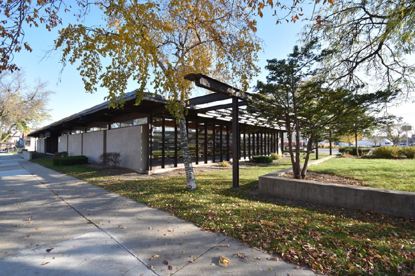
Forest Home Library. Image from the City of Milwaukee.
A proposal pending before the Common Council would add a new way for the city to record its history.
Property owners seeking to demolish buildings would be required to conduct a laser survey of the exterior of their structures.
“It’s far more accurate than photographs or measuring buildings by hand,” said UW-Milwaukee architecture professor Matt Jarosz to members of the Public Works Committee on May 12th.Jarosz has served on the city’s Historic Preservation Commission since 1993. “In that time we have seen a lot of buildings removed, with no documentation or evidence required,” said the professor.
He compared the end product of laser scanning to the experience of wearing a virtual reality headset. A three-dimensional rendering is generated.
“It’s far more accurate than photographs or measuring buildings by hand,” said Jarosz.
Jarosz estimated that the city’s largest buildings, including Milwaukee City Hall, could be surveyed for at most $500. He has worked with students on scanning buildings, noting that the resulting documentation yields quality teaching materials and historical records. It would also help recreate buildings or features in the future.
“It’s a fairly conventional thing in the engineering industry,” he said. Jarosz said a number of companies in the area provide the service.
He singled out the Forest Home Library as a building worthy of such a scan. “It’s a great mid-century modern building, and to have evidence of that through laser scanning is far more accurate and valuable to historians than photographs,” said Jarosz, who was on the losing side of an effort to historically protect the building.
Alderman Robert Bauman, a preservation advocate, is sponsoring the resolution.
“We’re aware of it, but we’re not totally familiar with this technology,” said Department of Neighborhood Services operations manager Thomas G. Mishefske.
Mishefske asked how trees and other obstructions factor in, and if their removal would add to the cost.
Jarosz said scanning from multiple points avoids the need to cut shrubs or chop down trees. But things like scaffolding would be unavoidably captured.
Plenty of questions were raised for which no answer was immediately available, including which buildings would be required, how the data would be stored and who would monitor the program.
“There are a lot of details that need to be flushed out,” said Bauman. He called on DNS to work with the UW-Milwaukee School of Architecture and Urban Planning.
“We are really asking someone to develop a program and then we can develop the program,” said Bauman. The resolution was held for a future meeting.
Jarosz and Mishefske promised to report back.
Eyes on Milwaukee
-
Church, Cupid Partner On Affordable Housing
 Dec 4th, 2023 by Jeramey Jannene
-
Downtown Building Sells For Nearly Twice Its Assessed Value
 Nov 12th, 2023 by Jeramey Jannene
-
Immigration Office Moving To 310W Building
 Oct 25th, 2023 by Jeramey Jannene