Tear Down Another Freeway in Milwaukee?
The debate over the reconstruction of the Hoan Bridge is one that has ignited controversy in Milwaukee for almost a full year now. Southsiders under the direction of Supervisor Patricia Jursik have united around the Save the Hoan Coalition. Meanwhile, Milwaukee Alderman Robert Bauman has presented a differing vision for the future of the Hoan with eight principles that should be followed in any reconstruction effort. There is an awful lot of confusion around the issue, and the manner in which WisDOT has handled it is far from their usual course. This article examines the potential source of the debate, and a potential outcome that is a win-win scenario for both the City of Milwaukee taxbase, and southside and suburban commuters.
The Setup
Before considering the merits of either proposal, it’s important to understand why and how the debate started in the first place. On August 22nd, 2008, The Business Journal of Milwaukee floated a trial balloon for the Wisconsin Department of Transportation (WisDOT) quoting Transportation Secretary Frank Busalacchi discussing the feasibility of tearing down the bridge. The Milwaukee Journal Sentinel was quick to follow with more attention to the issue, including react quotes from south side politicians.
Why did WisDOT broach the issue in such a way? Proposing eliminating a part of the interstate system isn’t exactly business as usual for WisDOT. The department has lead a $810 million reconstruction of the Marquette Interchange, is in process spending $1.9 billion expanding and rebuilding I-94 to the state line, and is lining up plans to expand the Zoo Interchange at a potential cost of $2.3 billion. Par for the course for WisDOT would be expanding the capacity of the bridge, adding off-ramps, and spending more than the project before. Eliminating a section of a federally-designated Interstate highway just isn’t a plan that would likely emerge from WisDOT, let alone one that they would float as a trial balloon.
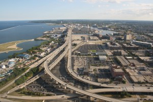
The Hoan Bridge as seen from the US Bank Center top floor. The bridge itself is rather narrow, but it’s the ramps at the end that consume all the space.
So where did the discussion truly originate? The United States Department of Transportation. The only logical scenario is that the federal transportation department has informed WisDOT that they wish to remove the federal designation from the bridge. One would presume that the facts that the bridge needs to be redecked and that interstate-level federal support won’t be available to financially support the redecking would spur one into proposing different ideas that would reduce the total lifetime cost of the highway. If the federal government really is looking to remove the designation, WisDOT’s search for options seems rational.
Why would the U.S. DOT’s Federal Highway Administration look to remove that interstate designation? Perhaps because traffic counts are too low at 40,000 vehicles per day. Maybe because they’re looking to remove spurs as a way to save money. It’s possible that the FHWA is merely looking to reduce the total mileage of the system as a way to save money, especially with sections that are due to be reconstructed soon. It’s also possible that Wisconsin, by funding the Lake Park Highway has shown a willingness to fund the stub, and the FHWA is just looking to save money by giving Wisconsin the rest of the stretch from the Marquette Interchange. I don’t have an exact answer, but all signs point to a behind-the-scenes force prompting WisDOT’s action on the Hoan Bridge.
How is WisDOT handling this? It would appear they’re content to let groups in Milwaukee fight it out, perhaps in hopes of raising some funds for any necessary work from the city of Milwaukee in TIF dollars or another form. They’ve committed to studying the process, commissioning HNTB to conduct the study.
What Could Be Gained?
Reconfiguring the North End of the Hoan Bridge
The north end of Interstate 794 as it turns to head west towards the Marquette Interchange occupies some of the most expensive real estate in the city. Development on the north end of the bridge hasn’t been inhibited as much by the bridge itself as it by the overbuilt ramps that are part of the partially completed Lake Interchange that was designed when the Lake Freeway was planned to continue up the lakefront and connect with the Park East Freeway.
The Lake Interchange simply isn’t needed anymore (nor was it ever), and a solution that encompasses the needs of southside commuters and Milwaukee. The Third Ward and East Town contain undoubtedly the most expensive office space in the city. It’s no wonder that residents to the south want to protect the Hoan, it ensures access to the highest paying jobs in the city outside of Miller Park and the Bradley Center. It’s time to look at reconfiguring the bridge as a way to connect residents to those jobs (and to the countless nearby cultural amenities), and as a way to grow the availability of jobs and amenities at the north end of the Hoan.
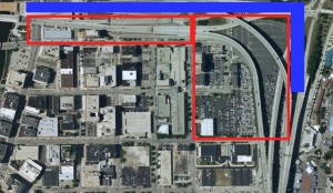
The red-framed land is the land that would made available for redevelopment as a result of the bridge reconfiguration. The blue illustrates the street-level boulevard that would replace the elevated freeway.
How can that be done? Simply land the bridge earlier. Currently the bridge comes down to ground level at Michigan Street. If possible from an engineering perspective, leaving the iconic, existing bridge in place and dropping the ramp at a faster rate would yield these savings without the sacrifice of any buildings or stages at the Maier Festival Park. It would likewise not noticeably lengthen the southside to downtown commute. Drivers that use the Hoan would still have quick access to downtown over largely the same bridge, but would enter a reconfigured street grid that would diffuse them to their downtown destination.
Lowering Interstate 794 from the Milwaukee River to the east with a smooth-flowing street-level boulevard would finally unite East Town with the Third Ward. This would open the land inbetween to development with stunning lake views, and logically unite the Milwaukee Art Museum and Discovery World with the boutique-laden Third Ward. Furthermore, building an lower and more attractive bridge would further encourage development near the western reclaimed lane, which unlike the other reclaimed land would be deprived of a lakeview. Depending on how far south the Hoan Bridge can be landed, up to 500,00 square feet of land could be opened for development. Chicago Street probably represents the most opportunistic position, with St. Paul Avenue being the easiest position outside of a reconfigured Michigan St.
What About the Park East Issues?
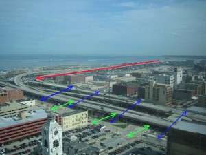
The Hoan Bridge as it comes into downtown, as seen from the Chase Tower. The green lines indicate the massing of a new street-level boulevard, while the blue lines reflect the current space consumed by the elevated freeway. The red line shows a reconfigured trajectory towards the ground.
This land is far more valuable than the reclaimed land from the Park East Freeway based on location alone. It’s closer to the lake, and inbetween two economically healthy neighborhoods. To compare the potential of a development like this to the Park East is borderline apples to oranges. Projects like the canceled Palomar hotel and condo development would certainly happen in the land made available between the Third Ward and East Town, likely without any public financial assistance. One of the same challenges that faces the Park East unfortunately rears its head with Milwaukee County being the land holder, but with a better plan from the start the City of Milwaukee Department of City Development can be put in charge of managing the land sales.
What’s The Result?
At the end of the day, as the above illustration shows, access is still ensured to downtown via 794 and the Hoan Bridge. Provided the configuration can be made to work, the iconic bridge that people have come to know and love is preserved, and it’s still very easy to get from the southern suburbs and Bay View into downtown. Nothing that prevents access from the southside to downtown. Worst-case scenario is a slightly lower Hoan that maintains the same look and feel as the previous bridge, yet comes to the ground quicker than the current bridge. The only traveler affected is the one looking to use Interstate 794 from the southern suburbs to head west to Waukesha and beyond, they would have to instead start their journey heading west to get on I-94, an extremely minor inconvenience. The plan blends the desires of the Save the Hoan coalition and Alderman Robert Bauman. The benefit? More than 500,000 square feet of new land for development, and a more attractive and interconnected lakefront. Nothing to sneeze at when it comes to developing a healthier Milwaukee.











Excellent article. The same case as the north interchange could be made for the south interchange as it is similar in age and the amount of land that it consumes. The popularity/feasibility of removing the south interchange would rely on the placement of the southside KRM stop (E Lincoln vs. E National Aves.) but the economic development potential near the Laker vessel, commercial activity at the Port of Milwaukee, the proposed Army Reserve site “Solar Village”, and the healthy nearby commercial districts bodes well for redevelopment similar to the north interchange. One issue at play is that an essential re-decking of the Hoan is approaching (10 years) and expensive (roughly $400 mil) while the redone interchanges look to be an additional $100-150 mil each and “cosmetic” from an engineer’s point of view. The engineers drafting the plan will have to be sold on the economic benefits and downstream impact with a convincing argument as their priorities lie in the cost of re-decking and maintenance.
I think that as far as reducing the land used by the bridge and it’s ramps; if it was built as a highway but was designed for it’s current and future traffic loads that the ramp length and curve radius’s would be reduced greatly while the lanes would become 2 in each direction so that even if it kept the same height, and same connections (which it seems is what the south-siders seem most concerned about) with the streetgrid and the freeway that we could open up half the land under the roadways for better development.
[…The only traveler affected is the one looking to use Interstate 794 from the southern suburbs to head west to Waukesha and beyond, they would have to instead start their journey heading west to get on I-94, an extremely minor inconvenience…]
I think you underestimate how many travelers use 794 for precisely this reason. While there are a good deal of people working in downtown, it is the ease of commute from the south side out to the ‘burbs that I think has helped the south side flourish. ANd alternatives? 43/94 is already a zoo and the bypass is a laughable attempt to get west during the morning rush hour. 794 is as much a lifeline to outlying areas like Brookfield and Waukesha as it is to downtown.
I think the whole freeway spur should come down and be replaced w/ a street level boulevard. Keep in mind that Thirdward and Eastown/Downtown are also peoples homes and neighborhoods. Freeways don’t belong in neighborhoods or along a beautiful Lakefront. Replacing w/ a street level bridge & grid would likely only reduce the speed limit from 50-40mph and if there were rush hour restrictions on a lift bridge scenario southsiders commutes would be extended only slightly. Anyone wanting to bypass the street level bridge could always use 94/43 to get into downtown. The needs of the whole city should be considered, however, the needs of the 15K people living in the neighborhood surrounding the interchange should trump the 40K cars that bypass those neighborhoods each day.
I think the 794 spur should have come down as well making downtown a complete neighborhood and not really affecting any suburbanites commute more than 10 minutes. Dwtn bound traffic could be dropped btwn 11th-6th streets having a boulevard just like McKinley Ave take that traffic the rest of the way to the Lake Front/Downtown Business District.
This would make the downtown area more beautiful, livable, raise property values, attract more residents/business, etc…
Consider the costs of installing a bascule bridge on a limited access highway for the commercial Port of Milwaukee. Similar to S Water Street, the at-grade Hoan would have to install some form of movable bridge to allow water traffic through. The immense size and low speeds of laker vessels moving into the port would require bridges up (and traffic stopped) for an average of 15 minutes a clip. Multiply this by 12 and that’s how much time would be lost for Hoan bridge commuters in and out of downtown. Never mind an at-grade commute through the MMSD cesspools.
Any movable bridge would have restrictions on when it could/couldn’t open to minimize disruption to users of the roadway. Currently the Hoan shuffles straight through the heart of MMSD and oil tanks in the area. At least running the road to the west of the port would give everyone a little distance.
As for the cost of a new bridge, the Knapp Street Bridge cost 11,000,000 in 2003 and anyone knows it’s cheaper to build a road on actual ground versus spanning the entire distance.
A redecked Hoan won’t contribute anything more, but a new lower bridge will open up views of the lake while creating access to huge areas of now hard to reach waterfront.
Why can’t we work this into a win-win? Why can’t we push for the state to rebuild a lower bridge and build an extension down to Ryan road at the same time? A few loud and angry people want to make this into an us vs them issue, but everyone in our corner of the state can benefit if we all come together.
An excellent look at the topic, except that FHWA says it has NOT informed WisDOT that they wish to remove the federal designation form the bridge. That assumption in Mr. Jannene’s piece appears to be wrong.
And the 40,000 traffic count is actually higher than many sections of the federal highway system in Southeast Wisconsin.
Any change in the highway designation would be initiated by a DOT decision to replace the bridge with a less-robust structure and roadway. It would not be initiated by FHWA.
Why not extend 794 into Racine county, the city is 15 minutes from the freeway currently. the state has totally overlooked the lack of quick access from northern racine county into milwaukee. Hwy 32 and 38 are relics from the 1950’s. We deserve better than this and a slow train with many stops (KRM) leading to Milw is not the answer.