
New Bike Trails Coming
Beerline Trail from Keefe to Capitol Dr. will be completed in July and Phase 4 of Oak Leaf Trail north from Estabrook Park in November.
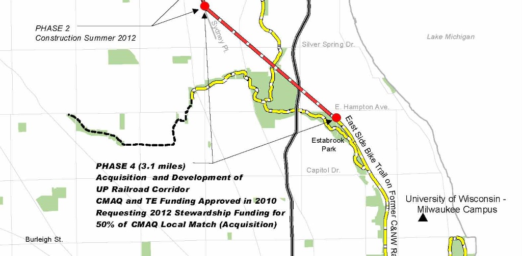
Map of the Oak Leaf Trail extension. Click the image for an expanded map.
Yesterday we learned that Milwaukee County Parks will fill the missing link that connects the Oak Leaf Trail to the Ozaukee Interurban Trail this year. That’s right, they expect that by November, the contractor should finish construction on the long awaited and final Phase 4 of the Oak Leaf Trail extension from Estabrook Park to the existing trail built a couple years ago that ends at Sydney Place.
Let’s keep an eye on progress and weather as we near November. Then how about we organize a Ride to the Border with our pals up in Ozaukee County. Milwaukee County people could start down near Brady Street, ride the trail north and meet somewhere near County Line Road?
The second great news came from City of Milwaukee Bicycle and Pedestrian Program Manager Kristin Bennett who told the County Trails Council that by the end of July, the city expects to finish construction on the extension of the Beerline Trail from Keefe to just north of Capitol Drive. That segment also includes The ARTery, so not only will the trail be done, but there is a well funded group revved up to continue their great community arts programing.
But wait, the good news keeps coming. Thanks to the efforts of the volunteers for the Oak Leaf Trail Discovery Tour, The Park People and some generous private sponsors, there is finally a new map of the Oak Leaf Trail. The map is more than just an Oak Leaf Trail map though, as it includes a complete guide about all the area MTB trails, hiking trails, water trails, municipal trails and even eBird hotspots. This first edition of the newly designed Milwaukee County Trails Map and Park Guide has a detailed description of the different amenities and facilities in all County Parks! You can purchase a map for $5 at many local bike shops or from the Bike Fed.
If that and a ride isn’t enough to cheer you up on a dreary Bike to Work Day, the proceeds from the sale of the new Milwaukee County Trails Map and Park Guide go to purchase permanent trail counters. The county and the city already have some trail counters installed and they have been busy collecting data 24-7. The counter on the Oak Leaf near where it ends at Estabrook Park has witnessed 210, 875 people enjoying the trail since it was installed last July 28th. The biggest day was Saturday, Aug. 23rd with 3,113 trail users and the slowest day was in February when 151 braved the cold and snow.
The City installed a trail counter on the Kinnickinnic River Trail between Maple and Washington May 1st, and that has already logged more than 5,600 people on that short segment of trail that gets you off S. 1st Street and connects to S. Water Street, which was repaved with many improvements for cycling that we reported about in this post last year.
This article was originally published by the Bicycle Federation of Wisconsin.
Bike Czar
-
Join a Bike Ride Under the Polish Moon
 Jun 1st, 2018 by Dave Schlabowske
-
9 Reasons to Join National Bike Challenge
 May 4th, 2018 by Dave Schlabowske
-
Biking Through the Mindoro Cut
 Apr 27th, 2018 by Dave Schlabowske


Darn, I was really hoping there’d be additional trails for Bay View. The Oak Leaf is the thing I miss the most living in Shorewood…made the commute to downtown so pleasant.
I hope there are plans to resurface trail from Sheridan Park through Warnimont and Grant Park soon.
The Sheridan to Grant section will be rebuilt this summer.
The Parks Department will need to keep tabs on the Cudahy Gun Club, (they already are.) The gunners need to relocate their range and are requesting a different location – one that would relocate the bike trail closer to the road. I suggest you all tell the Parks Department to have them move out of the park!
I can confirm that the railway (which technically still owns the land) has been reclaiming ties and rails along the right-of-way, particularly at the south end in Estabrook and at the bridge over Green Bay Ave over the past two weeks. This will clear the way for the sale to be finalized and work is expected to begin early summer, according to Glendale mayor Bryan Kennedy on Facebook.
Dear Bike Czar – Lots of great news. My question: is there ever talk of putting bike lanes on Brown Deer Road west of i-43? Any time I drive on that road, with its three uncrowded lanes in each direction, it seems like it would be so easy to add bike lanes.
Brown Deer Road is owned by the Wisconsin Department of Transportation so they are the ones that should be contacted about adding bike lanes there.
Bike Czar — thanks for this coverage!
What has been the history of proposals to but a bike trail under the power lines on the long strip of land running from St. Francis to the Oak Leaf along the Root River, more or less between S. Howard and S. Bolivar?
bike trails are good, ride them along with many others all the time. Getting crowded. these nutty lines on real busy streets will get people killed. Wear helmets and bright clothes everyone so they can see you.
Safety first.
Great news. Thanks for the update. Will be interested to see how they handle the grade & direction change from the utility ROW to the RR ROW just north of the current Sidney Place terminus. Any chance they’ll continue the center striping that exists between Mill Rd. south to Sidney Pl? Tangentially, I see that Milwaukee County still hasn’t figured out how to spell Sidney, an official error which threatens to propagate the correct name out of existence online.
Also please note the correct spelling of Capitol Dr. Thank you.
@Trailer Thanks… and fixed
As of 22-July-2015, the Beerline is paved from Keefe, north past Capitol Dr. Possibly one more lift of asphalt to go, since the new asphalt is an inch or two lower than the curb at the Capitol Dr. exit. Entrances are on Richards N of Keefe, at 1st and Abert, at 3rd & Capitol Place, and west of 210 W Capitol Drive at the end of the frontage road. There are no curb cuts yet, but new pavement appears to be marked for making that change to the concrete.
On the Oak Leaf Phase 4, there are survey stakes south of the Range Line Switchyard Substation, just north of the old RR overpass, on the east side of the trail, with utilities marked.
Is there any info on where on & off ramps will be located for the Phase 4 addition?
Oak Leaf Phase 4: Ramps have been created on the north end between Mill Rd. & Sidney, at Silver Spring, and at the intersection of Milwaukee River Parkway & Lawn Ave. Just about everything is graded, and they are putting down gravel on the south end.
I see that the phase 4 Oak Leaf trail extension is now fully paved. When will that section be officially open?
It appeared to be open and gorgeous last Friday, at least from Hampden to Milwaukee River Parkway and Lawn. A real joy!
As of early morning, Monday 26 October …
The only unpaved section is about 10′ of gravel at the north curb on Hampton
There are cuts for dome plates on the south side of Hampton
Barricades still in place at ramps, Lydell and Hampton crossings
Safety work to be done on north side of Green Bay Ave. bridge, not affecting passability
Railing at Silver Spring ramp appears finished
Railing at ramp south of Mill Rd. still needs work
Milwaukee River Bridge finished, but bumpy
Soil being placed along edges of pavement
Some piles of soil on trail between Milwaukee River and Berkeley ramp
There are no signs in place
Expect to see workers and equipment on the trail during daylight, at least, for a few weeks to come.
I was really hoping this trail would include access at Florist thus connecting it to thousands of jobs. The County really missed a great opportunity to make this great piece of infrastructure more practical.
It really is a very beautiful trail especially the past week with a wonderfully colorful canopy!
Casey, are you referring to Florist west of Teutonia, or Florist/Flint east of the ROW?
West of Teutonia, what would be the route from Florist to the rail ROW? Wouldn’t that have to cross Sigma/Aldrich property and the other rail corridor? Perhaps somebody could pitch a proposal to the company to create a trail corridor through their property, and across the rail line and ditch.
East of the trail, at Flint Rd., it’s a very steep grade up to the trail, but I agree that would be a very useful access point. I am guessing a switchback path will be beaten on the hillside there. Otherwise access just SE of the bridge over Green Bay Ave. is not beyond the realm of possibility.
I was on the trail both Saturday and Sunday last weekend and it is really impressive….from the start of the north entrance ramp on the trail south of Mill Road to where the Oak Leaf exits at Wilson Drive it is 2.75 miles. Bikers and others should be mindful that, because there are no signs indicating a trail is there, at Lydell and also Hampton Ave, bikers and others using the trail should take extra caution in crossing these streets…drivers probably are not expecting you to be there.